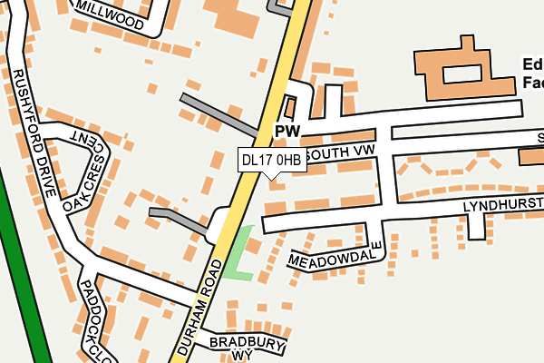
DL17 0HB is located in the Chilton electoral ward, within the unitary authority of County Durham and the English Parliamentary constituency of Sedgefield. The Sub Integrated Care Board (ICB) Location is NHS North East and North Cumbria ICB - 84H and the police force is Durham. This postcode has been in use since January 1980.


GetTheData
Source: OS OpenMap – Local (Ordnance Survey)
Source: OS VectorMap District (Ordnance Survey)
Licence: Open Government Licence (requires attribution)
| Easting | 428507 |
| Northing | 529299 |
| Latitude | 54.657992 |
| Longitude | -1.559650 |
GetTheData
Source: Open Postcode Geo
Licence: Open Government Licence
| Country | England |
| Postcode District | DL17 |
| ➜ DL17 open data dashboard ➜ See where DL17 is on a map ➜ Where is Chilton? | |
GetTheData
Source: Land Registry Price Paid Data
Licence: Open Government Licence
Elevation or altitude of DL17 0HB as distance above sea level:
| Metres | Feet | |
|---|---|---|
| Elevation | 100m | 328ft |
Elevation is measured from the approximate centre of the postcode, to the nearest point on an OS contour line from OS Terrain 50, which has contour spacing of ten vertical metres.
➜ How high above sea level am I? Find the elevation of your current position using your device's GPS.
GetTheData
Source: Open Postcode Elevation
Licence: Open Government Licence
| Ward | Chilton |
| Constituency | Sedgefield |
GetTheData
Source: ONS Postcode Database
Licence: Open Government Licence
| June 2022 | Violence and sexual offences | On or near Meadowdale | 118m |
| June 2022 | Violence and sexual offences | On or near Meadowdale | 118m |
| June 2022 | Violence and sexual offences | On or near Meadowdale | 118m |
| ➜ Get more crime data in our Crime section | |||
GetTheData
Source: data.police.uk
Licence: Open Government Licence
| New South View | Windlestone | 73m |
| New South View | Windlestone | 74m |
| Rushyford Drive (Street Not Known) | Chilton | 94m |
| Working Mens Club (A167 Durham Road) | Chilton | 133m |
| Working Mens Club (A167 Durham Road) | Chilton | 181m |
| Newton Aycliffe Station | 5.3km |
| Shildon Station | 6.1km |
GetTheData
Source: NaPTAN
Licence: Open Government Licence
| Percentage of properties with Next Generation Access | 100.0% |
| Percentage of properties with Superfast Broadband | 100.0% |
| Percentage of properties with Ultrafast Broadband | 0.0% |
| Percentage of properties with Full Fibre Broadband | 0.0% |
Superfast Broadband is between 30Mbps and 300Mbps
Ultrafast Broadband is > 300Mbps
| Percentage of properties unable to receive 2Mbps | 0.0% |
| Percentage of properties unable to receive 5Mbps | 0.0% |
| Percentage of properties unable to receive 10Mbps | 0.0% |
| Percentage of properties unable to receive 30Mbps | 0.0% |
GetTheData
Source: Ofcom
Licence: Ofcom Terms of Use (requires attribution)
GetTheData
Source: ONS Postcode Database
Licence: Open Government Licence


➜ Get more ratings from the Food Standards Agency
GetTheData
Source: Food Standards Agency
Licence: FSA terms & conditions
| Last Collection | |||
|---|---|---|---|
| Location | Mon-Fri | Sat | Distance |
| Broomside | 16:45 | 10:45 | 2,998m |
| Dean Bank West | 17:30 | 11:00 | 3,026m |
| Linden Road | 16:45 | 10:45 | 3,064m |
GetTheData
Source: Dracos
Licence: Creative Commons Attribution-ShareAlike
| Facility | Distance |
|---|---|
| Chilton Academy Chilton, Ferryhill Sports Hall, Grass Pitches, Squash Courts | 235m |
| Advantage Health Club (Rushyford) Rushyford, Ferryhill Swimming Pool, Health and Fitness Gym | 562m |
| Windlestone School Road Leading To Windlestone School, Chilton Sports Hall, Health and Fitness Gym, Artificial Grass Pitch, Grass Pitches | 848m |
GetTheData
Source: Active Places
Licence: Open Government Licence
| School | Phase of Education | Distance |
|---|---|---|
| Chilton Academy Chilton, Off New South View, Ferryhill, DL17 0PT | Primary | 271m |
| Aycliffe Secure Centre Care of: Durham County Council, 26 Chilton Way, Chilton, Ferryhill, DL17 0SD | Not applicable | 1.2km |
| Ferryhill Station Primary School Ferryhill Station, Ferryhill, DL17 0DB | Primary | 2.6km |
GetTheData
Source: Edubase
Licence: Open Government Licence
The below table lists the International Territorial Level (ITL) codes (formerly Nomenclature of Territorial Units for Statistics (NUTS) codes) and Local Administrative Units (LAU) codes for DL17 0HB:
| ITL 1 Code | Name |
|---|---|
| TLC | North East (England) |
| ITL 2 Code | Name |
| TLC1 | Tees Valley and Durham |
| ITL 3 Code | Name |
| TLC14 | Durham |
| LAU 1 Code | Name |
| E06000047 | County Durham |
GetTheData
Source: ONS Postcode Directory
Licence: Open Government Licence
The below table lists the Census Output Area (OA), Lower Layer Super Output Area (LSOA), and Middle Layer Super Output Area (MSOA) for DL17 0HB:
| Code | Name | |
|---|---|---|
| OA | E00105582 | |
| LSOA | E01020803 | County Durham 053B |
| MSOA | E02004338 | County Durham 053 |
GetTheData
Source: ONS Postcode Directory
Licence: Open Government Licence
| DL17 0PR | Shelley Terrace | 73m |
| DL17 0PJ | Woodham View | 79m |
| DL17 0EZ | Hillside Bungalows | 80m |
| DL17 0RW | Meadow Dale | 103m |
| DL17 0PS | New South View | 104m |
| DL17 0FB | Hillside Court | 138m |
| DL17 0PH | John Herriotts Court | 157m |
| DL17 0EY | 163m | |
| DL17 0HA | 189m | |
| DL17 0EL | Oak Crescent | 201m |
GetTheData
Source: Open Postcode Geo; Land Registry Price Paid Data
Licence: Open Government Licence