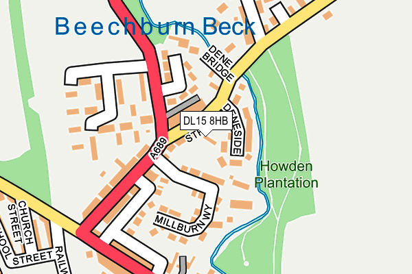
DL15 8HB lies on Eales Nook in Howden Le Wear, Crook. DL15 8HB is located in the Crook electoral ward, within the unitary authority of County Durham and the English Parliamentary constituency of North West Durham. The Sub Integrated Care Board (ICB) Location is NHS North East and North Cumbria ICB - 84H and the police force is Durham. This postcode has been in use since January 1980.


GetTheData
Source: OS OpenMap – Local (Ordnance Survey)
Source: OS VectorMap District (Ordnance Survey)
Licence: Open Government Licence (requires attribution)
| Easting | 416425 |
| Northing | 533510 |
| Latitude | 54.696368 |
| Longitude | -1.746692 |
GetTheData
Source: Open Postcode Geo
Licence: Open Government Licence
| Street | Eales Nook |
| Locality | Howden Le Wear |
| Town/City | Crook |
| Country | England |
| Postcode District | DL15 |
| ➜ DL15 open data dashboard ➜ See where DL15 is on a map ➜ Where is Howden-le-Wear? | |
GetTheData
Source: Land Registry Price Paid Data
Licence: Open Government Licence
Elevation or altitude of DL15 8HB as distance above sea level:
| Metres | Feet | |
|---|---|---|
| Elevation | 120m | 394ft |
Elevation is measured from the approximate centre of the postcode, to the nearest point on an OS contour line from OS Terrain 50, which has contour spacing of ten vertical metres.
➜ How high above sea level am I? Find the elevation of your current position using your device's GPS.
GetTheData
Source: Open Postcode Elevation
Licence: Open Government Licence
| Ward | Crook |
| Constituency | North West Durham |
GetTheData
Source: ONS Postcode Database
Licence: Open Government Licence
| June 2022 | Violence and sexual offences | On or near Millburn Way | 69m |
| June 2022 | Criminal damage and arson | On or near Dene Bridge | 105m |
| June 2022 | Violence and sexual offences | On or near High Street | 142m |
| ➜ Get more crime data in our Crime section | |||
GetTheData
Source: data.police.uk
Licence: Open Government Licence
| High Street (A689) | Howden Le Wear | 116m |
| Cemetery (A689) | Howden Le Wear | 142m |
| Cemetery (A689) | Howden Le Wear | 147m |
| Club (Rumby Hill Bank) | Howden Le Wear | 163m |
| Club (Rumby Hill Bank) | Howden Le Wear | 172m |
| Bishop Auckland Station | 6.2km |
GetTheData
Source: NaPTAN
Licence: Open Government Licence
| Percentage of properties with Next Generation Access | 100.0% |
| Percentage of properties with Superfast Broadband | 100.0% |
| Percentage of properties with Ultrafast Broadband | 0.0% |
| Percentage of properties with Full Fibre Broadband | 0.0% |
Superfast Broadband is between 30Mbps and 300Mbps
Ultrafast Broadband is > 300Mbps
| Percentage of properties unable to receive 2Mbps | 0.0% |
| Percentage of properties unable to receive 5Mbps | 0.0% |
| Percentage of properties unable to receive 10Mbps | 0.0% |
| Percentage of properties unable to receive 30Mbps | 0.0% |
GetTheData
Source: Ofcom
Licence: Ofcom Terms of Use (requires attribution)
GetTheData
Source: ONS Postcode Database
Licence: Open Government Licence


➜ Get more ratings from the Food Standards Agency
GetTheData
Source: Food Standards Agency
Licence: FSA terms & conditions
| Last Collection | |||
|---|---|---|---|
| Location | Mon-Fri | Sat | Distance |
| Old Hunwick | 17:00 | 10:30 | 2,597m |
| Hunwick Post Office | 17:00 | 10:45 | 2,757m |
| Temperance Terrace, Crook | 16:15 | 10:00 | 3,278m |
GetTheData
Source: Dracos
Licence: Creative Commons Attribution-ShareAlike
| Facility | Distance |
|---|---|
| Howden-le-wear Primary School School Street, Howden Le Wear, Crook Grass Pitches | 366m |
| Greenhead Playing Field New Road, Crook Grass Pitches | 681m |
| Glenholme Leisure Complex (Closed) New Road, Crook Swimming Pool, Health and Fitness Gym, Squash Courts | 1.5km |
GetTheData
Source: Active Places
Licence: Open Government Licence
| School | Phase of Education | Distance |
|---|---|---|
| Howden-le-Wear Primary School School Street, Howden-le-Wear, Crook, DL15 8HJ | Primary | 366m |
| Crook Primary School Croft Avenue, Crook, DL15 8QG | Primary | 1.8km |
| St Cuthbert's Catholic Primary School, Crook Church Hill, Crook, DL15 9DN | Primary | 2.3km |
GetTheData
Source: Edubase
Licence: Open Government Licence
The below table lists the International Territorial Level (ITL) codes (formerly Nomenclature of Territorial Units for Statistics (NUTS) codes) and Local Administrative Units (LAU) codes for DL15 8HB:
| ITL 1 Code | Name |
|---|---|
| TLC | North East (England) |
| ITL 2 Code | Name |
| TLC1 | Tees Valley and Durham |
| ITL 3 Code | Name |
| TLC14 | Durham |
| LAU 1 Code | Name |
| E06000047 | County Durham |
GetTheData
Source: ONS Postcode Directory
Licence: Open Government Licence
The below table lists the Census Output Area (OA), Lower Layer Super Output Area (LSOA), and Middle Layer Super Output Area (MSOA) for DL15 8HB:
| Code | Name | |
|---|---|---|
| OA | E00106018 | |
| LSOA | E01020887 | County Durham 045C |
| MSOA | E02004349 | County Durham 045 |
GetTheData
Source: ONS Postcode Directory
Licence: Open Government Licence
| DL15 8HD | Holly Terrace | 41m |
| DL15 8JR | Deneside | 62m |
| DL15 8EZ | High Street | 97m |
| DL15 8HE | Parkside | 102m |
| DL15 8FB | Milburn Way | 107m |
| DL15 8JP | Denebridge | 128m |
| DL15 8HA | High Street | 142m |
| DL15 8HF | Plantation View | 166m |
| DL15 8AD | Plantation Terrace | 182m |
| DL15 8GH | Sunnydene Meadows | 201m |
GetTheData
Source: Open Postcode Geo; Land Registry Price Paid Data
Licence: Open Government Licence