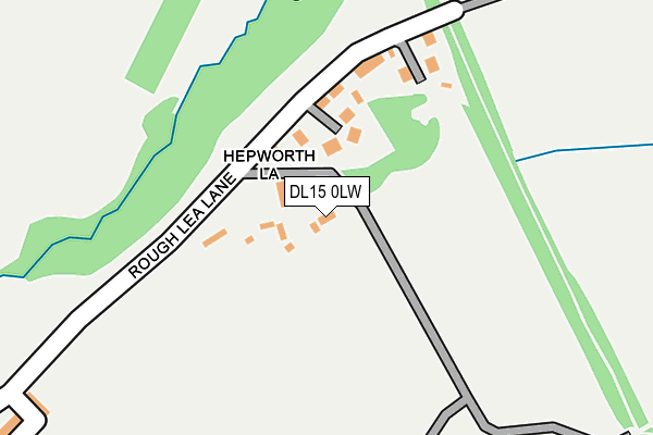
DL15 0LW is located in the Willington and Hunwick electoral ward, within the unitary authority of County Durham and the English Parliamentary constituency of North West Durham. The Sub Integrated Care Board (ICB) Location is NHS North East and North Cumbria ICB - 84H and the police force is Durham. This postcode has been in use since June 1996.


GetTheData
Source: OS OpenMap – Local (Ordnance Survey)
Source: OS VectorMap District (Ordnance Survey)
Licence: Open Government Licence (requires attribution)
| Easting | 419244 |
| Northing | 533504 |
| Latitude | 54.696215 |
| Longitude | -1.702955 |
GetTheData
Source: Open Postcode Geo
Licence: Open Government Licence
| Country | England |
| Postcode District | DL15 |
| ➜ DL15 open data dashboard ➜ See where DL15 is on a map ➜ Where is Hunwick? | |
GetTheData
Source: Land Registry Price Paid Data
Licence: Open Government Licence
Elevation or altitude of DL15 0LW as distance above sea level:
| Metres | Feet | |
|---|---|---|
| Elevation | 90m | 295ft |
Elevation is measured from the approximate centre of the postcode, to the nearest point on an OS contour line from OS Terrain 50, which has contour spacing of ten vertical metres.
➜ How high above sea level am I? Find the elevation of your current position using your device's GPS.
GetTheData
Source: Open Postcode Elevation
Licence: Open Government Licence
| Ward | Willington And Hunwick |
| Constituency | North West Durham |
GetTheData
Source: ONS Postcode Database
Licence: Open Government Licence
| June 2022 | Anti-social behaviour | On or near Hepworth Lane | 37m |
| June 2022 | Criminal damage and arson | On or near Hepworth Lane | 37m |
| June 2022 | Anti-social behaviour | On or near Hepworth Lane | 37m |
| ➜ Get more crime data in our Crime section | |||
GetTheData
Source: data.police.uk
Licence: Open Government Licence
| Lane Ends (B6286 Front Street) | Hunwick | 469m |
| Lane Ends (B6286 Front Street) | Hunwick | 478m |
| Helmington Hall (B6286 Hunwick Lane) | Hunwick | 503m |
| Helmington Hall (B6286 Hunwick Lane) | Hunwick | 511m |
| Club - Post Office (B6286 Wear View) | Hunwick | 544m |
| Bishop Auckland Station | 4.6km |
GetTheData
Source: NaPTAN
Licence: Open Government Licence
| Percentage of properties with Next Generation Access | 100.0% |
| Percentage of properties with Superfast Broadband | 100.0% |
| Percentage of properties with Ultrafast Broadband | 0.0% |
| Percentage of properties with Full Fibre Broadband | 0.0% |
Superfast Broadband is between 30Mbps and 300Mbps
Ultrafast Broadband is > 300Mbps
| Percentage of properties unable to receive 2Mbps | 0.0% |
| Percentage of properties unable to receive 5Mbps | 0.0% |
| Percentage of properties unable to receive 10Mbps | 0.0% |
| Percentage of properties unable to receive 30Mbps | 0.0% |
GetTheData
Source: Ofcom
Licence: Ofcom Terms of Use (requires attribution)
GetTheData
Source: ONS Postcode Database
Licence: Open Government Licence


➜ Get more ratings from the Food Standards Agency
GetTheData
Source: Food Standards Agency
Licence: FSA terms & conditions
| Last Collection | |||
|---|---|---|---|
| Location | Mon-Fri | Sat | Distance |
| Hunwick Post Office | 17:00 | 10:45 | 983m |
| Old Hunwick | 17:00 | 10:30 | 1,313m |
| High Bondgate | 17:30 | 11:00 | 3,832m |
GetTheData
Source: Dracos
Licence: Creative Commons Attribution-ShareAlike
| Facility | Distance |
|---|---|
| Hunwick Recreation Ground Hepworth Lane, Hunwick Grass Pitches | 319m |
| Hunwick Primary School Church Lane, Hunwick, Crook Grass Pitches | 902m |
| Parkside Academy Hall Lane Estate, Willington, Crook Sports Hall, Health and Fitness Gym, Artificial Grass Pitch, Grass Pitches, Studio | 1.4km |
GetTheData
Source: Active Places
Licence: Open Government Licence
| School | Phase of Education | Distance |
|---|---|---|
| Hunwick Primary School Church Lane, Hunwick, Crook, DL15 0JX | Primary | 896m |
| Sunnybrow Primary School Hunwick Lane, Crook, DL15 0LT | Primary | 1.1km |
| Parkside Academy Hall Lane Estate, Willington, Crook, DL15 0QF | Secondary | 1.4km |
GetTheData
Source: Edubase
Licence: Open Government Licence
The below table lists the International Territorial Level (ITL) codes (formerly Nomenclature of Territorial Units for Statistics (NUTS) codes) and Local Administrative Units (LAU) codes for DL15 0LW:
| ITL 1 Code | Name |
|---|---|
| TLC | North East (England) |
| ITL 2 Code | Name |
| TLC1 | Tees Valley and Durham |
| ITL 3 Code | Name |
| TLC14 | Durham |
| LAU 1 Code | Name |
| E06000047 | County Durham |
GetTheData
Source: ONS Postcode Directory
Licence: Open Government Licence
The below table lists the Census Output Area (OA), Lower Layer Super Output Area (LSOA), and Middle Layer Super Output Area (MSOA) for DL15 0LW:
| Code | Name | |
|---|---|---|
| OA | E00106022 | |
| LSOA | E01020888 | County Durham 057B |
| MSOA | E02004354 | County Durham 057 |
GetTheData
Source: ONS Postcode Directory
Licence: Open Government Licence
| DL15 0RQ | 60m | |
| DL15 0RH | Rough Lea Colliery | 126m |
| DL15 0LS | Rough Lea Terrace | 389m |
| DL15 0LP | Cooperative Terrace | 469m |
| DL15 0LE | Wear View | 510m |
| DL15 0LF | West View | 535m |
| DL15 0LG | Helmington Square | 537m |
| DL15 0LN | Coronation Terrace | 544m |
| DL15 0RG | 546m | |
| DL15 0LJ | Chapel Street | 580m |
GetTheData
Source: Open Postcode Geo; Land Registry Price Paid Data
Licence: Open Government Licence