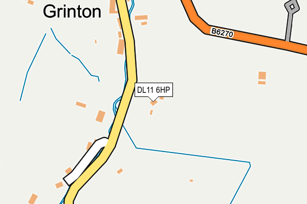
DL11 6HP is located in the Upper Dales electoral ward, within the unitary authority of North Yorkshire and the English Parliamentary constituency of Richmond (Yorks). The Sub Integrated Care Board (ICB) Location is NHS Humber and North Yorkshire ICB - 42D and the police force is North Yorkshire. This postcode has been in use since January 1980.


GetTheData
Source: OS OpenMap – Local (Ordnance Survey)
Source: OS VectorMap District (Ordnance Survey)
Licence: Open Government Licence (requires attribution)
| Easting | 404730 |
| Northing | 498165 |
| Latitude | 54.378963 |
| Longitude | -1.928686 |
GetTheData
Source: Open Postcode Geo
Licence: Open Government Licence
| Country | England |
| Postcode District | DL11 |
| ➜ DL11 open data dashboard ➜ See where DL11 is on a map ➜ Where is Grinton? | |
GetTheData
Source: Land Registry Price Paid Data
Licence: Open Government Licence
Elevation or altitude of DL11 6HP as distance above sea level:
| Metres | Feet | |
|---|---|---|
| Elevation | 200m | 656ft |
Elevation is measured from the approximate centre of the postcode, to the nearest point on an OS contour line from OS Terrain 50, which has contour spacing of ten vertical metres.
➜ How high above sea level am I? Find the elevation of your current position using your device's GPS.
GetTheData
Source: Open Postcode Elevation
Licence: Open Government Licence
| Ward | Upper Dales |
| Constituency | Richmond (Yorks) |
GetTheData
Source: ONS Postcode Database
Licence: Open Government Licence
| October 2021 | Criminal damage and arson | On or near B6270 | 288m |
| April 2021 | Anti-social behaviour | On or near B6270 | 288m |
| March 2021 | Anti-social behaviour | On or near B6270 | 288m |
| ➜ Get more crime data in our Crime section | |||
GetTheData
Source: data.police.uk
Licence: Open Government Licence
| Little Bridge (B6270) | Grinton | 266m |
| Little Bridge (B6270) | Grinton | 279m |
| Memorial (Anvil Square) | Reeth | 1,420m |
| Memorial (Anvil Square) | Reeth | 1,422m |
| Reeth Green (B6270) | Reeth | 1,491m |
GetTheData
Source: NaPTAN
Licence: Open Government Licence
| Percentage of properties with Next Generation Access | 100.0% |
| Percentage of properties with Superfast Broadband | 0.0% |
| Percentage of properties with Ultrafast Broadband | 0.0% |
| Percentage of properties with Full Fibre Broadband | 0.0% |
Superfast Broadband is between 30Mbps and 300Mbps
Ultrafast Broadband is > 300Mbps
| Percentage of properties unable to receive 2Mbps | 0.0% |
| Percentage of properties unable to receive 5Mbps | 0.0% |
| Percentage of properties unable to receive 10Mbps | 0.0% |
| Percentage of properties unable to receive 30Mbps | 100.0% |
GetTheData
Source: Ofcom
Licence: Ofcom Terms of Use (requires attribution)
GetTheData
Source: ONS Postcode Database
Licence: Open Government Licence


➜ Get more ratings from the Food Standards Agency
GetTheData
Source: Food Standards Agency
Licence: FSA terms & conditions
| Facility | Distance |
|---|---|
| Reeth & District Community Sports Club Ltd Caravan Site Road, Reeth Grass Pitches, Outdoor Tennis Courts | 975m |
GetTheData
Source: Active Places
Licence: Open Government Licence
| School | Phase of Education | Distance |
|---|---|---|
| Reeth Community Primary School Healaugh Road, Reeth, Richmond, DL11 6SP | Primary | 1.7km |
GetTheData
Source: Edubase
Licence: Open Government Licence
The below table lists the International Territorial Level (ITL) codes (formerly Nomenclature of Territorial Units for Statistics (NUTS) codes) and Local Administrative Units (LAU) codes for DL11 6HP:
| ITL 1 Code | Name |
|---|---|
| TLE | Yorkshire and The Humber |
| ITL 2 Code | Name |
| TLE2 | North Yorkshire |
| ITL 3 Code | Name |
| TLE22 | North Yorkshire CC |
| LAU 1 Code | Name |
| E07000166 | Richmondshire |
GetTheData
Source: ONS Postcode Directory
Licence: Open Government Licence
The below table lists the Census Output Area (OA), Lower Layer Super Output Area (LSOA), and Middle Layer Super Output Area (MSOA) for DL11 6HP:
| Code | Name | |
|---|---|---|
| OA | E00141435 | |
| LSOA | E01027773 | Richmondshire 005E |
| MSOA | E02005786 | Richmondshire 005 |
GetTheData
Source: ONS Postcode Directory
Licence: Open Government Licence
| DL11 6HR | 109m | |
| DL11 6HW | 177m | |
| DL11 6HN | 209m | |
| DL11 6HJ | 251m | |
| DL11 6HL | Swale Hall Lane | 262m |
| DL11 6HH | 293m | |
| DL11 6AW | 801m | |
| DL11 6AR | 867m | |
| DL11 6AS | 929m | |
| DL11 6TR | 1198m |
GetTheData
Source: Open Postcode Geo; Land Registry Price Paid Data
Licence: Open Government Licence