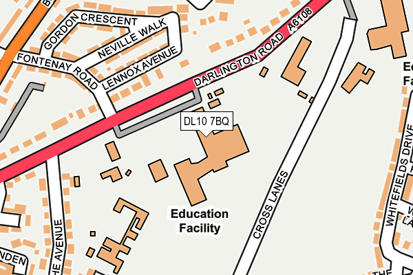
DL10 7BQ is located in the Richmond electoral ward, within the unitary authority of North Yorkshire and the English Parliamentary constituency of Richmond (Yorks). The Sub Integrated Care Board (ICB) Location is NHS Humber and North Yorkshire ICB - 42D and the police force is North Yorkshire. This postcode has been in use since January 1980.


GetTheData
Source: OS OpenMap – Local (Ordnance Survey)
Source: OS VectorMap District (Ordnance Survey)
Licence: Open Government Licence (requires attribution)
| Easting | 418068 |
| Northing | 501397 |
| Latitude | 54.407724 |
| Longitude | -1.723155 |
GetTheData
Source: Open Postcode Geo
Licence: Open Government Licence
| Country | England |
| Postcode District | DL10 |
| ➜ DL10 open data dashboard ➜ See where DL10 is on a map ➜ Where is Richmond? | |
GetTheData
Source: Land Registry Price Paid Data
Licence: Open Government Licence
Elevation or altitude of DL10 7BQ as distance above sea level:
| Metres | Feet | |
|---|---|---|
| Elevation | 150m | 492ft |
Elevation is measured from the approximate centre of the postcode, to the nearest point on an OS contour line from OS Terrain 50, which has contour spacing of ten vertical metres.
➜ How high above sea level am I? Find the elevation of your current position using your device's GPS.
GetTheData
Source: Open Postcode Elevation
Licence: Open Government Licence
| Ward | Richmond |
| Constituency | Richmond (Yorks) |
GetTheData
Source: ONS Postcode Database
Licence: Open Government Licence
| June 2022 | Violence and sexual offences | On or near Lennox Avenue | 140m |
| June 2022 | Anti-social behaviour | On or near Pilmoor Close | 316m |
| June 2022 | Violence and sexual offences | On or near Vinstra Close | 384m |
| ➜ Get more crime data in our Crime section | |||
GetTheData
Source: data.police.uk
Licence: Open Government Licence
| Fontenay Road (A6108) | Easby | 98m |
| Fontenay Road (A6108) | Easby | 110m |
| Cross Lanes (Darlington Road) | Easby | 247m |
| Darlington Road | Richmond | 284m |
| Darlington Road | Richmond | 288m |
GetTheData
Source: NaPTAN
Licence: Open Government Licence
GetTheData
Source: ONS Postcode Database
Licence: Open Government Licence


➜ Get more ratings from the Food Standards Agency
GetTheData
Source: Food Standards Agency
Licence: FSA terms & conditions
| Last Collection | |||
|---|---|---|---|
| Location | Mon-Fri | Sat | Distance |
| Darlington Road | 17:30 | 11:30 | 172m |
| Gilling Road | 17:30 | 11:30 | 312m |
| Cross Lanes | 17:15 | 11:30 | 338m |
GetTheData
Source: Dracos
Licence: Creative Commons Attribution-ShareAlike
| Facility | Distance |
|---|---|
| Richmond School Darlington Road, Richmond Sports Hall, Artificial Grass Pitch, Health and Fitness Gym, Grass Pitches, Studio, Outdoor Tennis Courts | 0m |
| Richmond Methodist Primary School Darlington Road, Richmond Grass Pitches | 166m |
| Saint Francis Xavier School Darlington Road, Richmond Health and Fitness Gym, Grass Pitches, Sports Hall, Studio | 313m |
GetTheData
Source: Active Places
Licence: Open Government Licence
| School | Phase of Education | Distance |
|---|---|---|
| Richmond School Darlington Road, Richmond, DL10 7BQ | Secondary | 148m |
| Richmond Methodist Primary School Darlington Road, Richmond, DL10 7BH | Primary | 169m |
| St Mary's Catholic Primary School - a Catholic voluntary academy Cross Lanes, Richmond, DL10 7DZ | Primary | 239m |
GetTheData
Source: Edubase
Licence: Open Government Licence
The below table lists the International Territorial Level (ITL) codes (formerly Nomenclature of Territorial Units for Statistics (NUTS) codes) and Local Administrative Units (LAU) codes for DL10 7BQ:
| ITL 1 Code | Name |
|---|---|
| TLE | Yorkshire and The Humber |
| ITL 2 Code | Name |
| TLE2 | North Yorkshire |
| ITL 3 Code | Name |
| TLE22 | North Yorkshire CC |
| LAU 1 Code | Name |
| E07000166 | Richmondshire |
GetTheData
Source: ONS Postcode Directory
Licence: Open Government Licence
The below table lists the Census Output Area (OA), Lower Layer Super Output Area (LSOA), and Middle Layer Super Output Area (MSOA) for DL10 7BQ:
| Code | Name | |
|---|---|---|
| OA | E00141415 | |
| LSOA | E01027767 | Richmondshire 002C |
| MSOA | E02005783 | Richmondshire 002 |
GetTheData
Source: ONS Postcode Directory
Licence: Open Government Licence
| DL10 5AF | Lennox Avenue | 150m |
| DL10 7BG | Darlington Road | 154m |
| DL10 5FB | Jubilee Court | 172m |
| DL10 5AG | Neville Walk | 173m |
| DL10 5AQ | Gordon Crescent | 219m |
| DL10 5AE | Fontenay Road | 222m |
| DL10 5AL | Earl Edwin Drive | 259m |
| DL10 7BE | Darlington Road | 264m |
| DL10 7BA | The Crescent | 268m |
| DL10 7AZ | The Avenue | 284m |
GetTheData
Source: Open Postcode Geo; Land Registry Price Paid Data
Licence: Open Government Licence