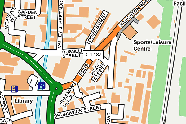
DL1 1SZ lies on Freemans Place in Darlington. DL1 1SZ is located in the Park East electoral ward, within the unitary authority of Darlington and the English Parliamentary constituency of Darlington. The Sub Integrated Care Board (ICB) Location is NHS North East and North Cumbria ICB - 16C and the police force is Durham. This postcode has been in use since January 1980.


GetTheData
Source: OS OpenMap – Local (Ordnance Survey)
Source: OS VectorMap District (Ordnance Survey)
Licence: Open Government Licence (requires attribution)
| Easting | 429327 |
| Northing | 514779 |
| Latitude | 54.527451 |
| Longitude | -1.548374 |
GetTheData
Source: Open Postcode Geo
Licence: Open Government Licence
| Street | Freemans Place |
| Town/City | Darlington |
| Country | England |
| Postcode District | DL1 |
| ➜ DL1 open data dashboard ➜ See where DL1 is on a map ➜ Where is Darlington? | |
GetTheData
Source: Land Registry Price Paid Data
Licence: Open Government Licence
Elevation or altitude of DL1 1SZ as distance above sea level:
| Metres | Feet | |
|---|---|---|
| Elevation | 40m | 131ft |
Elevation is measured from the approximate centre of the postcode, to the nearest point on an OS contour line from OS Terrain 50, which has contour spacing of ten vertical metres.
➜ How high above sea level am I? Find the elevation of your current position using your device's GPS.
GetTheData
Source: Open Postcode Elevation
Licence: Open Government Licence
| Ward | Park East |
| Constituency | Darlington |
GetTheData
Source: ONS Postcode Database
Licence: Open Government Licence
| January 2024 | Burglary | On or near Montrose Street North Back | 401m |
| January 2024 | Burglary | On or near Montrose Street North Back | 401m |
| January 2024 | Burglary | On or near Montrose Street North Back | 401m |
| ➜ Get more crime data in our Crime section | |||
GetTheData
Source: data.police.uk
Licence: Open Government Licence
| Coburg Street (Freeman's Place) | Haughton Road | 61m |
| Bannatyne's Health Club (Haughton Road) | Haughton Road | 139m |
| Bannatyne's Health Club (Haughton Road) | Haughton Road | 160m |
| Eastmount Road (Haughton Road) | Haughton Road | 324m |
| Civic Theatre (Parkgate) | Darlington | 325m |
| Darlington Station | 0.8km |
| North Road Station | 1km |
GetTheData
Source: NaPTAN
Licence: Open Government Licence
| Percentage of properties with Next Generation Access | 100.0% |
| Percentage of properties with Superfast Broadband | 100.0% |
| Percentage of properties with Ultrafast Broadband | 85.7% |
| Percentage of properties with Full Fibre Broadband | 0.0% |
Superfast Broadband is between 30Mbps and 300Mbps
Ultrafast Broadband is > 300Mbps
| Percentage of properties unable to receive 2Mbps | 0.0% |
| Percentage of properties unable to receive 5Mbps | 0.0% |
| Percentage of properties unable to receive 10Mbps | 0.0% |
| Percentage of properties unable to receive 30Mbps | 0.0% |
GetTheData
Source: Ofcom
Licence: Ofcom Terms of Use (requires attribution)
GetTheData
Source: ONS Postcode Database
Licence: Open Government Licence


➜ Get more ratings from the Food Standards Agency
GetTheData
Source: Food Standards Agency
Licence: FSA terms & conditions
| Last Collection | |||
|---|---|---|---|
| Location | Mon-Fri | Sat | Distance |
| Crown Street | 17:15 | 327m | |
| Crown Street Branch Office | 19:00 | 12:30 | 327m |
| Eastmount | 17:30 | 10:45 | 353m |
GetTheData
Source: Dracos
Licence: Creative Commons Attribution-ShareAlike
| Facility | Distance |
|---|---|
| Bannatyne Health Club (Darlington) Haughton Road, Darlington Swimming Pool, Health and Fitness Gym, Studio | 152m |
| The Gym Group (Darlington) Eastmount Road, Darlington Health and Fitness Gym, Studio | 468m |
| Darlington College Haughton Road, Darlington Sports Hall, Health and Fitness Gym, Grass Pitches | 524m |
GetTheData
Source: Active Places
Licence: Open Government Licence
| School | Phase of Education | Distance |
|---|---|---|
| Borough Road Nursery School Borough Road, Darlington, DL1 1SG | Nursery | 208m |
| Darlington College Central Park, Haughton Road, Darlington, DL1 1DR | 16 plus | 528m |
| Corporation Road Community Primary School Corporation Road, Darlington, DL3 6AR | Primary | 725m |
GetTheData
Source: Edubase
Licence: Open Government Licence
The below table lists the International Territorial Level (ITL) codes (formerly Nomenclature of Territorial Units for Statistics (NUTS) codes) and Local Administrative Units (LAU) codes for DL1 1SZ:
| ITL 1 Code | Name |
|---|---|
| TLC | North East (England) |
| ITL 2 Code | Name |
| TLC1 | Tees Valley and Durham |
| ITL 3 Code | Name |
| TLC13 | Darlington |
| LAU 1 Code | Name |
| E06000005 | Darlington |
GetTheData
Source: ONS Postcode Directory
Licence: Open Government Licence
The below table lists the Census Output Area (OA), Lower Layer Super Output Area (LSOA), and Middle Layer Super Output Area (MSOA) for DL1 1SZ:
| Code | Name | |
|---|---|---|
| OA | E00062061 | |
| LSOA | E01033483 | Darlington 008E |
| MSOA | E02002566 | Darlington 008 |
GetTheData
Source: ONS Postcode Directory
Licence: Open Government Licence
| DL1 1SY | Hilda Street | 29m |
| DL1 1SS | Haughton Road | 64m |
| DL1 1SR | Borough Road | 68m |
| DL1 1SW | Borough Road | 74m |
| DL1 1TB | Russell Street | 76m |
| DL1 1SU | Haughton Road | 110m |
| DL1 1TD | Lodge Street | 117m |
| DL1 1GB | St Cuthberts Way | 154m |
| DL1 1QN | Weir Street | 222m |
| DL1 1PY | Valley Street North | 228m |
GetTheData
Source: Open Postcode Geo; Land Registry Price Paid Data
Licence: Open Government Licence