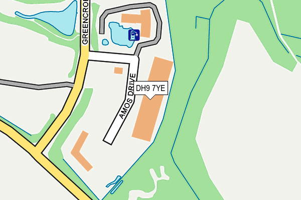
DH9 7YE lies on Amos Drive in Greencroft Industrial Park, Stanley. DH9 7YE is located in the Annfield Plain electoral ward, within the unitary authority of County Durham and the English Parliamentary constituency of North Durham. The Sub Integrated Care Board (ICB) Location is NHS North East and North Cumbria ICB - 84H and the police force is Durham. This postcode has been in use since October 2005.


GetTheData
Source: OS OpenMap – Local (Ordnance Survey)
Source: OS VectorMap District (Ordnance Survey)
Licence: Open Government Licence (requires attribution)
| Easting | 416615 |
| Northing | 550502 |
| Latitude | 54.849058 |
| Longitude | -1.742778 |
GetTheData
Source: Open Postcode Geo
Licence: Open Government Licence
| Street | Amos Drive |
| Locality | Greencroft Industrial Park |
| Town/City | Stanley |
| Country | England |
| Postcode District | DH9 |
| ➜ DH9 open data dashboard ➜ See where DH9 is on a map ➜ Where is Annfield Plain? | |
GetTheData
Source: Land Registry Price Paid Data
Licence: Open Government Licence
Elevation or altitude of DH9 7YE as distance above sea level:
| Metres | Feet | |
|---|---|---|
| Elevation | 240m | 787ft |
Elevation is measured from the approximate centre of the postcode, to the nearest point on an OS contour line from OS Terrain 50, which has contour spacing of ten vertical metres.
➜ How high above sea level am I? Find the elevation of your current position using your device's GPS.
GetTheData
Source: Open Postcode Elevation
Licence: Open Government Licence
| Ward | Annfield Plain |
| Constituency | North Durham |
GetTheData
Source: ONS Postcode Database
Licence: Open Government Licence
| June 2023 | Other theft | On or near Parkhead | 352m |
| January 2023 | Anti-social behaviour | On or near Parkhead | 352m |
| November 2022 | Anti-social behaviour | On or near Parkhead | 352m |
| ➜ Get more crime data in our Crime section | |||
GetTheData
Source: data.police.uk
Licence: Open Government Licence
| Industrial Estate Lake (Greencroft Parkway) | Greencroft | 106m |
| Industrial Estate Lake (Greencroft Parkway) | Greencroft | 135m |
| Industrial Estate North End (Greencroft Parkway) | Greencroft | 306m |
| Industrial Estate North End (Greencroft Parkway) | Greencroft | 384m |
| Morrison Busty (A6076 - Lanchester Road) | Annfield Plain | 699m |
GetTheData
Source: NaPTAN
Licence: Open Government Licence
GetTheData
Source: ONS Postcode Database
Licence: Open Government Licence


➜ Get more ratings from the Food Standards Agency
GetTheData
Source: Food Standards Agency
Licence: FSA terms & conditions
| Last Collection | |||
|---|---|---|---|
| Location | Mon-Fri | Sat | Distance |
| Iveston | 16:15 | 11:15 | 2,644m |
| Post Office, Coop Terrace | 16:30 | 11:45 | 3,236m |
| Deneside, Lanchester | 16:30 | 07:15 | 3,341m |
GetTheData
Source: Dracos
Licence: Creative Commons Attribution-ShareAlike
| Facility | Distance |
|---|---|
| Morrison Welfare Morrison Road, Stanley Grass Pitches | 660m |
| Annfield Plain Park Park Close, Stanley Grass Pitches, Outdoor Tennis Courts | 674m |
| Derwent Park West Road, Annfield Plain Grass Pitches | 782m |
GetTheData
Source: Active Places
Licence: Open Government Licence
| School | Phase of Education | Distance |
|---|---|---|
| Annfield Plain Infant School Northgate, Annfield Plain, Stanley, DH9 7UY | Primary | 857m |
| Annfield Plain Junior School Front Street, Annfield Plain, Stanley, DH9 7ST | Primary | 1.1km |
| Catchgate Primary School Blackett Street, Stanley, DH9 8LX | Primary | 1.4km |
GetTheData
Source: Edubase
Licence: Open Government Licence
The below table lists the International Territorial Level (ITL) codes (formerly Nomenclature of Territorial Units for Statistics (NUTS) codes) and Local Administrative Units (LAU) codes for DH9 7YE:
| ITL 1 Code | Name |
|---|---|
| TLC | North East (England) |
| ITL 2 Code | Name |
| TLC1 | Tees Valley and Durham |
| ITL 3 Code | Name |
| TLC14 | Durham |
| LAU 1 Code | Name |
| E06000047 | County Durham |
GetTheData
Source: ONS Postcode Directory
Licence: Open Government Licence
The below table lists the Census Output Area (OA), Lower Layer Super Output Area (LSOA), and Middle Layer Super Output Area (MSOA) for DH9 7YE:
| Code | Name | |
|---|---|---|
| OA | E00104648 | |
| LSOA | E01020625 | County Durham 009B |
| MSOA | E02004302 | County Durham 009 |
GetTheData
Source: ONS Postcode Directory
Licence: Open Government Licence
| DH9 7YB | Parkhead | 408m |
| DH9 7XF | 690m | |
| DH9 8UD | Scafell Court | 765m |
| DH9 8NX | The Avenue | 771m |
| DH9 8PA | The Villas | 772m |
| DH9 8PB | Moor View Terrace | 787m |
| DH9 7RX | Morrison Road | 805m |
| DH9 8PD | Greencroft Terrace | 810m |
| DH9 7UW | Park Close | 817m |
| DH9 8PE | Chirnside Terrace | 823m |
GetTheData
Source: Open Postcode Geo; Land Registry Price Paid Data
Licence: Open Government Licence