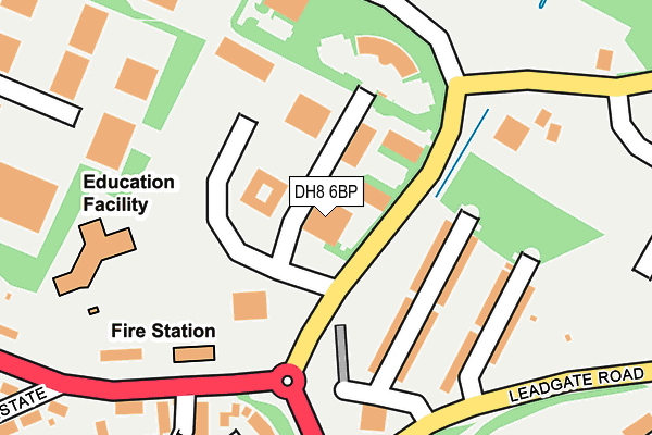
DH8 6BP is located in the Consett North electoral ward, within the unitary authority of County Durham and the English Parliamentary constituency of North West Durham. The Sub Integrated Care Board (ICB) Location is NHS North East and North Cumbria ICB - 84H and the police force is Durham. This postcode has been in use since August 1992.


GetTheData
Source: OS OpenMap – Local (Ordnance Survey)
Source: OS VectorMap District (Ordnance Survey)
Licence: Open Government Licence (requires attribution)
| Easting | 411768 |
| Northing | 551774 |
| Latitude | 54.860625 |
| Longitude | -1.818211 |
GetTheData
Source: Open Postcode Geo
Licence: Open Government Licence
| Country | England |
| Postcode District | DH8 |
| ➜ DH8 open data dashboard ➜ See where DH8 is on a map ➜ Where is Consett? | |
GetTheData
Source: Land Registry Price Paid Data
Licence: Open Government Licence
Elevation or altitude of DH8 6BP as distance above sea level:
| Metres | Feet | |
|---|---|---|
| Elevation | 260m | 853ft |
Elevation is measured from the approximate centre of the postcode, to the nearest point on an OS contour line from OS Terrain 50, which has contour spacing of ten vertical metres.
➜ How high above sea level am I? Find the elevation of your current position using your device's GPS.
GetTheData
Source: Open Postcode Elevation
Licence: Open Government Licence
| Ward | Consett North |
| Constituency | North West Durham |
GetTheData
Source: ONS Postcode Database
Licence: Open Government Licence
| June 2022 | Shoplifting | On or near Leadgate Road | 242m |
| June 2022 | Violence and sexual offences | On or near Leadgate Road | 242m |
| June 2022 | Other theft | On or near Leadgate Road | 289m |
| ➜ Get more crime data in our Crime section | |||
GetTheData
Source: data.police.uk
Licence: Open Government Licence
| Werdohl Way (Street Not Known) | Consett | 74m |
| Werdohl Way (Street Not Known) | Consett | 82m |
| Leadgate Rd Service Station (Leadgate Road) | Consett | 236m |
| Leadgate Rd Service Station (Leadgate Road) | Consett | 267m |
| Industrial Estate Werdohl Way (Wehdohl Way) | Number One | 328m |
GetTheData
Source: NaPTAN
Licence: Open Government Licence
| Median download speed | 40.0Mbps |
| Average download speed | 37.7Mbps |
| Maximum download speed | 68.15Mbps |
| Median upload speed | 10.0Mbps |
| Average upload speed | 7.9Mbps |
| Maximum upload speed | 13.14Mbps |
GetTheData
Source: Ofcom
Licence: Ofcom Terms of Use (requires attribution)
GetTheData
Source: ONS Postcode Database
Licence: Open Government Licence


➜ Get more ratings from the Food Standards Agency
GetTheData
Source: Food Standards Agency
Licence: FSA terms & conditions
| Last Collection | |||
|---|---|---|---|
| Location | Mon-Fri | Sat | Distance |
| Leadgate Industrial Estate | 18:30 | 12:00 | 175m |
| Villa Real Bungalows | 16:00 | 12:00 | 226m |
| Villa Real Road | 16:00 | 12:00 | 357m |
GetTheData
Source: Dracos
Licence: Creative Commons Attribution-ShareAlike
| Facility | Distance |
|---|---|
| Leadgate Cricket Club Garden Place, Leadgate, Consett Grass Pitches | 455m |
| Spartan Performance Number One Industrial Estate, Consett Health and Fitness Gym | 461m |
| Cutz & Curves Gymnasium West Parade, Leadgate, Consett Health and Fitness Gym, Studio | 540m |
GetTheData
Source: Active Places
Licence: Open Government Licence
| School | Phase of Education | Distance |
|---|---|---|
| Villa Real School Villa Real Road, Consett, DH8 6BH | Not applicable | 236m |
| Beechdale Nursery School Beechdale Road, Consett, DH8 6AY | Nursery | 556m |
| Consett Junior School Beechdale Road, Consett, DH8 6AY | Primary | 557m |
GetTheData
Source: Edubase
Licence: Open Government Licence
The below table lists the International Territorial Level (ITL) codes (formerly Nomenclature of Territorial Units for Statistics (NUTS) codes) and Local Administrative Units (LAU) codes for DH8 6BP:
| ITL 1 Code | Name |
|---|---|
| TLC | North East (England) |
| ITL 2 Code | Name |
| TLC1 | Tees Valley and Durham |
| ITL 3 Code | Name |
| TLC14 | Durham |
| LAU 1 Code | Name |
| E06000047 | County Durham |
GetTheData
Source: ONS Postcode Directory
Licence: Open Government Licence
The below table lists the Census Output Area (OA), Lower Layer Super Output Area (LSOA), and Middle Layer Super Output Area (MSOA) for DH8 6BP:
| Code | Name | |
|---|---|---|
| OA | E00104726 | |
| LSOA | E01020641 | County Durham 010C |
| MSOA | E02004303 | County Durham 010 |
GetTheData
Source: ONS Postcode Directory
Licence: Open Government Licence
| DH8 6BQ | Villa Real Bungalows | 155m |
| DH8 6FD | Carr House Mews | 311m |
| DH8 6BH | Villa Real Road | 380m |
| DH8 6FF | Granary Court | 391m |
| DH8 6BJ | Villa Real Estate | 428m |
| DH8 6FE | Newbell Court | 446m |
| DH8 6DQ | Villa Real Court | 476m |
| DH8 7PJ | West Parade | 487m |
| DH8 6EA | Garden Place | 494m |
| DH8 6BW | Walton Terrace | 512m |
GetTheData
Source: Open Postcode Geo; Land Registry Price Paid Data
Licence: Open Government Licence