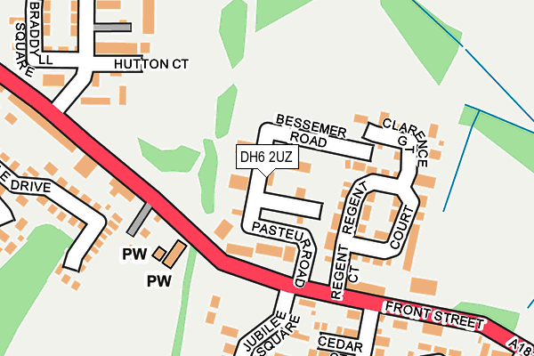
DH6 2UZ is located in the Shotton and South Hetton electoral ward, within the unitary authority of County Durham and the English Parliamentary constituency of Easington. The Sub Integrated Care Board (ICB) Location is NHS North East and North Cumbria ICB - 84H and the police force is Durham. This postcode has been in use since June 1981.


GetTheData
Source: OS OpenMap – Local (Ordnance Survey)
Source: OS VectorMap District (Ordnance Survey)
Licence: Open Government Licence (requires attribution)
| Easting | 437899 |
| Northing | 545327 |
| Latitude | 54.801394 |
| Longitude | -1.411983 |
GetTheData
Source: Open Postcode Geo
Licence: Open Government Licence
| Country | England |
| Postcode District | DH6 |
| ➜ DH6 open data dashboard ➜ See where DH6 is on a map ➜ Where is South Hetton? | |
GetTheData
Source: Land Registry Price Paid Data
Licence: Open Government Licence
Elevation or altitude of DH6 2UZ as distance above sea level:
| Metres | Feet | |
|---|---|---|
| Elevation | 130m | 427ft |
Elevation is measured from the approximate centre of the postcode, to the nearest point on an OS contour line from OS Terrain 50, which has contour spacing of ten vertical metres.
➜ How high above sea level am I? Find the elevation of your current position using your device's GPS.
GetTheData
Source: Open Postcode Elevation
Licence: Open Government Licence
| Ward | Shotton And South Hetton |
| Constituency | Easington |
GetTheData
Source: ONS Postcode Database
Licence: Open Government Licence
| January 2024 | Anti-social behaviour | On or near Charters Crescent | 355m |
| January 2024 | Criminal damage and arson | On or near Charters Crescent | 355m |
| January 2024 | Criminal damage and arson | On or near Charters Crescent | 355m |
| ➜ Get more crime data in our Crime section | |||
GetTheData
Source: data.police.uk
Licence: Open Government Licence
| Station Ph (A182 Front Street) | South Hetton | 122m |
| Station Ph (A182 Front Street) | South Hetton | 135m |
| Hedley Terrace (A182 Front Street) | South Hetton | 303m |
| Grey Horse (A182 Front Street) | South Hetton | 398m |
| Grey Horse (A182 Front Street) | South Hetton | 419m |
| Seaham Station | 5.9km |
GetTheData
Source: NaPTAN
Licence: Open Government Licence
GetTheData
Source: ONS Postcode Database
Licence: Open Government Licence


➜ Get more ratings from the Food Standards Agency
GetTheData
Source: Food Standards Agency
Licence: FSA terms & conditions
| Last Collection | |||
|---|---|---|---|
| Location | Mon-Fri | Sat | Distance |
| Old Post Office, | 16:00 | 11:30 | 420m |
| Dunelm Road, Hetton Le Hole | 17:30 | 11:45 | 965m |
| Easington Lane | 17:15 | 11:45 | 1,839m |
GetTheData
Source: Dracos
Licence: Creative Commons Attribution-ShareAlike
| Facility | Distance |
|---|---|
| South Hetton Primary School Frederick Terrace, South Hetton, Durham Grass Pitches | 281m |
| South Hetton Miners Welfare Recreation Ground Front Street, South Hetton Grass Pitches | 751m |
| Easington Lane Primary School High Street, Easington Lane, Houghton Le Spring Grass Pitches, Sports Hall | 1.6km |
GetTheData
Source: Active Places
Licence: Open Government Licence
| School | Phase of Education | Distance |
|---|---|---|
| South Hetton Primary Frederick Terrace, South Hetton, Durham, DH6 2TJ | Primary | 280m |
| Easington Lane Primary School High Street, Easington Lane, Houghton le Spring, DH5 0JT | Primary | 1.5km |
| St Joseph's Catholic Primary School, Murton Church Lane, Murton, Seaham, SR7 9RD | Primary | 2km |
GetTheData
Source: Edubase
Licence: Open Government Licence
The below table lists the International Territorial Level (ITL) codes (formerly Nomenclature of Territorial Units for Statistics (NUTS) codes) and Local Administrative Units (LAU) codes for DH6 2UZ:
| ITL 1 Code | Name |
|---|---|
| TLC | North East (England) |
| ITL 2 Code | Name |
| TLC1 | Tees Valley and Durham |
| ITL 3 Code | Name |
| TLC14 | Durham |
| LAU 1 Code | Name |
| E06000047 | County Durham |
GetTheData
Source: ONS Postcode Directory
Licence: Open Government Licence
The below table lists the Census Output Area (OA), Lower Layer Super Output Area (LSOA), and Middle Layer Super Output Area (MSOA) for DH6 2UZ:
| Code | Name | |
|---|---|---|
| OA | E00105325 | |
| LSOA | E01033206 | County Durham 021G |
| MSOA | E02004323 | County Durham 021 |
GetTheData
Source: ONS Postcode Directory
Licence: Open Government Licence
| DH6 2TT | Regent Court | 117m |
| DH6 2UA | Front Street | 152m |
| DH6 2TX | Clarence Gate | 162m |
| DH6 2TE | Cedar Court | 188m |
| DH6 2UB | Front Street | 196m |
| DH6 2TR | Jubilee Square | 198m |
| DH6 2US | Hutton Court | 209m |
| DH6 2UX | Ravensworth Court | 211m |
| DH6 2TG | Front Street | 222m |
| DH6 2XG | Pinedale Drive | 258m |
GetTheData
Source: Open Postcode Geo; Land Registry Price Paid Data
Licence: Open Government Licence