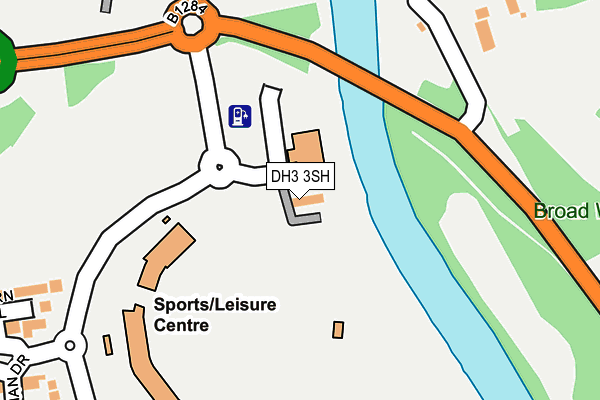
DH3 3SH is located in the Chester-le-Street East electoral ward, within the unitary authority of County Durham and the English Parliamentary constituency of North Durham. The Sub Integrated Care Board (ICB) Location is NHS North East and North Cumbria ICB - 84H and the police force is Durham. This postcode has been in use since December 1997.


GetTheData
Source: OS OpenMap – Local (Ordnance Survey)
Source: OS VectorMap District (Ordnance Survey)
Licence: Open Government Licence (requires attribution)
| Easting | 428349 |
| Northing | 550734 |
| Latitude | 54.850611 |
| Longitude | -1.560006 |
GetTheData
Source: Open Postcode Geo
Licence: Open Government Licence
| Country | England |
| Postcode District | DH3 |
➜ See where DH3 is on a map ➜ Where is Chester-le-Street? | |
GetTheData
Source: Land Registry Price Paid Data
Licence: Open Government Licence
Elevation or altitude of DH3 3SH as distance above sea level:
| Metres | Feet | |
|---|---|---|
| Elevation | 10m | 33ft |
Elevation is measured from the approximate centre of the postcode, to the nearest point on an OS contour line from OS Terrain 50, which has contour spacing of ten vertical metres.
➜ How high above sea level am I? Find the elevation of your current position using your device's GPS.
GetTheData
Source: Open Postcode Elevation
Licence: Open Government Licence
| Ward | Chester-le-street East |
| Constituency | North Durham |
GetTheData
Source: ONS Postcode Database
Licence: Open Government Licence
| Durham County Cricket Ground (Unclassified) | Chester-le-street | 134m |
| Golf Club - Bridge (B1284 Lumley New Road) | Chester-le-street | 188m |
| Golf Club - Bridge (B1284 Lumley New Road) | Chester-le-street | 214m |
| Riverside Cricket Ground (B1284 Lumley New Road) | Chester-le-street | 236m |
| Riverside Cricket Ground (B1284 Lumley New Road) | Chester-le-street | 266m |
| Chester-le-Street Station | 1.2km |
GetTheData
Source: NaPTAN
Licence: Open Government Licence
| Percentage of properties with Next Generation Access | 100.0% |
| Percentage of properties with Superfast Broadband | 100.0% |
| Percentage of properties with Ultrafast Broadband | 0.0% |
| Percentage of properties with Full Fibre Broadband | 0.0% |
Superfast Broadband is between 30Mbps and 300Mbps
Ultrafast Broadband is > 300Mbps
| Percentage of properties unable to receive 2Mbps | 0.0% |
| Percentage of properties unable to receive 5Mbps | 0.0% |
| Percentage of properties unable to receive 10Mbps | 0.0% |
| Percentage of properties unable to receive 30Mbps | 0.0% |
GetTheData
Source: Ofcom
Licence: Ofcom Terms of Use (requires attribution)
GetTheData
Source: ONS Postcode Database
Licence: Open Government Licence


➜ Get more ratings from the Food Standards Agency
GetTheData
Source: Food Standards Agency
Licence: FSA terms & conditions
| Last Collection | |||
|---|---|---|---|
| Location | Mon-Fri | Sat | Distance |
| Bradman Drive | 17:30 | 11:30 | 383m |
| Ropery Lane | 18:30 | 11:45 | 469m |
| Creighton Avenue | 17:30 | 11:30 | 620m |
GetTheData
Source: Dracos
Licence: Creative Commons Attribution-ShareAlike
| Risk of DH3 3SH flooding from rivers and sea | High |
| ➜ DH3 3SH flood map | |
GetTheData
Source: Open Flood Risk by Postcode
Licence: Open Government Licence
The below table lists the International Territorial Level (ITL) codes (formerly Nomenclature of Territorial Units for Statistics (NUTS) codes) and Local Administrative Units (LAU) codes for DH3 3SH:
| ITL 1 Code | Name |
|---|---|
| TLC | North East (England) |
| ITL 2 Code | Name |
| TLC1 | Tees Valley and Durham |
| ITL 3 Code | Name |
| TLC14 | Durham |
| LAU 1 Code | Name |
| E06000047 | County Durham |
GetTheData
Source: ONS Postcode Directory
Licence: Open Government Licence
The below table lists the Census Output Area (OA), Lower Layer Super Output Area (LSOA), and Middle Layer Super Output Area (MSOA) for DH3 3SH:
| Code | Name | |
|---|---|---|
| OA | E00104476 | |
| LSOA | E01020595 | County Durham 013B |
| MSOA | E02004294 | County Durham 013 |
GetTheData
Source: ONS Postcode Directory
Licence: Open Government Licence
| DH3 3QT | Milburn Close | 304m |
| DH3 3QS | Bradman Drive | 333m |
| DH3 3NS | Castle Close | 373m |
| DH3 3QU | Hutton Close | 398m |
| DH3 3QQ | Larwood Court | 425m |
| DH3 3NR | Plantagenet Avenue | 429m |
| DH3 3NW | Lancaster Terrace | 451m |
| DH3 3NN | Ropery Lane | 465m |
| DH3 3PL | Queens Park | 470m |
| DH3 3NP | Lancaster Terrace | 474m |
GetTheData
Source: Open Postcode Geo; Land Registry Price Paid Data
Licence: Open Government Licence