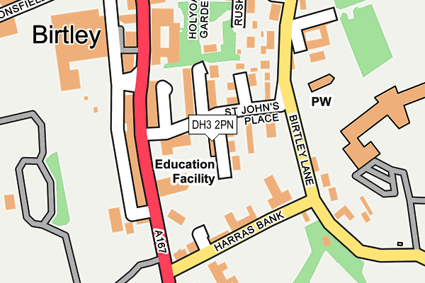
DH3 2PN is located in the Birtley electoral ward, within the metropolitan district of Gateshead and the English Parliamentary constituency of Blaydon. The Sub Integrated Care Board (ICB) Location is NHS North East and North Cumbria ICB - 13T and the police force is Northumbria. This postcode has been in use since January 1980.


GetTheData
Source: OS OpenMap – Local (Ordnance Survey)
Source: OS VectorMap District (Ordnance Survey)
Licence: Open Government Licence (requires attribution)
| Easting | 427288 |
| Northing | 555534 |
| Latitude | 54.893803 |
| Longitude | -1.576078 |
GetTheData
Source: Open Postcode Geo
Licence: Open Government Licence
| Country | England |
| Postcode District | DH3 |
| ➜ DH3 open data dashboard ➜ See where DH3 is on a map ➜ Where is Birtley? | |
GetTheData
Source: Land Registry Price Paid Data
Licence: Open Government Licence
Elevation or altitude of DH3 2PN as distance above sea level:
| Metres | Feet | |
|---|---|---|
| Elevation | 50m | 164ft |
Elevation is measured from the approximate centre of the postcode, to the nearest point on an OS contour line from OS Terrain 50, which has contour spacing of ten vertical metres.
➜ How high above sea level am I? Find the elevation of your current position using your device's GPS.
GetTheData
Source: Open Postcode Elevation
Licence: Open Government Licence
| Ward | Birtley |
| Constituency | Blaydon |
GetTheData
Source: ONS Postcode Database
Licence: Open Government Licence
| June 2022 | Criminal damage and arson | On or near St John'S Place | 82m |
| June 2022 | Vehicle crime | On or near Pedestrian Subway | 132m |
| June 2022 | Shoplifting | On or near Supermarket | 173m |
| ➜ Get more crime data in our Crime section | |||
GetTheData
Source: data.police.uk
Licence: Open Government Licence
| St Joseph's J And I School Birtley (School Street) | Birtley | 58m |
| Birtley Lane-harras Bank (Birtley Lane) | Birtley | 133m |
| Harras Bank | Birtley | 139m |
| Durham Road-harras Terrace (A167) | Birtley | 151m |
| Durham Road-co-op (Durham Road) | Birtley | 182m |
| Chester-le-Street Station | 4.4km |
GetTheData
Source: NaPTAN
Licence: Open Government Licence
GetTheData
Source: ONS Postcode Database
Licence: Open Government Licence


➜ Get more ratings from the Food Standards Agency
GetTheData
Source: Food Standards Agency
Licence: FSA terms & conditions
| Last Collection | |||
|---|---|---|---|
| Location | Mon-Fri | Sat | Distance |
| Harras Bank | 17:30 | 12:00 | 127m |
| Town Centre, Birtley | 17:30 | 12:00 | 253m |
| Newtown, Durham Rd, Birtley | 17:30 | 12:00 | 604m |
GetTheData
Source: Dracos
Licence: Creative Commons Attribution-ShareAlike
| Facility | Distance |
|---|---|
| St Josephs Rc Junior School School Street, Birtley, Chester Le Street Grass Pitches | 0m |
| Pulse Fitness (Closed) Harraton Terrace, Durham Road, Birtley, Chester Le Street Health and Fitness Gym, Studio | 113m |
| Birtley Gym And Fitness Centre Co-op Buildings, Durham Road, Birtley, Chester Le Street Health and Fitness Gym, Studio | 155m |
GetTheData
Source: Active Places
Licence: Open Government Licence
| School | Phase of Education | Distance |
|---|---|---|
| St Joseph's Catholic Junior School, Birtley School Street, Birtley, Chester le Street, DH3 2PN | Primary | 5m |
| Lord Lawson of Beamish Academy Birtley Lane, Birtley, Chester le Street, DH3 2LP | Secondary | 376m |
| St Joseph's Catholic Infant School, Birtley Mitchell Street, Birtley, Chester le Street, DH3 1LU | Primary | 585m |
GetTheData
Source: Edubase
Licence: Open Government Licence
The below table lists the International Territorial Level (ITL) codes (formerly Nomenclature of Territorial Units for Statistics (NUTS) codes) and Local Administrative Units (LAU) codes for DH3 2PN:
| ITL 1 Code | Name |
|---|---|
| TLC | North East (England) |
| ITL 2 Code | Name |
| TLC2 | Northumberland, and Tyne and Wear |
| ITL 3 Code | Name |
| TLC22 | Tyneside |
| LAU 1 Code | Name |
| E08000037 | Gateshead |
GetTheData
Source: ONS Postcode Directory
Licence: Open Government Licence
The below table lists the Census Output Area (OA), Lower Layer Super Output Area (LSOA), and Middle Layer Super Output Area (MSOA) for DH3 2PN:
| Code | Name | |
|---|---|---|
| OA | E00041422 | |
| LSOA | E01008174 | Gateshead 026C |
| MSOA | E02001707 | Gateshead 026 |
GetTheData
Source: ONS Postcode Directory
Licence: Open Government Licence
| DH3 2PW | St Johns Place | 73m |
| DH3 2PG | Arndale Houses | 98m |
| DH3 2PL | Church View | 106m |
| DH3 2QG | Harraton Terrace | 113m |
| DH3 2QF | Frank Place | 144m |
| DH3 2PJ | Birtley Lane | 159m |
| DH3 2LN | Harras Bank | 162m |
| DH3 2LW | Peareth Terrace | 170m |
| DH3 2QH | Durham Road | 210m |
| DH3 1AD | Ruskin Road | 217m |
GetTheData
Source: Open Postcode Geo; Land Registry Price Paid Data
Licence: Open Government Licence