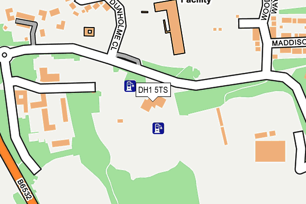
DH1 5TS is located in the Neville's Cross electoral ward, within the unitary authority of County Durham and the English Parliamentary constituency of City of Durham. The Sub Integrated Care Board (ICB) Location is NHS North East and North Cumbria ICB - 84H and the police force is Durham. This postcode has been in use since January 1980.


GetTheData
Source: OS OpenMap – Local (Ordnance Survey)
Source: OS VectorMap District (Ordnance Survey)
Licence: Open Government Licence (requires attribution)
| Easting | 426774 |
| Northing | 543842 |
| Latitude | 54.788774 |
| Longitude | -1.585180 |
GetTheData
Source: Open Postcode Geo
Licence: Open Government Licence
| Country | England |
| Postcode District | DH1 |
| ➜ DH1 open data dashboard ➜ See where DH1 is on a map ➜ Where is Durham? | |
GetTheData
Source: Land Registry Price Paid Data
Licence: Open Government Licence
Elevation or altitude of DH1 5TS as distance above sea level:
| Metres | Feet | |
|---|---|---|
| Elevation | 90m | 295ft |
Elevation is measured from the approximate centre of the postcode, to the nearest point on an OS contour line from OS Terrain 50, which has contour spacing of ten vertical metres.
➜ How high above sea level am I? Find the elevation of your current position using your device's GPS.
GetTheData
Source: Open Postcode Elevation
Licence: Open Government Licence
| Ward | Neville's Cross |
| Constituency | City Of Durham |
GetTheData
Source: ONS Postcode Database
Licence: Open Government Licence
| June 2022 | Criminal damage and arson | On or near Police Station | 200m |
| June 2022 | Anti-social behaviour | On or near Police Station | 200m |
| June 2022 | Criminal damage and arson | On or near Aykley Vale | 306m |
| ➜ Get more crime data in our Crime section | |||
GetTheData
Source: data.police.uk
Licence: Open Government Licence
| Dryburn Hospital - Old Entrance (B6532) | Durham | 307m |
| Dryburn Hospital - Old Entrance (B6532) | Durham | 315m |
| Aykley Heads - For University Hospital (B6532) | Durham | 327m |
| Aykley Heads - For University Hospital (B6532) | Durham | 361m |
| County Hall (B6532) | Durham | 369m |
| Durham Station | 1.1km |
GetTheData
Source: NaPTAN
Licence: Open Government Licence
GetTheData
Source: ONS Postcode Database
Licence: Open Government Licence


➜ Get more ratings from the Food Standards Agency
GetTheData
Source: Food Standards Agency
Licence: FSA terms & conditions
| Last Collection | |||
|---|---|---|---|
| Location | Mon-Fri | Sat | Distance |
| North End | 17:15 | 12:00 | 539m |
| Durham Moor Crescent | 17:15 | 12:00 | 625m |
| Framwellgate Moor Post Office | 17:30 | 12:00 | 699m |
GetTheData
Source: Dracos
Licence: Creative Commons Attribution-ShareAlike
| Facility | Distance |
|---|---|
| Durham Trinity School Aykley Heads Road, Aykley Heads Grass Pitches, Sports Hall | 129m |
| Aykley Heads Sports Centre (Closed) Aykley Heads, Durham Health and Fitness Gym, Swimming Pool, Grass Pitches, Studio, Squash Courts | 200m |
| Durham Moor Tennis Club Durham Moor Crescent, Framwellgate Moor Outdoor Tennis Courts | 464m |
GetTheData
Source: Active Places
Licence: Open Government Licence
| School | Phase of Education | Distance |
|---|---|---|
| Durham Trinity School & Sports College Dunholme Close, Aykley Heads, Durham, DH1 5WB | Not applicable | 154m |
| St Leonard's Catholic School, Durham North End, Durham, DH1 4NG | Secondary | 592m |
| Framwellgate Moor Primary School Newton Drive, Framwellgate Moor, Durham, DH1 5BG | Primary | 871m |
GetTheData
Source: Edubase
Licence: Open Government Licence
The below table lists the International Territorial Level (ITL) codes (formerly Nomenclature of Territorial Units for Statistics (NUTS) codes) and Local Administrative Units (LAU) codes for DH1 5TS:
| ITL 1 Code | Name |
|---|---|
| TLC | North East (England) |
| ITL 2 Code | Name |
| TLC1 | Tees Valley and Durham |
| ITL 3 Code | Name |
| TLC14 | Durham |
| LAU 1 Code | Name |
| E06000047 | County Durham |
GetTheData
Source: ONS Postcode Directory
Licence: Open Government Licence
The below table lists the Census Output Area (OA), Lower Layer Super Output Area (LSOA), and Middle Layer Super Output Area (MSOA) for DH1 5TS:
| Code | Name | |
|---|---|---|
| OA | E00171872 | |
| LSOA | E01020702 | County Durham 033B |
| MSOA | E02004315 | County Durham 033 |
GetTheData
Source: ONS Postcode Directory
Licence: Open Government Licence
| DH1 5WB | Dunholme Close | 218m |
| DH1 5AN | 290m | |
| DH1 5WA | Aykley Vale | 348m |
| DH1 5JB | Lilac Avenue | 357m |
| DH1 5US | Boste Crescent | 365m |
| DH1 5SE | Old Dryburn Way | 420m |
| DH1 5AL | Durham Road | 428m |
| DH1 5JP | High Carr Close | 435m |
| DH1 5JD | Lilac Avenue | 445m |
| DH1 5AT | High Carr Road | 450m |
GetTheData
Source: Open Postcode Geo; Land Registry Price Paid Data
Licence: Open Government Licence