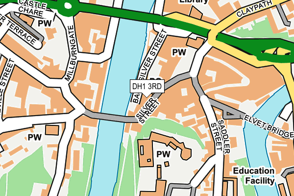
DH1 3RD is located in the Elvet and Gilesgate electoral ward, within the unitary authority of County Durham and the English Parliamentary constituency of City of Durham. The Sub Integrated Care Board (ICB) Location is NHS North East and North Cumbria ICB - 84H and the police force is Durham. This postcode has been in use since January 1980.


GetTheData
Source: OS OpenMap – Local (Ordnance Survey)
Source: OS VectorMap District (Ordnance Survey)
Licence: Open Government Licence (requires attribution)
| Easting | 427316 |
| Northing | 542470 |
| Latitude | 54.776406 |
| Longitude | -1.576870 |
GetTheData
Source: Open Postcode Geo
Licence: Open Government Licence
| Country | England |
| Postcode District | DH1 |
| ➜ DH1 open data dashboard ➜ See where DH1 is on a map ➜ Where is Durham? | |
GetTheData
Source: Land Registry Price Paid Data
Licence: Open Government Licence
Elevation or altitude of DH1 3RD as distance above sea level:
| Metres | Feet | |
|---|---|---|
| Elevation | 40m | 131ft |
Elevation is measured from the approximate centre of the postcode, to the nearest point on an OS contour line from OS Terrain 50, which has contour spacing of ten vertical metres.
➜ How high above sea level am I? Find the elevation of your current position using your device's GPS.
GetTheData
Source: Open Postcode Elevation
Licence: Open Government Licence
| Ward | Elvet And Gilesgate |
| Constituency | City Of Durham |
GetTheData
Source: ONS Postcode Database
Licence: Open Government Licence
| January 2024 | Shoplifting | On or near Back Silver Street | 68m |
| January 2024 | Anti-social behaviour | On or near Parking Area | 128m |
| January 2024 | Anti-social behaviour | On or near Parking Area | 128m |
| ➜ Get more crime data in our Crime section | |||
GetTheData
Source: data.police.uk
Licence: Open Government Licence
| Market Place | Durham | 125m |
| Market Place | Durham | 128m |
| Leazes Road - Millburngate Br (Leazes Road) | Durham | 156m |
| Millburngate Stand A (Milburngate) | Durham | 174m |
| Millburngate Stand B (Milburngate) | Durham | 181m |
| Durham Station | 0.5km |
GetTheData
Source: NaPTAN
Licence: Open Government Licence
➜ Broadband speed and availability dashboard for DH1 3RD
| Median download speed | 21.8Mbps |
| Average download speed | 35.8Mbps |
| Maximum download speed | 77.62Mbps |
| Median upload speed | 1.2Mbps |
| Average upload speed | 6.4Mbps |
| Maximum upload speed | 20.00Mbps |
➜ Broadband speed and availability dashboard for DH1 3RD
GetTheData
Source: Ofcom
Licence: Ofcom Terms of Use (requires attribution)
GetTheData
Source: ONS Postcode Database
Licence: Open Government Licence


➜ Get more ratings from the Food Standards Agency
GetTheData
Source: Food Standards Agency
Licence: FSA terms & conditions
| Last Collection | |||
|---|---|---|---|
| Location | Mon-Fri | Sat | Distance |
| Silver Street | 18:30 | 12:30 | 19m |
| Market Place | 18:30 | 12:00 | 116m |
| Milburngate | 17:30 | 12:00 | 171m |
GetTheData
Source: Dracos
Licence: Creative Commons Attribution-ShareAlike
| Facility | Distance |
|---|---|
| Result Fitness Gym The Riverwalk, Durham Health and Fitness Gym, Studio | 149m |
| Shakespeare Hall (Durham Community Association) North Road, Durham Sports Hall | 250m |
| Meridian Health & Fitness (Closed) Walkergate, Durham Studio, Swimming Pool, Health and Fitness Gym | 291m |
GetTheData
Source: Active Places
Licence: Open Government Licence
| School | Phase of Education | Distance |
|---|---|---|
| The Independent Grammar School:Durham Claypath, Durham, DH1 1RH | Not applicable | 336m |
| Durham Sixth Form Centre Providence Row, The Sands, Durham, DH1 1SG | 16 plus | 484m |
| University of Durham University Office, Old Evet, Durham, DH1 3HP | Not applicable | 487m |
GetTheData
Source: Edubase
Licence: Open Government Licence
The below table lists the International Territorial Level (ITL) codes (formerly Nomenclature of Territorial Units for Statistics (NUTS) codes) and Local Administrative Units (LAU) codes for DH1 3RD:
| ITL 1 Code | Name |
|---|---|
| TLC | North East (England) |
| ITL 2 Code | Name |
| TLC1 | Tees Valley and Durham |
| ITL 3 Code | Name |
| TLC14 | Durham |
| LAU 1 Code | Name |
| E06000047 | County Durham |
GetTheData
Source: ONS Postcode Directory
Licence: Open Government Licence
The below table lists the Census Output Area (OA), Lower Layer Super Output Area (LSOA), and Middle Layer Super Output Area (MSOA) for DH1 3RD:
| Code | Name | |
|---|---|---|
| OA | E00171795 | |
| LSOA | E01033164 | County Durham 030D |
| MSOA | E02004314 | County Durham 030 |
GetTheData
Source: ONS Postcode Directory
Licence: Open Government Licence
| DH1 4SW | Lambton Walk | 97m |
| DH1 3NP | Saddler Street | 106m |
| DH1 3RP | Back Silver Street | 118m |
| DH1 4DB | St Helens Well | 154m |
| DH1 3AA | Elvet Bridge | 156m |
| DH1 3NU | Saddler Street | 159m |
| DH1 4QX | Dunelm Court | 200m |
| DH1 4SH | North Road | 207m |
| DH1 4PR | Crossgate | 223m |
| DH1 4TZ | St Annes Court | 234m |
GetTheData
Source: Open Postcode Geo; Land Registry Price Paid Data
Licence: Open Government Licence