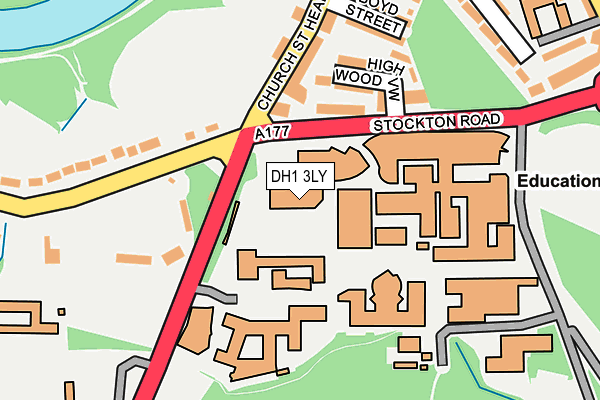
DH1 3LY is located in the Durham South electoral ward, within the unitary authority of County Durham and the English Parliamentary constituency of City of Durham. The Sub Integrated Care Board (ICB) Location is NHS North East and North Cumbria ICB - 84H and the police force is Durham. This postcode has been in use since July 1983.


GetTheData
Source: OS OpenMap – Local (Ordnance Survey)
Source: OS VectorMap District (Ordnance Survey)
Licence: Open Government Licence (requires attribution)
| Easting | 427550 |
| Northing | 541553 |
| Latitude | 54.768153 |
| Longitude | -1.573319 |
GetTheData
Source: Open Postcode Geo
Licence: Open Government Licence
| Country | England |
| Postcode District | DH1 |
| ➜ DH1 open data dashboard ➜ See where DH1 is on a map ➜ Where is Durham? | |
GetTheData
Source: Land Registry Price Paid Data
Licence: Open Government Licence
Elevation or altitude of DH1 3LY as distance above sea level:
| Metres | Feet | |
|---|---|---|
| Elevation | 60m | 197ft |
Elevation is measured from the approximate centre of the postcode, to the nearest point on an OS contour line from OS Terrain 50, which has contour spacing of ten vertical metres.
➜ How high above sea level am I? Find the elevation of your current position using your device's GPS.
GetTheData
Source: Open Postcode Elevation
Licence: Open Government Licence
| Ward | Durham South |
| Constituency | City Of Durham |
GetTheData
Source: ONS Postcode Database
Licence: Open Government Licence
| June 2022 | Anti-social behaviour | On or near High Wood View | 139m |
| June 2022 | Anti-social behaviour | On or near High Wood View | 139m |
| June 2022 | Other theft | On or near Church Street Head | 142m |
| ➜ Get more crime data in our Crime section | |||
GetTheData
Source: data.police.uk
Licence: Open Government Licence
| New Inn - Quarryheads Lane (Quarryheads Lane) | Durham | 127m |
| New Inn - Church Street (Church Street) | Durham | 136m |
| New Inn - Church Street (Church Street) | Durham | 138m |
| New Inn - Quarryheads Lane (Quarryheads Lane) | Durham | 142m |
| University - Palatine Centre (A177 - Stockton Road) | Durham | 197m |
| Durham Station | 1.4km |
GetTheData
Source: NaPTAN
Licence: Open Government Licence
GetTheData
Source: ONS Postcode Database
Licence: Open Government Licence


➜ Get more ratings from the Food Standards Agency
GetTheData
Source: Food Standards Agency
Licence: FSA terms & conditions
| Last Collection | |||
|---|---|---|---|
| Location | Mon-Fri | Sat | Distance |
| Boyd Street | 17:30 | 11:30 | 207m |
| Science Labs | 17:15 | 12:00 | 213m |
| Hallgarth Street | 17:30 | 11:30 | 347m |
GetTheData
Source: Dracos
Licence: Creative Commons Attribution-ShareAlike
| Facility | Distance |
|---|---|
| The Chorister School (Church Street Head Pitches) Church Street Head, Durham Grass Pitches | 144m |
| The Chorister School (Quarryheads Lane Pitches) Quarryheads Lane, Durham Grass Pitches | 453m |
| The Chorister School The College, Durham Sports Hall | 519m |
GetTheData
Source: Active Places
Licence: Open Government Licence
| School | Phase of Education | Distance |
|---|---|---|
| St Oswald's Church of England Aided Primary and Nursery School Church Street, Durham, DH1 3DQ | Primary | 328m |
| Durham Cathedral Schools Foundation Durham Cathedral Schools Foundation, Quarryheads Lane, Durham, DH1 4SZ | Not applicable | 696m |
| University of Durham University Office, Old Evet, Durham, DH1 3HP | Not applicable | 788m |
GetTheData
Source: Edubase
Licence: Open Government Licence
The below table lists the International Territorial Level (ITL) codes (formerly Nomenclature of Territorial Units for Statistics (NUTS) codes) and Local Administrative Units (LAU) codes for DH1 3LY:
| ITL 1 Code | Name |
|---|---|
| TLC | North East (England) |
| ITL 2 Code | Name |
| TLC1 | Tees Valley and Durham |
| ITL 3 Code | Name |
| TLC14 | Durham |
| LAU 1 Code | Name |
| E06000047 | County Durham |
GetTheData
Source: ONS Postcode Directory
Licence: Open Government Licence
The below table lists the Census Output Area (OA), Lower Layer Super Output Area (LSOA), and Middle Layer Super Output Area (MSOA) for DH1 3LY:
| Code | Name | |
|---|---|---|
| OA | E00105080 | |
| LSOA | E01033221 | County Durham 030G |
| MSOA | E02004314 | County Durham 030 |
GetTheData
Source: ONS Postcode Directory
Licence: Open Government Licence
| DH1 3DR | Union Place | 101m |
| DH1 3DS | High Wood Terrace | 110m |
| DH1 3DT | High Wood View | 126m |
| DH1 3DN | Church Street Head | 138m |
| DH1 3DU | Gladstone Villas | 151m |
| DH1 3DW | Church Street Villas | 192m |
| DH1 3DP | Boyd Street | 206m |
| DH1 3DL | Anchorage Terrace | 258m |
| DH1 3DJ | Oswald Court | 282m |
| DH1 3DY | Quarryheads Lane | 288m |
GetTheData
Source: Open Postcode Geo; Land Registry Price Paid Data
Licence: Open Government Licence