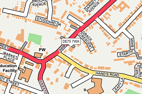
DE75 7WH is located in the Heanor East electoral ward, within the local authority district of Amber Valley and the English Parliamentary constituency of Amber Valley. The Sub Integrated Care Board (ICB) Location is NHS Derby and Derbyshire ICB - 15M and the police force is Derbyshire. This postcode has been in use since May 2014.


GetTheData
Source: OS OpenMap – Local (Ordnance Survey)
Source: OS VectorMap District (Ordnance Survey)
Licence: Open Government Licence (requires attribution)
| Easting | 443724 |
| Northing | 346474 |
| Latitude | 53.013792 |
| Longitude | -1.349733 |
GetTheData
Source: Open Postcode Geo
Licence: Open Government Licence
| Country | England |
| Postcode District | DE75 |
| ➜ DE75 open data dashboard ➜ See where DE75 is on a map ➜ Where is Heanor? | |
GetTheData
Source: Land Registry Price Paid Data
Licence: Open Government Licence
Elevation or altitude of DE75 7WH as distance above sea level:
| Metres | Feet | |
|---|---|---|
| Elevation | 110m | 361ft |
Elevation is measured from the approximate centre of the postcode, to the nearest point on an OS contour line from OS Terrain 50, which has contour spacing of ten vertical metres.
➜ How high above sea level am I? Find the elevation of your current position using your device's GPS.
GetTheData
Source: Open Postcode Elevation
Licence: Open Government Licence
| Ward | Heanor East |
| Constituency | Amber Valley |
GetTheData
Source: ONS Postcode Database
Licence: Open Government Licence
| July 2023 | Vehicle crime | On or near Saxton Avenue | 367m |
| June 2022 | Violence and sexual offences | On or near Church Street | 53m |
| June 2022 | Violence and sexual offences | On or near Church Street | 53m |
| ➜ Get more crime data in our Crime section | |||
GetTheData
Source: data.police.uk
Licence: Open Government Licence
| Hands Road (Church Street) | Heanor | 29m |
| Vicarage Gardens (Hands Road) | Heanor | 57m |
| Vicarage Gardens (Hands Road) | Heanor | 110m |
| The Crown Ph (Ilkeston Road) | Heanor | 174m |
| Church (Market Street) | Heanor | 198m |
| Langley Mill Station | 1.3km |
| Ilkeston Station | 5.3km |
GetTheData
Source: NaPTAN
Licence: Open Government Licence
GetTheData
Source: ONS Postcode Database
Licence: Open Government Licence


➜ Get more ratings from the Food Standards Agency
GetTheData
Source: Food Standards Agency
Licence: FSA terms & conditions
| Last Collection | |||
|---|---|---|---|
| Location | Mon-Fri | Sat | Distance |
| Heanor Road | 17:30 | 09:00 | 24m |
| Heanor Main Post Office | 18:30 | 12:00 | 345m |
| Heanor Main Post Office | 18:30 | 12:00 | 345m |
GetTheData
Source: Dracos
Licence: Creative Commons Attribution-ShareAlike
| Facility | Distance |
|---|---|
| William Gregg Vc Leisure Centre Hands Road, Heanor Sports Hall, Swimming Pool, Health and Fitness Gym, Studio | 190m |
| Heanor Miners Welfare Trust Ilkeston Road, Heanor Grass Pitches | 280m |
| Puregym (Heanor) High Street, Heanor Health and Fitness Gym | 502m |
GetTheData
Source: Active Places
Licence: Open Government Licence
| School | Phase of Education | Distance |
|---|---|---|
| Jasmine House School Jasmine House School, 34 Ilkeston Road, Heanor, Derbyshire, DE75 7DT | Not applicable | 267m |
| Mundy CofE Junior School Lockton Avenue, Heanor, DE75 7EQ | Primary | 612m |
| Marlpool Infant School Prospect Road, Marlpool, Heanor, DE75 7NF | Primary | 744m |
GetTheData
Source: Edubase
Licence: Open Government Licence
The below table lists the International Territorial Level (ITL) codes (formerly Nomenclature of Territorial Units for Statistics (NUTS) codes) and Local Administrative Units (LAU) codes for DE75 7WH:
| ITL 1 Code | Name |
|---|---|
| TLF | East Midlands (England) |
| ITL 2 Code | Name |
| TLF1 | Derbyshire and Nottinghamshire |
| ITL 3 Code | Name |
| TLF13 | South and West Derbyshire |
| LAU 1 Code | Name |
| E07000032 | Amber Valley |
GetTheData
Source: ONS Postcode Directory
Licence: Open Government Licence
The below table lists the Census Output Area (OA), Lower Layer Super Output Area (LSOA), and Middle Layer Super Output Area (MSOA) for DE75 7WH:
| Code | Name | |
|---|---|---|
| OA | E00098325 | |
| LSOA | E01019440 | Amber Valley 013E |
| MSOA | E02004041 | Amber Valley 013 |
GetTheData
Source: ONS Postcode Directory
Licence: Open Government Licence
| DE75 7AH | Church Street | 33m |
| DE75 7AP | Grace Crescent | 65m |
| DE75 7HA | Hands Road | 80m |
| DE75 7AN | St Lawrence Close | 105m |
| DE75 7ST | Stoddard Drive | 168m |
| DE75 7AJ | Mansfield Road | 173m |
| DE75 7AS | Garnett Avenue | 207m |
| DE75 7AW | Howitt Street | 227m |
| DE75 7AX | Starthe Bank | 233m |
| DE75 7AA | Market Place | 243m |
GetTheData
Source: Open Postcode Geo; Land Registry Price Paid Data
Licence: Open Government Licence