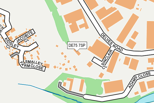
DE75 7SP is located in the Smalley, Shipley & Horsley Woodhouse electoral ward, within the local authority district of Amber Valley and the English Parliamentary constituency of Amber Valley. The Sub Integrated Care Board (ICB) Location is NHS Derby and Derbyshire ICB - 15M and the police force is Derbyshire. This postcode has been in use since August 1992.


GetTheData
Source: OS OpenMap – Local (Ordnance Survey)
Source: OS VectorMap District (Ordnance Survey)
Licence: Open Government Licence (requires attribution)
| Easting | 442607 |
| Northing | 345593 |
| Latitude | 53.005982 |
| Longitude | -1.366494 |
GetTheData
Source: Open Postcode Geo
Licence: Open Government Licence
| Country | England |
| Postcode District | DE75 |
| ➜ DE75 open data dashboard ➜ See where DE75 is on a map ➜ Where is Heanor? | |
GetTheData
Source: Land Registry Price Paid Data
Licence: Open Government Licence
Elevation or altitude of DE75 7SP as distance above sea level:
| Metres | Feet | |
|---|---|---|
| Elevation | 110m | 361ft |
Elevation is measured from the approximate centre of the postcode, to the nearest point on an OS contour line from OS Terrain 50, which has contour spacing of ten vertical metres.
➜ How high above sea level am I? Find the elevation of your current position using your device's GPS.
GetTheData
Source: Open Postcode Elevation
Licence: Open Government Licence
| Ward | Smalley, Shipley & Horsley Woodhouse |
| Constituency | Amber Valley |
GetTheData
Source: ONS Postcode Database
Licence: Open Government Licence
| June 2022 | Violence and sexual offences | On or near Delves Road | 166m |
| June 2022 | Violence and sexual offences | On or near Delves Road | 166m |
| June 2022 | Violence and sexual offences | On or near Barnes Croft | 436m |
| ➜ Get more crime data in our Crime section | |||
GetTheData
Source: data.police.uk
Licence: Open Government Licence
| Kirkley Drive (Heanor Road) | Heanor Gate | 514m |
| Kirkley Drive (Heanor Road) | Heanor Gate | 546m |
| Peatburn Avenue (Heanor Road) | Heanor Gate | 555m |
| Mayfield Avenue (Burnt House Road) | Heanor | 620m |
| Heanor Gate College (Kirkley Drive) | Heanor Gate | 620m |
| Langley Mill Station | 2.7km |
| Ilkeston Station | 5.6km |
GetTheData
Source: NaPTAN
Licence: Open Government Licence
GetTheData
Source: ONS Postcode Database
Licence: Open Government Licence


➜ Get more ratings from the Food Standards Agency
GetTheData
Source: Food Standards Agency
Licence: FSA terms & conditions
| Last Collection | |||
|---|---|---|---|
| Location | Mon-Fri | Sat | Distance |
| Heanor Gate Business Box | 18:30 | 418m | |
| Heanor Gate Road | 17:30 | 09:00 | 513m |
| Burnthouse Road | 17:30 | 08:30 | 642m |
GetTheData
Source: Dracos
Licence: Creative Commons Attribution-ShareAlike
| Facility | Distance |
|---|---|
| Heanor Fitness Centre (Closed) Heanor Gate Industrial Estate, Heanor Gate Road, Heanor Health and Fitness Gym, Studio | 404m |
| Heanor Gate Science College Kirkley Drive, Heanor Grass Pitches, Sports Hall | 638m |
| Lockton Avenue Recreation Ground Lockton Avenue, Heanor Grass Pitches | 719m |
GetTheData
Source: Active Places
Licence: Open Government Licence
| School | Phase of Education | Distance |
|---|---|---|
| Heanor Gate Spencer Academy Kirkley Drive, Heanor, DE75 7RA | Secondary | 638m |
| Corfield CofE Infant School Thorpes Road, Heanor, DE75 7GQ | Primary | 692m |
| Coppice Primary School Roper Avenue, Marlpool, Heanor, DE75 7BZ | Primary | 812m |
GetTheData
Source: Edubase
Licence: Open Government Licence
The below table lists the International Territorial Level (ITL) codes (formerly Nomenclature of Territorial Units for Statistics (NUTS) codes) and Local Administrative Units (LAU) codes for DE75 7SP:
| ITL 1 Code | Name |
|---|---|
| TLF | East Midlands (England) |
| ITL 2 Code | Name |
| TLF1 | Derbyshire and Nottinghamshire |
| ITL 3 Code | Name |
| TLF13 | South and West Derbyshire |
| LAU 1 Code | Name |
| E07000032 | Amber Valley |
GetTheData
Source: ONS Postcode Directory
Licence: Open Government Licence
The below table lists the Census Output Area (OA), Lower Layer Super Output Area (LSOA), and Middle Layer Super Output Area (MSOA) for DE75 7SP:
| Code | Name | |
|---|---|---|
| OA | E00098452 | |
| LSOA | E01019464 | Amber Valley 012E |
| MSOA | E02004040 | Amber Valley 012 |
GetTheData
Source: ONS Postcode Directory
Licence: Open Government Licence
| DE7 6NW | Smalley Manor Drive | 349m |
| DE75 7SY | Barnes Croft | 390m |
| DE75 7RZ | Twyford Close | 412m |
| DE7 6LZ | Lowe Avenue | 413m |
| DE75 7QZ | Heanor Gate | 481m |
| DE75 7GX | Slack Lane | 482m |
| DE7 6DP | The Beeches | 524m |
| DE75 7GU | Peach Street | 532m |
| DE7 6JZ | The Grange | 548m |
| DE7 6PH | Meadow Drive | 549m |
GetTheData
Source: Open Postcode Geo; Land Registry Price Paid Data
Licence: Open Government Licence