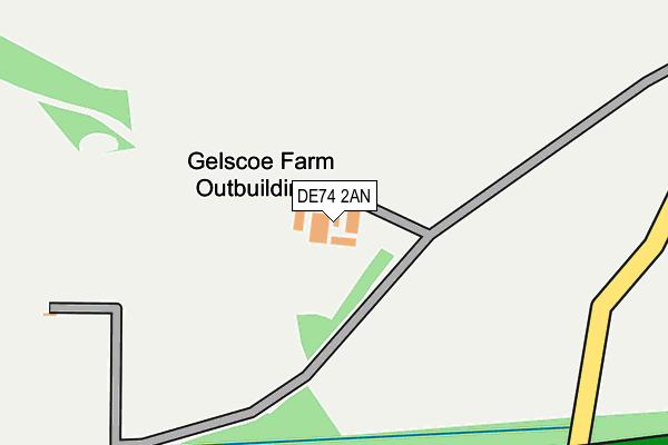
DE74 2AN is located in the Worthington & Breedon electoral ward, within the local authority district of North West Leicestershire and the English Parliamentary constituency of North West Leicestershire. The Sub Integrated Care Board (ICB) Location is NHS Leicester, Leicestershire and Rutland ICB - 04V and the police force is Leicestershire. This postcode has been in use since September 2016.


GetTheData
Source: OS OpenMap – Local (Ordnance Survey)
Source: OS VectorMap District (Ordnance Survey)
Licence: Open Government Licence (requires attribution)
| Easting | 443482 |
| Northing | 322689 |
| Latitude | 52.800033 |
| Longitude | -1.356507 |
GetTheData
Source: Open Postcode Geo
Licence: Open Government Licence
| Country | England |
| Postcode District | DE74 |
| ➜ DE74 open data dashboard ➜ See where DE74 is on a map | |
GetTheData
Source: Land Registry Price Paid Data
Licence: Open Government Licence
Elevation or altitude of DE74 2AN as distance above sea level:
| Metres | Feet | |
|---|---|---|
| Elevation | 90m | 295ft |
Elevation is measured from the approximate centre of the postcode, to the nearest point on an OS contour line from OS Terrain 50, which has contour spacing of ten vertical metres.
➜ How high above sea level am I? Find the elevation of your current position using your device's GPS.
GetTheData
Source: Open Postcode Elevation
Licence: Open Government Licence
| Ward | Worthington & Breedon |
| Constituency | North West Leicestershire |
GetTheData
Source: ONS Postcode Database
Licence: Open Government Licence
| May 2022 | Other theft | On or near A42 | 306m |
| December 2021 | Criminal damage and arson | On or near A42 | 306m |
| December 2021 | Other theft | On or near A42 | 306m |
| ➜ Get more crime data in our Crime section | |||
GetTheData
Source: data.police.uk
Licence: Open Government Licence
GetTheData
Source: ONS Postcode Database
Licence: Open Government Licence

➜ Get more ratings from the Food Standards Agency
GetTheData
Source: Food Standards Agency
Licence: FSA terms & conditions
| Last Collection | |||
|---|---|---|---|
| Location | Mon-Fri | Sat | Distance |
| Tonge Village | 16:00 | 10:30 | 1,786m |
| The Woodcroft | 17:00 | 10:30 | 2,226m |
| Belton Post Office | 16:20 | 09:30 | 2,250m |
GetTheData
Source: Dracos
Licence: Creative Commons Attribution-ShareAlike
| Facility | Distance |
|---|---|
| Belton Recreation Ground Saddlers Wells, Belton, Loughborough Grass Pitches | 2.4km |
| Belton Church Of England Primary School Sadlers Wells, Belton, Loughborough Grass Pitches | 2.5km |
| St Hardulphs C Of E Primary School Main Street, Breedon-on-the-hill, Derby Grass Pitches | 2.7km |
GetTheData
Source: Active Places
Licence: Open Government Licence
| School | Phase of Education | Distance |
|---|---|---|
| Belton Church of England Primary School Sadlers Wells, Belton, Loughborough, LE12 9TS | Primary | 2.5km |
| Diseworth Church of England Primary School Grimesgate, Diseworth, Derby, DE74 2QD | Primary | 2.7km |
| St Hardulph's Church of England Primary School Main Street, Breedon-on-the-Hill, Derby, DE73 8AN | Primary | 2.9km |
GetTheData
Source: Edubase
Licence: Open Government Licence
The below table lists the International Territorial Level (ITL) codes (formerly Nomenclature of Territorial Units for Statistics (NUTS) codes) and Local Administrative Units (LAU) codes for DE74 2AN:
| ITL 1 Code | Name |
|---|---|
| TLF | East Midlands (England) |
| ITL 2 Code | Name |
| TLF2 | Leicestershire, Rutland and Northamptonshire |
| ITL 3 Code | Name |
| TLF22 | Leicestershire CC and Rutland |
| LAU 1 Code | Name |
| E07000134 | North West Leicestershire |
GetTheData
Source: ONS Postcode Directory
Licence: Open Government Licence
The below table lists the Census Output Area (OA), Lower Layer Super Output Area (LSOA), and Middle Layer Super Output Area (MSOA) for DE74 2AN:
| Code | Name | |
|---|---|---|
| OA | E00131556 | |
| LSOA | E01025924 | North West Leicestershire 001A |
| MSOA | E02005397 | North West Leicestershire 001 |
GetTheData
Source: ONS Postcode Directory
Licence: Open Government Licence
| DE74 2QQ | 835m | |
| DE73 8BB | Moor Lane | 1652m |
| DE73 8BD | 1657m | |
| DE73 8HG | Dovecote | 1740m |
| DE73 8BA | Breedon Lane | 1850m |
| LE12 9UJ | Mill Lane | 1935m |
| DE74 2TT | Tenterfield | 2163m |
| LE12 9UL | The Toft | 2175m |
| DE74 2QN | The Green | 2220m |
| LE12 9UH | Market Place | 2229m |
GetTheData
Source: Open Postcode Geo; Land Registry Price Paid Data
Licence: Open Government Licence