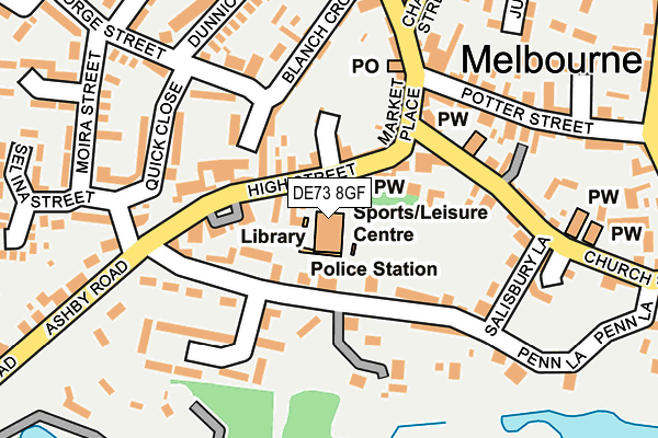
DE73 8GF is located in the Melbourne electoral ward, within the local authority district of South Derbyshire and the English Parliamentary constituency of South Derbyshire. The Sub Integrated Care Board (ICB) Location is NHS Derby and Derbyshire ICB - 15M and the police force is Derbyshire. This postcode has been in use since September 2004.


GetTheData
Source: OS OpenMap – Local (Ordnance Survey)
Source: OS VectorMap District (Ordnance Survey)
Licence: Open Government Licence (requires attribution)
| Easting | 438541 |
| Northing | 325114 |
| Latitude | 52.822188 |
| Longitude | -1.429510 |
GetTheData
Source: Open Postcode Geo
Licence: Open Government Licence
| Country | England |
| Postcode District | DE73 |
| ➜ DE73 open data dashboard ➜ See where DE73 is on a map ➜ Where is Melbourne? | |
GetTheData
Source: Land Registry Price Paid Data
Licence: Open Government Licence
Elevation or altitude of DE73 8GF as distance above sea level:
| Metres | Feet | |
|---|---|---|
| Elevation | 70m | 230ft |
Elevation is measured from the approximate centre of the postcode, to the nearest point on an OS contour line from OS Terrain 50, which has contour spacing of ten vertical metres.
➜ How high above sea level am I? Find the elevation of your current position using your device's GPS.
GetTheData
Source: Open Postcode Elevation
Licence: Open Government Licence
| Ward | Melbourne |
| Constituency | South Derbyshire |
GetTheData
Source: ONS Postcode Database
Licence: Open Government Licence
| December 2023 | Public order | On or near Parking Area | 109m |
| September 2023 | Other theft | On or near Parking Area | 109m |
| September 2023 | Violence and sexual offences | On or near Parking Area | 109m |
| ➜ Get more crime data in our Crime section | |||
GetTheData
Source: data.police.uk
Licence: Open Government Licence
| Market Place | Melbourne | 100m |
| Market Place (Church Street) | Melbourne | 113m |
| Market Place | Melbourne | 124m |
| Ashby Road (High Street) | Melbourne | 133m |
| Ashby Road | Melbourne | 187m |
GetTheData
Source: NaPTAN
Licence: Open Government Licence
GetTheData
Source: ONS Postcode Database
Licence: Open Government Licence


➜ Get more ratings from the Food Standards Agency
GetTheData
Source: Food Standards Agency
Licence: FSA terms & conditions
| Last Collection | |||
|---|---|---|---|
| Location | Mon-Fri | Sat | Distance |
| Melbourne So | 17:30 | 10:30 | 170m |
| Ashby Road (Melbourne) | 16:45 | 10:30 | 191m |
| Castle Square | 17:00 | 10:30 | 337m |
GetTheData
Source: Dracos
Licence: Creative Commons Attribution-ShareAlike
| Facility | Distance |
|---|---|
| Melbourne Assembly Rooms High Street, Melbourne, Derby Sports Hall, Squash Courts | 6m |
| Picture Of Health Fitness Studio (Derby) (Closed) Derby Road, Melbourne, Derby Health and Fitness Gym, Studio | 404m |
| Melbourne Sports Park Cockshut Lane, Melbourne, Derby Grass Pitches, Artificial Grass Pitch, Outdoor Tennis Courts | 512m |
GetTheData
Source: Active Places
Licence: Open Government Licence
| School | Phase of Education | Distance |
|---|---|---|
| Melbourne Junior School Packhorse Road, Melbourne, Derby, DE73 8JE | Primary | 594m |
| Melbourne Infant School Packhorse Road, Melbourne, Derby, DE73 8JE | Primary | 680m |
| St Hardulph's Church of England Primary School Main Street, Breedon-on-the-Hill, Derby, DE73 8AN | Primary | 3km |
GetTheData
Source: Edubase
Licence: Open Government Licence
The below table lists the International Territorial Level (ITL) codes (formerly Nomenclature of Territorial Units for Statistics (NUTS) codes) and Local Administrative Units (LAU) codes for DE73 8GF:
| ITL 1 Code | Name |
|---|---|
| TLF | East Midlands (England) |
| ITL 2 Code | Name |
| TLF1 | Derbyshire and Nottinghamshire |
| ITL 3 Code | Name |
| TLF13 | South and West Derbyshire |
| LAU 1 Code | Name |
| E07000039 | South Derbyshire |
GetTheData
Source: ONS Postcode Directory
Licence: Open Government Licence
The below table lists the Census Output Area (OA), Lower Layer Super Output Area (LSOA), and Middle Layer Super Output Area (MSOA) for DE73 8GF:
| Code | Name | |
|---|---|---|
| OA | E00100472 | |
| LSOA | E01019854 | South Derbyshire 006C |
| MSOA | E02004123 | South Derbyshire 006 |
GetTheData
Source: ONS Postcode Directory
Licence: Open Government Licence
| DE73 8GJ | High Street | 53m |
| DE73 8EQ | Penn Lane | 57m |
| DE73 8DS | Market Place | 105m |
| DE73 8GQ | Thomas Cook Close | 114m |
| DE73 8GG | Blanchcroft | 172m |
| DE73 8JL | George Street | 173m |
| DE73 8GH | Quick Close | 183m |
| DE73 8HX | Potters Yard | 184m |
| DE73 8LN | Bishops Court | 194m |
| DE73 8EJ | Church Street | 203m |
GetTheData
Source: Open Postcode Geo; Land Registry Price Paid Data
Licence: Open Government Licence