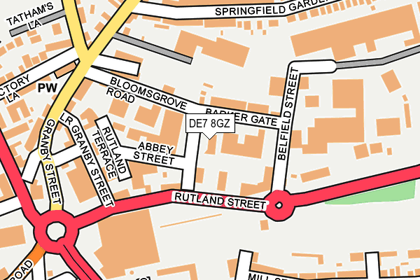
DE7 8GZ is located in the Awsworth Road electoral ward, within the local authority district of Erewash and the English Parliamentary constituency of Erewash. The Sub Integrated Care Board (ICB) Location is NHS Derby and Derbyshire ICB - 15M and the police force is Derbyshire. This postcode has been in use since January 2019.


GetTheData
Source: OS OpenMap – Local (Ordnance Survey)
Source: OS VectorMap District (Ordnance Survey)
Licence: Open Government Licence (requires attribution)
| Easting | 446654 |
| Northing | 342609 |
| Latitude | 52.978824 |
| Longitude | -1.306617 |
GetTheData
Source: Open Postcode Geo
Licence: Open Government Licence
| Country | England |
| Postcode District | DE7 |
| ➜ DE7 open data dashboard ➜ See where DE7 is on a map ➜ Where is Ilkeston? | |
GetTheData
Source: Land Registry Price Paid Data
Licence: Open Government Licence
Elevation or altitude of DE7 8GZ as distance above sea level:
| Metres | Feet | |
|---|---|---|
| Elevation | 60m | 197ft |
Elevation is measured from the approximate centre of the postcode, to the nearest point on an OS contour line from OS Terrain 50, which has contour spacing of ten vertical metres.
➜ How high above sea level am I? Find the elevation of your current position using your device's GPS.
GetTheData
Source: Open Postcode Elevation
Licence: Open Government Licence
| Ward | Awsworth Road |
| Constituency | Erewash |
GetTheData
Source: ONS Postcode Database
Licence: Open Government Licence
| January 2024 | Other crime | On or near Supermarket | 278m |
| January 2024 | Possession of weapons | On or near Supermarket | 278m |
| January 2024 | Public order | On or near Supermarket | 278m |
| ➜ Get more crime data in our Crime section | |||
GetTheData
Source: data.police.uk
Licence: Open Government Licence
| Tesco (Rutland Street) | Ilkeston | 115m |
| Bloomsgrove Road (Granby Street) | Ilkeston | 152m |
| Granby Street | Ilkeston | 178m |
| Granby Street | Ilkeston | 188m |
| Bloomsgrove Road (Cotmanhay Road) | Ilkeston | 206m |
| Ilkeston Station | 0.8km |
| Langley Mill Station | 4.7km |
GetTheData
Source: NaPTAN
Licence: Open Government Licence
GetTheData
Source: ONS Postcode Database
Licence: Open Government Licence


➜ Get more ratings from the Food Standards Agency
GetTheData
Source: Food Standards Agency
Licence: FSA terms & conditions
| Last Collection | |||
|---|---|---|---|
| Location | Mon-Fri | Sat | Distance |
| Barker Gate | 17:30 | 07:30 | 50m |
| Tesco | 17:30 | 10:30 | 141m |
| Awsworth Road | 17:30 | 07:30 | 355m |
GetTheData
Source: Dracos
Licence: Creative Commons Attribution-ShareAlike
| Facility | Distance |
|---|---|
| Curves (Ilkeston) Awsworth Road, Ilkeston Health and Fitness Gym | 122m |
| Anytime Fitness (Ilkeston) Rutland Street, Ilkeston Health and Fitness Gym, Studio | 145m |
| Platinum Gym And Fitness Awsworth Road, Ilkeston Health and Fitness Gym | 147m |
GetTheData
Source: Active Places
Licence: Open Government Licence
| School | Phase of Education | Distance |
|---|---|---|
| Charlotte Nursery and Infant School Trinity Close, Ilkeston, DE7 8LQ | Primary | 476m |
| Chaucer Junior School Cranmer Street, Ilkeston, DE7 5JH | Primary | 573m |
| Granby Junior School Heanor Road, Ilkeston, DE7 8DX | Primary | 650m |
GetTheData
Source: Edubase
Licence: Open Government Licence
The below table lists the International Territorial Level (ITL) codes (formerly Nomenclature of Territorial Units for Statistics (NUTS) codes) and Local Administrative Units (LAU) codes for DE7 8GZ:
| ITL 1 Code | Name |
|---|---|
| TLF | East Midlands (England) |
| ITL 2 Code | Name |
| TLF1 | Derbyshire and Nottinghamshire |
| ITL 3 Code | Name |
| TLF13 | South and West Derbyshire |
| LAU 1 Code | Name |
| E07000036 | Erewash |
GetTheData
Source: ONS Postcode Directory
Licence: Open Government Licence
The below table lists the Census Output Area (OA), Lower Layer Super Output Area (LSOA), and Middle Layer Super Output Area (MSOA) for DE7 8GZ:
| Code | Name | |
|---|---|---|
| OA | E00099475 | |
| LSOA | E01019661 | Erewash 003C |
| MSOA | E02004080 | Erewash 003 |
GetTheData
Source: ONS Postcode Directory
Licence: Open Government Licence
| DE7 8DG | Rutland Street | 83m |
| DE7 8DQ | Bloomsgrove Road | 84m |
| DE7 8DS | Barker Gate | 103m |
| DE7 8HW | Spring Garden Terrace | 106m |
| DE7 8HX | Awsworth Road | 126m |
| DE7 8DJ | Lower Granby Street | 144m |
| DE7 8HN | Granby Street | 144m |
| DE7 8DH | Mundy Street | 161m |
| DE7 8HP | Granby Street | 193m |
| DE7 8HY | Springfield Gardens | 201m |
GetTheData
Source: Open Postcode Geo; Land Registry Price Paid Data
Licence: Open Government Licence