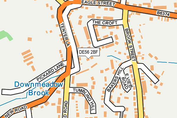
DE56 2BF lies on Bank Side in Heage, Belper. DE56 2BF is located in the Heage & Ambergate electoral ward, within the local authority district of Amber Valley and the English Parliamentary constituency of Amber Valley. The Sub Integrated Care Board (ICB) Location is NHS Derby and Derbyshire ICB - 15M and the police force is Derbyshire. This postcode has been in use since May 2005.


GetTheData
Source: OS OpenMap – Local (Ordnance Survey)
Source: OS VectorMap District (Ordnance Survey)
Licence: Open Government Licence (requires attribution)
| Easting | 437057 |
| Northing | 350346 |
| Latitude | 53.049098 |
| Longitude | -1.448658 |
GetTheData
Source: Open Postcode Geo
Licence: Open Government Licence
| Street | Bank Side |
| Locality | Heage |
| Town/City | Belper |
| Country | England |
| Postcode District | DE56 |
| ➜ DE56 open data dashboard ➜ See where DE56 is on a map ➜ Where is Heage? | |
GetTheData
Source: Land Registry Price Paid Data
Licence: Open Government Licence
Elevation or altitude of DE56 2BF as distance above sea level:
| Metres | Feet | |
|---|---|---|
| Elevation | 110m | 361ft |
Elevation is measured from the approximate centre of the postcode, to the nearest point on an OS contour line from OS Terrain 50, which has contour spacing of ten vertical metres.
➜ How high above sea level am I? Find the elevation of your current position using your device's GPS.
GetTheData
Source: Open Postcode Elevation
Licence: Open Government Licence
| Ward | Heage & Ambergate |
| Constituency | Amber Valley |
GetTheData
Source: ONS Postcode Database
Licence: Open Government Licence
| June 2023 | Other theft | On or near Bowling Alley | 51m |
| December 2022 | Anti-social behaviour | On or near Bowling Alley | 51m |
| August 2022 | Anti-social behaviour | On or near Bowling Alley | 51m |
| ➜ Get more crime data in our Crime section | |||
GetTheData
Source: data.police.uk
Licence: Open Government Licence
| Black Boy (Old Road) | Heage | 110m |
| Black Boy (Old Road) | Heage | 133m |
| Bakers Hill (Brook Street) | Heage | 143m |
| Bakers Hill (Brook Street) | Heage | 151m |
| Eagle Tavern (Brook Street) | Heage | 188m |
| Ambergate Station | 2.5km |
| Belper Station | 3.6km |
| Whatstandwell Station | 5.3km |
GetTheData
Source: NaPTAN
Licence: Open Government Licence
| Percentage of properties with Next Generation Access | 100.0% |
| Percentage of properties with Superfast Broadband | 100.0% |
| Percentage of properties with Ultrafast Broadband | 0.0% |
| Percentage of properties with Full Fibre Broadband | 0.0% |
Superfast Broadband is between 30Mbps and 300Mbps
Ultrafast Broadband is > 300Mbps
| Percentage of properties unable to receive 2Mbps | 0.0% |
| Percentage of properties unable to receive 5Mbps | 0.0% |
| Percentage of properties unable to receive 10Mbps | 0.0% |
| Percentage of properties unable to receive 30Mbps | 0.0% |
GetTheData
Source: Ofcom
Licence: Ofcom Terms of Use (requires attribution)
GetTheData
Source: ONS Postcode Database
Licence: Open Government Licence


➜ Get more ratings from the Food Standards Agency
GetTheData
Source: Food Standards Agency
Licence: FSA terms & conditions
| Last Collection | |||
|---|---|---|---|
| Location | Mon-Fri | Sat | Distance |
| High Green | 17:00 | 08:00 | 219m |
| Green Man | 16:00 | 10:15 | 761m |
| Old Heage Post Office | 17:00 | 07:45 | 870m |
GetTheData
Source: Dracos
Licence: Creative Commons Attribution-ShareAlike
| Facility | Distance |
|---|---|
| Thomas William Heage Recreation Ground Old Road, Heage, Belper Grass Pitches | 347m |
| Heage Primary School School Lane, Heage, Belper Grass Pitches, Sports Hall | 401m |
| Alton Manor Recreation Ground Nailers Way, Belper Grass Pitches | 1.9km |
GetTheData
Source: Active Places
Licence: Open Government Licence
| School | Phase of Education | Distance |
|---|---|---|
| Heage Primary School School Lane, Heage, Belper, DE56 2AL | Primary | 399m |
| Ambergate Primary School Toadmoor Lane, Ambergate, Belper, DE56 2GN | Primary | 2.3km |
| Ripley Nursery School Sandham Lane, Ripley, DE5 3HE | Nursery | 2.4km |
GetTheData
Source: Edubase
Licence: Open Government Licence
The below table lists the International Territorial Level (ITL) codes (formerly Nomenclature of Territorial Units for Statistics (NUTS) codes) and Local Administrative Units (LAU) codes for DE56 2BF:
| ITL 1 Code | Name |
|---|---|
| TLF | East Midlands (England) |
| ITL 2 Code | Name |
| TLF1 | Derbyshire and Nottinghamshire |
| ITL 3 Code | Name |
| TLF13 | South and West Derbyshire |
| LAU 1 Code | Name |
| E07000032 | Amber Valley |
GetTheData
Source: ONS Postcode Directory
Licence: Open Government Licence
The below table lists the Census Output Area (OA), Lower Layer Super Output Area (LSOA), and Middle Layer Super Output Area (MSOA) for DE56 2BF:
| Code | Name | |
|---|---|---|
| OA | E00098262 | |
| LSOA | E01019429 | Amber Valley 006A |
| MSOA | E02004034 | Amber Valley 006 |
GetTheData
Source: ONS Postcode Directory
Licence: Open Government Licence
| DE56 2BJ | Bowling Alley | 43m |
| DE56 2BQ | The Croft | 86m |
| DE56 2BE | Tenter Lane | 106m |
| DE56 2BL | Bakers Hill | 136m |
| DE56 2BX | Tumbling Hill | 142m |
| DE56 2BT | East View Road | 142m |
| DE56 2AJ | Eagle Street | 183m |
| DE56 2AG | Brook Street | 217m |
| DE56 2BD | Pickard Lane | 263m |
| DE56 2BB | Schoolhouse Hill | 283m |
GetTheData
Source: Open Postcode Geo; Land Registry Price Paid Data
Licence: Open Government Licence