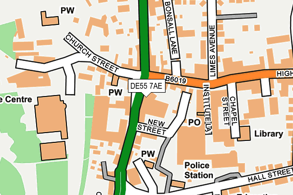
DE55 7AE is located in the Alfreton electoral ward, within the local authority district of Amber Valley and the English Parliamentary constituency of Amber Valley. The Sub Integrated Care Board (ICB) Location is NHS Derby and Derbyshire ICB - 15M and the police force is Derbyshire. This postcode has been in use since August 1992.


GetTheData
Source: OS OpenMap – Local (Ordnance Survey)
Source: OS VectorMap District (Ordnance Survey)
Licence: Open Government Licence (requires attribution)
| Easting | 440931 |
| Northing | 355728 |
| Latitude | 53.097193 |
| Longitude | -1.390188 |
GetTheData
Source: Open Postcode Geo
Licence: Open Government Licence
| Country | England |
| Postcode District | DE55 |
| ➜ DE55 open data dashboard ➜ See where DE55 is on a map ➜ Where is Alfreton? | |
GetTheData
Source: Land Registry Price Paid Data
Licence: Open Government Licence
Elevation or altitude of DE55 7AE as distance above sea level:
| Metres | Feet | |
|---|---|---|
| Elevation | 130m | 427ft |
Elevation is measured from the approximate centre of the postcode, to the nearest point on an OS contour line from OS Terrain 50, which has contour spacing of ten vertical metres.
➜ How high above sea level am I? Find the elevation of your current position using your device's GPS.
GetTheData
Source: Open Postcode Elevation
Licence: Open Government Licence
| Ward | Alfreton |
| Constituency | Amber Valley |
GetTheData
Source: ONS Postcode Database
Licence: Open Government Licence
| January 2024 | Violence and sexual offences | On or near Parking Area | 256m |
| December 2023 | Public order | On or near Parking Area | 256m |
| December 2023 | Anti-social behaviour | On or near Parking Area | 256m |
| ➜ Get more crime data in our Crime section | |||
GetTheData
Source: data.police.uk
Licence: Open Government Licence
| King Street | Alfreton | 35m |
| High Street | Alfreton | 107m |
| High Street | Alfreton | 145m |
| High Street | Alfreton | 170m |
| Limes Avenue | Alfreton | 186m |
| Alfreton Station | 1.4km |
GetTheData
Source: NaPTAN
Licence: Open Government Licence
GetTheData
Source: ONS Postcode Database
Licence: Open Government Licence


➜ Get more ratings from the Food Standards Agency
GetTheData
Source: Food Standards Agency
Licence: FSA terms & conditions
| Last Collection | |||
|---|---|---|---|
| Location | Mon-Fri | Sat | Distance |
| Alfreton Main Post Office | 18:30 | 12:00 | 117m |
| Arthur Street | 17:30 | 09:30 | 418m |
| Grange Street | 17:30 | 09:30 | 446m |
GetTheData
Source: Dracos
Licence: Creative Commons Attribution-ShareAlike
| Facility | Distance |
|---|---|
| Genesis Family Entertainment Centre King Street, Alfreton Sports Hall, Studio | 98m |
| In Trim Health Club (Closed) King Street, Alfreton Health and Fitness Gym | 107m |
| Alfreton Leisure Centre Alfreton Park, Alfreton Sports Hall, Indoor Bowls, Health and Fitness Gym, Swimming Pool, Squash Courts, Studio | 211m |
GetTheData
Source: Active Places
Licence: Open Government Licence
| School | Phase of Education | Distance |
|---|---|---|
| Croft Infant School Marshall Street, Alfreton, DE55 7BW | Primary | 310m |
| Alfreton Nursery School Stanton Close, Alfreton, DE55 7SH | Nursery | 419m |
| Woodbridge Junior School Grange Street, Alfreton, DE55 7JA | Primary | 472m |
GetTheData
Source: Edubase
Licence: Open Government Licence
The below table lists the International Territorial Level (ITL) codes (formerly Nomenclature of Territorial Units for Statistics (NUTS) codes) and Local Administrative Units (LAU) codes for DE55 7AE:
| ITL 1 Code | Name |
|---|---|
| TLF | East Midlands (England) |
| ITL 2 Code | Name |
| TLF1 | Derbyshire and Nottinghamshire |
| ITL 3 Code | Name |
| TLF13 | South and West Derbyshire |
| LAU 1 Code | Name |
| E07000032 | Amber Valley |
GetTheData
Source: ONS Postcode Directory
Licence: Open Government Licence
The below table lists the Census Output Area (OA), Lower Layer Super Output Area (LSOA), and Middle Layer Super Output Area (MSOA) for DE55 7AE:
| Code | Name | |
|---|---|---|
| OA | E00098124 | |
| LSOA | E01019401 | Amber Valley 001B |
| MSOA | E02004029 | Amber Valley 001 |
GetTheData
Source: ONS Postcode Directory
Licence: Open Government Licence
| DE55 7AG | King Street | 38m |
| DE55 7BP | New Street | 70m |
| DE55 7DR | High Street | 88m |
| DE55 7DS | Bonsall Lane | 122m |
| DE55 7AH | Church Street | 134m |
| DE55 7BY | King Street | 140m |
| DE55 7BQ | Institute Lane | 147m |
| DE55 7DD | King Street | 162m |
| DE55 7DT | Chesterfield Road | 188m |
| DE55 7DW | Limes Avenue | 211m |
GetTheData
Source: Open Postcode Geo; Land Registry Price Paid Data
Licence: Open Government Licence