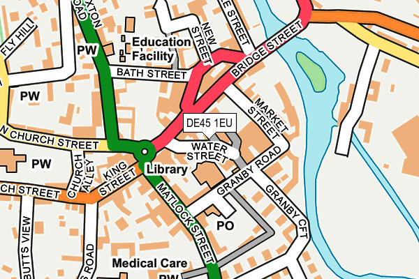
DE45 1EU lies on Water Lane in Bakewell. DE45 1EU is located in the Bakewell electoral ward, within the local authority district of Derbyshire Dales and the English Parliamentary constituency of Derbyshire Dales. The Sub Integrated Care Board (ICB) Location is NHS Derby and Derbyshire ICB - 15M and the police force is Derbyshire. This postcode has been in use since August 1992.


GetTheData
Source: OS OpenMap – Local (Ordnance Survey)
Source: OS VectorMap District (Ordnance Survey)
Licence: Open Government Licence (requires attribution)
| Easting | 421860 |
| Northing | 368517 |
| Latitude | 53.213286 |
| Longitude | -1.674118 |
GetTheData
Source: Open Postcode Geo
Licence: Open Government Licence
| Street | Water Lane |
| Town/City | Bakewell |
| Country | England |
| Postcode District | DE45 |
➜ See where DE45 is on a map ➜ Where is Bakewell? | |
GetTheData
Source: Land Registry Price Paid Data
Licence: Open Government Licence
Elevation or altitude of DE45 1EU as distance above sea level:
| Metres | Feet | |
|---|---|---|
| Elevation | 120m | 394ft |
Elevation is measured from the approximate centre of the postcode, to the nearest point on an OS contour line from OS Terrain 50, which has contour spacing of ten vertical metres.
➜ How high above sea level am I? Find the elevation of your current position using your device's GPS.
GetTheData
Source: Open Postcode Elevation
Licence: Open Government Licence
| Ward | Bakewell |
| Constituency | Derbyshire Dales |
GetTheData
Source: ONS Postcode Database
Licence: Open Government Licence
| Square (Bridge Street) | Bakewell | 39m |
| Square (Rutland Square) | Bakewell | 69m |
| Square (Rutland Square) | Bakewell | 75m |
| Square (Rutland Square) | Bakewell | 85m |
| Matlock Street | Bakewell | 155m |
GetTheData
Source: NaPTAN
Licence: Open Government Licence
GetTheData
Source: ONS Postcode Database
Licence: Open Government Licence


➜ Get more ratings from the Food Standards Agency
GetTheData
Source: Food Standards Agency
Licence: FSA terms & conditions
| Last Collection | |||
|---|---|---|---|
| Location | Mon-Fri | Sat | Distance |
| Rutland Square | 17:30 | 11:30 | 43m |
| Bakewell Post Office | 18:30 | 11:30 | 98m |
| Oddfellows Terrace | 17:30 | 08:15 | 312m |
GetTheData
Source: Dracos
Licence: Creative Commons Attribution-ShareAlike
| Risk of DE45 1EU flooding from rivers and sea | Medium |
| ➜ DE45 1EU flood map | |
GetTheData
Source: Open Flood Risk by Postcode
Licence: Open Government Licence
The below table lists the International Territorial Level (ITL) codes (formerly Nomenclature of Territorial Units for Statistics (NUTS) codes) and Local Administrative Units (LAU) codes for DE45 1EU:
| ITL 1 Code | Name |
|---|---|
| TLF | East Midlands (England) |
| ITL 2 Code | Name |
| TLF1 | Derbyshire and Nottinghamshire |
| ITL 3 Code | Name |
| TLF13 | South and West Derbyshire |
| LAU 1 Code | Name |
| E07000035 | Derbyshire Dales |
GetTheData
Source: ONS Postcode Directory
Licence: Open Government Licence
The below table lists the Census Output Area (OA), Lower Layer Super Output Area (LSOA), and Middle Layer Super Output Area (MSOA) for DE45 1EU:
| Code | Name | |
|---|---|---|
| OA | E00099139 | |
| LSOA | E01019600 | Derbyshire Dales 002A |
| MSOA | E02004069 | Derbyshire Dales 002 |
GetTheData
Source: ONS Postcode Directory
Licence: Open Government Licence
| DE45 1EW | Water Street | 35m |
| DE45 1DS | Bridge Street | 54m |
| DE45 1ES | Granby Road | 70m |
| DE45 1BT | The Square | 79m |
| DE45 1HF | Riverside Crescent | 106m |
| DE45 1HD | Matlock Street | 107m |
| DE45 1GQ | Matlock Street | 125m |
| DE45 1DW | New Street | 132m |
| DE45 1EE | Matlock Street | 140m |
| DE45 1BX | Bath Street | 144m |
GetTheData
Source: Open Postcode Geo; Land Registry Price Paid Data
Licence: Open Government Licence