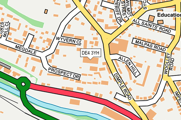
DE4 3YH is located in the Matlock West electoral ward, within the local authority district of Derbyshire Dales and the English Parliamentary constituency of Derbyshire Dales. The Sub Integrated Care Board (ICB) Location is NHS Derby and Derbyshire ICB - 15M and the police force is Derbyshire. This postcode has been in use since December 2001.


GetTheData
Source: OS OpenMap – Local (Ordnance Survey)
Source: OS VectorMap District (Ordnance Survey)
Licence: Open Government Licence (requires attribution)
| Easting | 429441 |
| Northing | 360607 |
| Latitude | 53.141804 |
| Longitude | -1.561328 |
GetTheData
Source: Open Postcode Geo
Licence: Open Government Licence
| Country | England |
| Postcode District | DE4 |
| ➜ DE4 open data dashboard ➜ See where DE4 is on a map ➜ Where is Matlock? | |
GetTheData
Source: Land Registry Price Paid Data
Licence: Open Government Licence
Elevation or altitude of DE4 3YH as distance above sea level:
| Metres | Feet | |
|---|---|---|
| Elevation | 120m | 394ft |
Elevation is measured from the approximate centre of the postcode, to the nearest point on an OS contour line from OS Terrain 50, which has contour spacing of ten vertical metres.
➜ How high above sea level am I? Find the elevation of your current position using your device's GPS.
GetTheData
Source: Open Postcode Elevation
Licence: Open Government Licence
| Ward | Matlock West |
| Constituency | Derbyshire Dales |
GetTheData
Source: ONS Postcode Database
Licence: Open Government Licence
| March 2023 | Violence and sexual offences | On or near All Saints' Road | 238m |
| March 2023 | Burglary | On or near All Saints' Road | 238m |
| March 2023 | Violence and sexual offences | On or near All Saints' Road | 238m |
| ➜ Get more crime data in our Crime section | |||
GetTheData
Source: data.police.uk
Licence: Open Government Licence
| Dimple Mill (Dimple Road) | Matlock | 98m |
| Twiggs (Bakewell Road) | Matlock | 120m |
| Dimple Mill (Dimple Road) | Matlock | 127m |
| Twiggs (Bakewell Road) | Matlock | 133m |
| Sainsburys (Cawdor Way) | Matlock | 344m |
| Matlock (Peak Rail) | Matlock | 460m |
| Matlock Station | 0.4km |
| Matlock Bath Station | 2.2km |
| Cromford Station | 3.3km |
GetTheData
Source: NaPTAN
Licence: Open Government Licence
GetTheData
Source: ONS Postcode Database
Licence: Open Government Licence


➜ Get more ratings from the Food Standards Agency
GetTheData
Source: Food Standards Agency
Licence: FSA terms & conditions
| Last Collection | |||
|---|---|---|---|
| Location | Mon-Fri | Sat | Distance |
| Dimple | 17:30 | 08:00 | 109m |
| Holme Close | 17:00 | 07:30 | 250m |
| Far Green | 17:30 | 08:00 | 395m |
GetTheData
Source: Dracos
Licence: Creative Commons Attribution-ShareAlike
| Facility | Distance |
|---|---|
| Dimple Recreation Ground Hurds Hollow, Matlock Grass Pitches | 221m |
| Matlock Swimming Pool (Closed) Imperial Road, Matlock Swimming Pool, Health and Fitness Gym | 495m |
| Arc Leisure Matlock Bakewell Road, Matlock Swimming Pool, Health and Fitness Gym, Sports Hall, Studio | 580m |
GetTheData
Source: Active Places
Licence: Open Government Licence
| School | Phase of Education | Distance |
|---|---|---|
| All Saints CofE Infant School Dimple Road, Matlock, DE4 3HX | Primary | 244m |
| All Saints CofE Junior School Hurds Hollow, Matlock, DE4 3LA | Primary | 515m |
| Castle View Primary School School Road, Matlock, DE4 3DS | Primary | 1.1km |
GetTheData
Source: Edubase
Licence: Open Government Licence
The below table lists the International Territorial Level (ITL) codes (formerly Nomenclature of Territorial Units for Statistics (NUTS) codes) and Local Administrative Units (LAU) codes for DE4 3YH:
| ITL 1 Code | Name |
|---|---|
| TLF | East Midlands (England) |
| ITL 2 Code | Name |
| TLF1 | Derbyshire and Nottinghamshire |
| ITL 3 Code | Name |
| TLF13 | South and West Derbyshire |
| LAU 1 Code | Name |
| E07000035 | Derbyshire Dales |
GetTheData
Source: ONS Postcode Directory
Licence: Open Government Licence
The below table lists the Census Output Area (OA), Lower Layer Super Output Area (LSOA), and Middle Layer Super Output Area (MSOA) for DE4 3YH:
| Code | Name | |
|---|---|---|
| OA | E00099279 | |
| LSOA | E01019624 | Derbyshire Dales 005D |
| MSOA | E02004072 | Derbyshire Dales 005 |
GetTheData
Source: ONS Postcode Directory
Licence: Open Government Licence
| DE4 3JU | Wyvern Close | 72m |
| DE4 3JX | Dimple Road | 82m |
| DE4 3TA | Prospect Drive | 106m |
| DE4 3LR | Allen Hill | 137m |
| DE4 3PJ | Dimple Crescent | 165m |
| DE4 3EZ | The Beeches | 191m |
| DE4 3HT | Malpas Road | 201m |
| DE4 3JT | Sheriff Drive | 206m |
| DE4 3JZ | Hurds Hollow | 209m |
| DE4 3LS | Dalesfield | 214m |
GetTheData
Source: Open Postcode Geo; Land Registry Price Paid Data
Licence: Open Government Licence