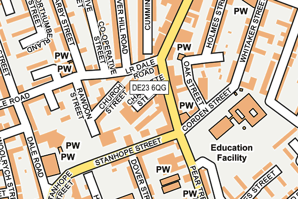
DE23 6QG is located in the Normanton electoral ward, within the unitary authority of Derby and the English Parliamentary constituency of Derby South. The Sub Integrated Care Board (ICB) Location is NHS Derby and Derbyshire ICB - 15M and the police force is Derbyshire. This postcode has been in use since August 1992.


GetTheData
Source: OS OpenMap – Local (Ordnance Survey)
Source: OS VectorMap District (Ordnance Survey)
Licence: Open Government Licence (requires attribution)
| Easting | 435119 |
| Northing | 334653 |
| Latitude | 52.908185 |
| Longitude | -1.479260 |
GetTheData
Source: Open Postcode Geo
Licence: Open Government Licence
| Country | England |
| Postcode District | DE23 |
| ➜ DE23 open data dashboard ➜ See where DE23 is on a map ➜ Where is Derby? | |
GetTheData
Source: Land Registry Price Paid Data
Licence: Open Government Licence
Elevation or altitude of DE23 6QG as distance above sea level:
| Metres | Feet | |
|---|---|---|
| Elevation | 60m | 197ft |
Elevation is measured from the approximate centre of the postcode, to the nearest point on an OS contour line from OS Terrain 50, which has contour spacing of ten vertical metres.
➜ How high above sea level am I? Find the elevation of your current position using your device's GPS.
GetTheData
Source: Open Postcode Elevation
Licence: Open Government Licence
| Ward | Normanton |
| Constituency | Derby South |
GetTheData
Source: ONS Postcode Database
Licence: Open Government Licence
| January 2024 | Vehicle crime | On or near Church Street | 92m |
| January 2024 | Violence and sexual offences | On or near Church Street | 92m |
| January 2024 | Anti-social behaviour | On or near Parking Area | 183m |
| ➜ Get more crime data in our Crime section | |||
GetTheData
Source: data.police.uk
Licence: Open Government Licence
| Stanhope Street | Normanton | 77m |
| Stanhope Street | Normanton | 80m |
| Lower Dale Road (Normanton Road) | Rose Hill | 134m |
| Yates Street (Pear Tree Road) | Normanton | 161m |
| Lower Dale Road (Normanton Road) | Rose Hill | 167m |
| Peartree Station | 1.3km |
| Derby Station | 1.4km |
| Spondon Station | 4.6km |
GetTheData
Source: NaPTAN
Licence: Open Government Licence
GetTheData
Source: ONS Postcode Database
Licence: Open Government Licence


➜ Get more ratings from the Food Standards Agency
GetTheData
Source: Food Standards Agency
Licence: FSA terms & conditions
| Last Collection | |||
|---|---|---|---|
| Location | Mon-Fri | Sat | Distance |
| Lower Dale Road | 17:30 | 10:30 | 229m |
| Normanton Road Post Office | 17:30 | 12:00 | 255m |
| Peartree Road, Derby | 17:30 | 12:00 | 311m |
GetTheData
Source: Dracos
Licence: Creative Commons Attribution-ShareAlike
| Facility | Distance |
|---|---|
| Hardwick Primary School Dover Street, Derby Sports Hall, Studio | 210m |
| Arboretum Park Rosehill Street, Derby Grass Pitches, Artificial Grass Pitch | 604m |
| St Joseph's Catholic Primary School Mill Hill Lane, Derby Grass Pitches | 618m |
GetTheData
Source: Active Places
Licence: Open Government Licence
| School | Phase of Education | Distance |
|---|---|---|
| Hardwick Primary School Dover Street, Derby, DE23 6QP | Primary | 190m |
| Arboretum Primary School Corden Street, Derby, DE23 8GP | Primary | 195m |
| Derby St Chad's CofE Nursery and Infant School Gordon Road, Gordon Road Normanton, Derby, DE23 6WR | Primary | 400m |
GetTheData
Source: Edubase
Licence: Open Government Licence
The below table lists the International Territorial Level (ITL) codes (formerly Nomenclature of Territorial Units for Statistics (NUTS) codes) and Local Administrative Units (LAU) codes for DE23 6QG:
| ITL 1 Code | Name |
|---|---|
| TLF | East Midlands (England) |
| ITL 2 Code | Name |
| TLF1 | Derbyshire and Nottinghamshire |
| ITL 3 Code | Name |
| TLF11 | Derby |
| LAU 1 Code | Name |
| E06000015 | Derby |
GetTheData
Source: ONS Postcode Directory
Licence: Open Government Licence
The below table lists the Census Output Area (OA), Lower Layer Super Output Area (LSOA), and Middle Layer Super Output Area (MSOA) for DE23 6QG:
| Code | Name | |
|---|---|---|
| OA | E00068518 | |
| LSOA | E01013566 | Derby 016E |
| MSOA | E02002811 | Derby 016 |
GetTheData
Source: ONS Postcode Directory
Licence: Open Government Licence
| DE23 6PY | Pear Tree Road | 25m |
| DE23 6PZ | Pear Tree Road | 53m |
| DE23 6QT | Church Street | 78m |
| DE23 6WY | Lower Dale Road | 98m |
| DE23 6QS | Rawdon Street | 119m |
| DE23 8GL | Whiston Street | 123m |
| DE23 6QR | Rawdon Street | 150m |
| DE23 6QP | Dover Street | 158m |
| DE23 6UJ | Silver Hill Road | 171m |
| DE23 6QA | Pear Tree Road | 172m |
GetTheData
Source: Open Postcode Geo; Land Registry Price Paid Data
Licence: Open Government Licence