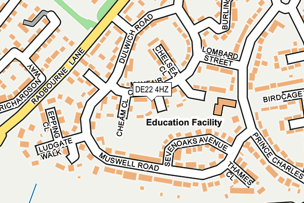
DE22 4HZ lies on Highbury Close in Derby. DE22 4HZ is located in the Mackworth & New Zealand electoral ward, within the unitary authority of Derby and the English Parliamentary constituency of Derby North. The Sub Integrated Care Board (ICB) Location is NHS Derby and Derbyshire ICB - 15M and the police force is Derbyshire. This postcode has been in use since August 1992.


GetTheData
Source: OS OpenMap – Local (Ordnance Survey)
Source: OS VectorMap District (Ordnance Survey)
Licence: Open Government Licence (requires attribution)
| Easting | 431531 |
| Northing | 336592 |
| Latitude | 52.925836 |
| Longitude | -1.532419 |
GetTheData
Source: Open Postcode Geo
Licence: Open Government Licence
| Street | Highbury Close |
| Town/City | Derby |
| Country | England |
| Postcode District | DE22 |
| ➜ DE22 open data dashboard ➜ See where DE22 is on a map ➜ Where is Derby? | |
GetTheData
Source: Land Registry Price Paid Data
Licence: Open Government Licence
Elevation or altitude of DE22 4HZ as distance above sea level:
| Metres | Feet | |
|---|---|---|
| Elevation | 100m | 328ft |
Elevation is measured from the approximate centre of the postcode, to the nearest point on an OS contour line from OS Terrain 50, which has contour spacing of ten vertical metres.
➜ How high above sea level am I? Find the elevation of your current position using your device's GPS.
GetTheData
Source: Open Postcode Elevation
Licence: Open Government Licence
| Ward | Mackworth & New Zealand |
| Constituency | Derby North |
GetTheData
Source: ONS Postcode Database
Licence: Open Government Licence
| January 2024 | Other theft | On or near Brompton Road | 274m |
| December 2023 | Violence and sexual offences | On or near Brompton Road | 274m |
| September 2023 | Public order | On or near Brompton Road | 274m |
| ➜ Highbury Close crime map and outcomes | |||
GetTheData
Source: data.police.uk
Licence: Open Government Licence
| Muswell Road (Prince Charles Avenue) | Mackworth Estate | 146m |
| Muswell Road (Prince Charles Avenue) | Mackworth Estate | 159m |
| Moorgate (Radbourne Lane) | Mackworth Estate | 187m |
| Lombard Street (Prince Charles Avenue) | Mackworth Estate | 189m |
| Moorgate (Radbourne Lane) | Mackworth Estate | 199m |
| Derby Station | 4.8km |
| Peartree Station | 5.1km |
GetTheData
Source: NaPTAN
Licence: Open Government Licence
| Percentage of properties with Next Generation Access | 100.0% |
| Percentage of properties with Superfast Broadband | 100.0% |
| Percentage of properties with Ultrafast Broadband | 100.0% |
| Percentage of properties with Full Fibre Broadband | 0.0% |
Superfast Broadband is between 30Mbps and 300Mbps
Ultrafast Broadband is > 300Mbps
| Percentage of properties unable to receive 2Mbps | 0.0% |
| Percentage of properties unable to receive 5Mbps | 0.0% |
| Percentage of properties unable to receive 10Mbps | 0.0% |
| Percentage of properties unable to receive 30Mbps | 0.0% |
GetTheData
Source: Ofcom
Licence: Ofcom Terms of Use (requires attribution)
GetTheData
Source: ONS Postcode Database
Licence: Open Government Licence


➜ Get more ratings from the Food Standards Agency
GetTheData
Source: Food Standards Agency
Licence: FSA terms & conditions
| Last Collection | |||
|---|---|---|---|
| Location | Mon-Fri | Sat | Distance |
| Henley Green | 17:30 | 11:00 | 316m |
| Aldersgate | 17:30 | 11:00 | 765m |
| Station Road | 17:30 | 11:00 | 862m |
GetTheData
Source: Dracos
Licence: Creative Commons Attribution-ShareAlike
| Facility | Distance |
|---|---|
| Derby Grammar School (Rykneld Sports Centre) Richmond Park Road, Derby Sports Hall, Health and Fitness Gym, Artificial Grass Pitch, Grass Pitches | 292m |
| Mickleover Sports Club Station Road, Mickleover, Derby Grass Pitches, Artificial Grass Pitch | 605m |
| Station Road Playing Field (Mickleover) Station Road, Station Road, Mickleover, Derby Grass Pitches | 620m |
GetTheData
Source: Active Places
Licence: Open Government Licence
| School | Phase of Education | Distance |
|---|---|---|
| Maple View School 305a Prince Charles Avenue, Mackworth, Derby, DE22 4LL | Not applicable | 106m |
| Reigate Park Primary Academy Reigate Drive, Mackworth Estate, Derby, DE22 4EQ | Primary | 638m |
| Murray Park Community School Murray Road, Mickleover, Derby, DE3 9LL | Secondary | 864m |
GetTheData
Source: Edubase
Licence: Open Government Licence
The below table lists the International Territorial Level (ITL) codes (formerly Nomenclature of Territorial Units for Statistics (NUTS) codes) and Local Administrative Units (LAU) codes for DE22 4HZ:
| ITL 1 Code | Name |
|---|---|
| TLF | East Midlands (England) |
| ITL 2 Code | Name |
| TLF1 | Derbyshire and Nottinghamshire |
| ITL 3 Code | Name |
| TLF11 | Derby |
| LAU 1 Code | Name |
| E06000015 | Derby |
GetTheData
Source: ONS Postcode Directory
Licence: Open Government Licence
The below table lists the Census Output Area (OA), Lower Layer Super Output Area (LSOA), and Middle Layer Super Output Area (MSOA) for DE22 4HZ:
| Code | Name | |
|---|---|---|
| OA | E00068406 | |
| LSOA | E01013549 | Derby 009B |
| MSOA | E02002804 | Derby 009 |
GetTheData
Source: ONS Postcode Directory
Licence: Open Government Licence
| DE22 4LD | Birdcage Walk | 24m |
| DE22 4JA | Farringdon Close | 34m |
| DE22 4HW | Mayfair Crescent | 54m |
| DE22 4HU | Sevenoaks Avenue | 82m |
| DE22 4JB | Chelsea Close | 98m |
| DE22 4HX | Mayfair Crescent | 124m |
| DE22 4JD | Lombard Street | 126m |
| DE22 4HN | Muswell Road | 130m |
| DE22 4HL | Muswell Road | 131m |
| DE22 4HG | Dulwich Road | 136m |
GetTheData
Source: Open Postcode Geo; Land Registry Price Paid Data
Licence: Open Government Licence