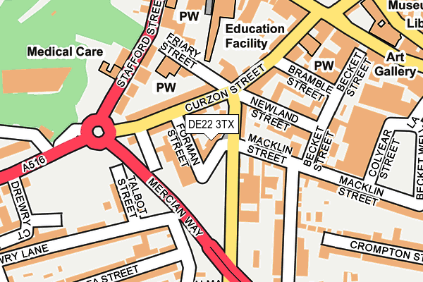
DE22 3TX lies on Monk Street North in Derby. DE22 3TX is located in the Arboretum electoral ward, within the unitary authority of Derby and the English Parliamentary constituency of Derby North. The Sub Integrated Care Board (ICB) Location is NHS Derby and Derbyshire ICB - 15M and the police force is Derbyshire. This postcode has been in use since February 2010.


GetTheData
Source: OS OpenMap – Local (Ordnance Survey)
Source: OS VectorMap District (Ordnance Survey)
Licence: Open Government Licence (requires attribution)
| Easting | 434826 |
| Northing | 336108 |
| Latitude | 52.921265 |
| Longitude | -1.483465 |
GetTheData
Source: Open Postcode Geo
Licence: Open Government Licence
| Street | Monk Street North |
| Town/City | Derby |
| Country | England |
| Postcode District | DE22 |
| ➜ DE22 open data dashboard ➜ See where DE22 is on a map ➜ Where is Derby? | |
GetTheData
Source: Land Registry Price Paid Data
Licence: Open Government Licence
Elevation or altitude of DE22 3TX as distance above sea level:
| Metres | Feet | |
|---|---|---|
| Elevation | 50m | 164ft |
Elevation is measured from the approximate centre of the postcode, to the nearest point on an OS contour line from OS Terrain 50, which has contour spacing of ten vertical metres.
➜ How high above sea level am I? Find the elevation of your current position using your device's GPS.
GetTheData
Source: Open Postcode Elevation
Licence: Open Government Licence
| Ward | Arboretum |
| Constituency | Derby North |
GetTheData
Source: ONS Postcode Database
Licence: Open Government Licence
| December 2023 | Other theft | On or near Parking Area | 287m |
| October 2023 | Violence and sexual offences | On or near Parking Area | 287m |
| September 2023 | Anti-social behaviour | On or near Parking Area | 287m |
| ➜ Get more crime data in our Crime section | |||
GetTheData
Source: data.police.uk
Licence: Open Government Licence
| Macklin Street (Abbey Street) | Derby | 53m |
| Macklin Street (Abbey Street) | Derby | 71m |
| Curzon Street | Derby | 114m |
| Friar Gate | Derby | 237m |
| Friar Gate | Derby | 238m |
| Derby Station | 1.5km |
| Peartree Station | 2.8km |
| Spondon Station | 5km |
GetTheData
Source: NaPTAN
Licence: Open Government Licence
| Percentage of properties with Next Generation Access | 100.0% |
| Percentage of properties with Superfast Broadband | 100.0% |
| Percentage of properties with Ultrafast Broadband | 100.0% |
| Percentage of properties with Full Fibre Broadband | 20.0% |
Superfast Broadband is between 30Mbps and 300Mbps
Ultrafast Broadband is > 300Mbps
| Percentage of properties unable to receive 2Mbps | 0.0% |
| Percentage of properties unable to receive 5Mbps | 0.0% |
| Percentage of properties unable to receive 10Mbps | 0.0% |
| Percentage of properties unable to receive 30Mbps | 0.0% |
GetTheData
Source: Ofcom
Licence: Ofcom Terms of Use (requires attribution)
GetTheData
Source: ONS Postcode Database
Licence: Open Government Licence


➜ Get more ratings from the Food Standards Agency
GetTheData
Source: Food Standards Agency
Licence: FSA terms & conditions
| Last Collection | |||
|---|---|---|---|
| Location | Mon-Fri | Sat | Distance |
| Wolfa Street | 17:30 | 12:00 | 172m |
| The Friary | 18:30 | 12:00 | 248m |
| Uttoxeter New Road | 17:30 | 11:30 | 361m |
GetTheData
Source: Dracos
Licence: Creative Commons Attribution-ShareAlike
| Facility | Distance |
|---|---|
| Becket Primary School Monk Street, Derby Grass Pitches | 381m |
| Willows Sports Centre Derby Willow Row, Derby Artificial Grass Pitch | 420m |
| Reviva Health Club For Women (Derby) (Closed) St. James Chambers, St. James Street, Derby Studio, Health and Fitness Gym | 426m |
GetTheData
Source: Active Places
Licence: Open Government Licence
| School | Phase of Education | Distance |
|---|---|---|
| Becket Primary School Monk Street, Derby, DE22 3QB | Primary | 381m |
| Derby Cathedral School Great Northern Road, Derby, DE1 1LR | Secondary | 603m |
| Castle School 56 Cedar Street, Derby, DE22 1GE | Not applicable | 643m |
GetTheData
Source: Edubase
Licence: Open Government Licence
The below table lists the International Territorial Level (ITL) codes (formerly Nomenclature of Territorial Units for Statistics (NUTS) codes) and Local Administrative Units (LAU) codes for DE22 3TX:
| ITL 1 Code | Name |
|---|---|
| TLF | East Midlands (England) |
| ITL 2 Code | Name |
| TLF1 | Derbyshire and Nottinghamshire |
| ITL 3 Code | Name |
| TLF11 | Derby |
| LAU 1 Code | Name |
| E06000015 | Derby |
GetTheData
Source: ONS Postcode Directory
Licence: Open Government Licence
The below table lists the Census Output Area (OA), Lower Layer Super Output Area (LSOA), and Middle Layer Super Output Area (MSOA) for DE22 3TX:
| Code | Name | |
|---|---|---|
| OA | E00067918 | |
| LSOA | E01013460 | Derby 013E |
| MSOA | E02002808 | Derby 013 |
GetTheData
Source: ONS Postcode Directory
Licence: Open Government Licence
| DE1 1JQ | Forman Street | 26m |
| DE22 3SJ | Abbey Street | 41m |
| DE1 1LN | Curzon Street | 48m |
| DE1 1JD | Newland Street | 75m |
| DE1 1LP | Curzon Street | 82m |
| DE1 1JF | Friary Street | 106m |
| DE1 1LG | Macklin Street | 112m |
| DE1 1JL | Stafford Street | 135m |
| DE1 1NZ | Gerard Street | 136m |
| DE1 1LH | Curzon Street | 137m |
GetTheData
Source: Open Postcode Geo; Land Registry Price Paid Data
Licence: Open Government Licence