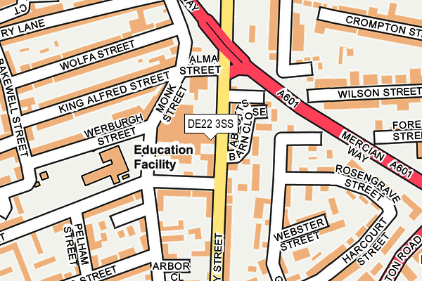
DE22 3SS is located in the Abbey electoral ward, within the unitary authority of Derby and the English Parliamentary constituency of Derby North. The Sub Integrated Care Board (ICB) Location is NHS Derby and Derbyshire ICB - 15M and the police force is Derbyshire. This postcode has been in use since August 1992.


GetTheData
Source: OS OpenMap – Local (Ordnance Survey)
Source: OS VectorMap District (Ordnance Survey)
Licence: Open Government Licence (requires attribution)
| Easting | 434831 |
| Northing | 335789 |
| Latitude | 52.918415 |
| Longitude | -1.483421 |
GetTheData
Source: Open Postcode Geo
Licence: Open Government Licence
| Country | England |
| Postcode District | DE22 |
| ➜ DE22 open data dashboard ➜ See where DE22 is on a map ➜ Where is Derby? | |
GetTheData
Source: Land Registry Price Paid Data
Licence: Open Government Licence
Elevation or altitude of DE22 3SS as distance above sea level:
| Metres | Feet | |
|---|---|---|
| Elevation | 60m | 197ft |
Elevation is measured from the approximate centre of the postcode, to the nearest point on an OS contour line from OS Terrain 50, which has contour spacing of ten vertical metres.
➜ How high above sea level am I? Find the elevation of your current position using your device's GPS.
GetTheData
Source: Open Postcode Elevation
Licence: Open Government Licence
| Ward | Abbey |
| Constituency | Derby North |
GetTheData
Source: ONS Postcode Database
Licence: Open Government Licence
| December 2023 | Public order | On or near Wilmot Street | 498m |
| December 2023 | Theft from the person | On or near Wilmot Street | 498m |
| December 2023 | Violence and sexual offences | On or near Wilmot Street | 498m |
| ➜ Get more crime data in our Crime section | |||
GetTheData
Source: data.police.uk
Licence: Open Government Licence
| Abbotts Barn Close (Abbey Street) | Derby | 18m |
| Abbotts Barn Close (Abbey Street) | Derby | 33m |
| Monk Street (Stockbrook Street) | St Lukes | 166m |
| Macklin Street (Abbey Street) | Derby | 254m |
| Macklin Street (Abbey Street) | Derby | 278m |
| Derby Station | 1.4km |
| Peartree Station | 2.5km |
| Spondon Station | 4.9km |
GetTheData
Source: NaPTAN
Licence: Open Government Licence
GetTheData
Source: ONS Postcode Database
Licence: Open Government Licence


➜ Get more ratings from the Food Standards Agency
GetTheData
Source: Food Standards Agency
Licence: FSA terms & conditions
| Last Collection | |||
|---|---|---|---|
| Location | Mon-Fri | Sat | Distance |
| Wolfa Street | 17:30 | 12:00 | 163m |
| Stockbrook Street | 17:30 | 12:00 | 229m |
| Grey Street | 18:30 | 11:30 | 270m |
GetTheData
Source: Dracos
Licence: Creative Commons Attribution-ShareAlike
| Facility | Distance |
|---|---|
| Becket Primary School Monk Street, Derby Grass Pitches | 141m |
| St Joseph's Catholic Primary School Mill Hill Lane, Derby Grass Pitches | 572m |
| Stockbrook Park Stockbrook Street, Derby Grass Pitches | 591m |
GetTheData
Source: Active Places
Licence: Open Government Licence
| School | Phase of Education | Distance |
|---|---|---|
| Becket Primary School Monk Street, Derby, DE22 3QB | Primary | 133m |
| St Joseph's Catholic Voluntary Academy St Joseph's , Mill Hill Lane, Derby, DE23 6SB | Primary | 539m |
| Derby Cathedral School Great Northern Road, Derby, DE1 1LR | Secondary | 711m |
GetTheData
Source: Edubase
Licence: Open Government Licence
The below table lists the International Territorial Level (ITL) codes (formerly Nomenclature of Territorial Units for Statistics (NUTS) codes) and Local Administrative Units (LAU) codes for DE22 3SS:
| ITL 1 Code | Name |
|---|---|
| TLF | East Midlands (England) |
| ITL 2 Code | Name |
| TLF1 | Derbyshire and Nottinghamshire |
| ITL 3 Code | Name |
| TLF11 | Derby |
| LAU 1 Code | Name |
| E06000015 | Derby |
GetTheData
Source: ONS Postcode Directory
Licence: Open Government Licence
The below table lists the Census Output Area (OA), Lower Layer Super Output Area (LSOA), and Middle Layer Super Output Area (MSOA) for DE22 3SS:
| Code | Name | |
|---|---|---|
| OA | E00067945 | |
| LSOA | E01013456 | Derby 013C |
| MSOA | E02002808 | Derby 013 |
GetTheData
Source: ONS Postcode Directory
Licence: Open Government Licence
| DE22 3SN | Abbotts Barn Close | 63m |
| DE22 3QE | Monk Street | 64m |
| DE22 3QB | Monk Street | 100m |
| DE22 3ST | Abbey Street | 103m |
| DE22 3SU | Abbey Street | 106m |
| DE1 1PD | Gerard Street | 133m |
| DE22 3UA | Woods Lane | 154m |
| DE1 1PH | Gerard Street | 164m |
| DE22 3WP | Stockbrook Street | 169m |
| DE22 3SP | Abbey Street | 169m |
GetTheData
Source: Open Postcode Geo; Land Registry Price Paid Data
Licence: Open Government Licence