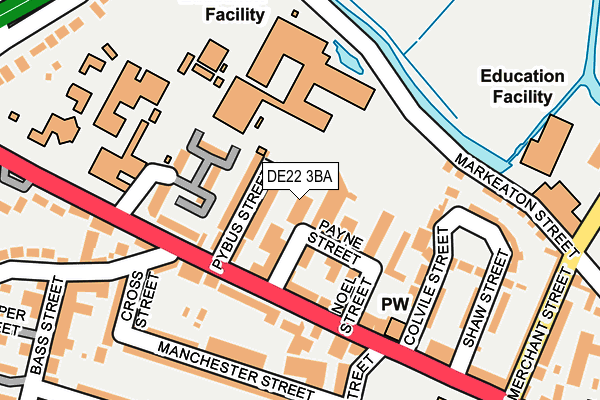
DE22 3BA lies on Chandos Pole Street in Derby. DE22 3BA is located in the Darley electoral ward, within the unitary authority of Derby and the English Parliamentary constituency of Derby North. The Sub Integrated Care Board (ICB) Location is NHS Derby and Derbyshire ICB - 15M and the police force is Derbyshire. This postcode has been in use since August 1992.


GetTheData
Source: OS OpenMap – Local (Ordnance Survey)
Source: OS VectorMap District (Ordnance Survey)
Licence: Open Government Licence (requires attribution)
| Easting | 433850 |
| Northing | 336864 |
| Latitude | 52.928141 |
| Longitude | -1.497898 |
GetTheData
Source: Open Postcode Geo
Licence: Open Government Licence
| Street | Chandos Pole Street |
| Town/City | Derby |
| Country | England |
| Postcode District | DE22 |
| ➜ DE22 open data dashboard ➜ See where DE22 is on a map ➜ Where is Derby? | |
GetTheData
Source: Land Registry Price Paid Data
Licence: Open Government Licence
Elevation or altitude of DE22 3BA as distance above sea level:
| Metres | Feet | |
|---|---|---|
| Elevation | 60m | 197ft |
Elevation is measured from the approximate centre of the postcode, to the nearest point on an OS contour line from OS Terrain 50, which has contour spacing of ten vertical metres.
➜ How high above sea level am I? Find the elevation of your current position using your device's GPS.
GetTheData
Source: Open Postcode Elevation
Licence: Open Government Licence
| Ward | Darley |
| Constituency | Derby North |
GetTheData
Source: ONS Postcode Database
Licence: Open Government Licence
HOMEWARE HOUSE, 1, CHANDOS POLE STREET, DERBY, DE22 3BA 1998 25 NOV £36,000 |
GetTheData
Source: HM Land Registry Price Paid Data
Licence: Contains HM Land Registry data © Crown copyright and database right 2024. This data is licensed under the Open Government Licence v3.0.
| January 2024 | Other theft | On or near Further/Higher Educational Building | 117m |
| January 2024 | Public order | On or near Further/Higher Educational Building | 117m |
| December 2023 | Anti-social behaviour | On or near Further/Higher Educational Building | 117m |
| ➜ Chandos Pole Street crime map and outcomes | |||
GetTheData
Source: data.police.uk
Licence: Open Government Licence
| University Markeaton Street (Pybus Street) | Markeaton | 71m |
| Windmill Hill Lane (Ashbourne Road) | Markeaton | 131m |
| Shaw Street (Ashbourne Road) | Markeaton | 150m |
| Windmill Hill Lane (Ashbourne Road) | Markeaton | 186m |
| Shaw Street (Ashbourne Road) | Markeaton | 215m |
| Derby Station | 2.7km |
| Peartree Station | 3.8km |
GetTheData
Source: NaPTAN
Licence: Open Government Licence
GetTheData
Source: ONS Postcode Database
Licence: Open Government Licence


➜ Get more ratings from the Food Standards Agency
GetTheData
Source: Food Standards Agency
Licence: FSA terms & conditions
| Last Collection | |||
|---|---|---|---|
| Location | Mon-Fri | Sat | Distance |
| Ashbourne Road Post Office | 17:30 | 12:00 | 98m |
| Markeaton Park | 17:30 | 10:30 | 236m |
| Radbourne Street, Derby | 17:30 | 10:30 | 367m |
GetTheData
Source: Dracos
Licence: Creative Commons Attribution-ShareAlike
| Facility | Distance |
|---|---|
| Royal School For The Deaf Derby Ashbourne Road, Derby Grass Pitches, Sports Hall | 213m |
| Ashgate Primary School Ashbourne Road, Derby Grass Pitches, Sports Hall | 267m |
| Markeaton Rec Mackworth Road, Derby Grass Pitches | 417m |
GetTheData
Source: Active Places
Licence: Open Government Licence
| School | Phase of Education | Distance |
|---|---|---|
| Royal School for the Deaf Derby Ashbourne Road, Derby, DE22 3BH | Not applicable | 213m |
| Ashgate Primary School Ashbourne Road, Derby, DE22 3FS | Primary | 269m |
| Jasmine Hall School 51 Ashbourne Road, Derby, DE22 3FS | Not applicable | 409m |
GetTheData
Source: Edubase
Licence: Open Government Licence
The below table lists the International Territorial Level (ITL) codes (formerly Nomenclature of Territorial Units for Statistics (NUTS) codes) and Local Administrative Units (LAU) codes for DE22 3BA:
| ITL 1 Code | Name |
|---|---|
| TLF | East Midlands (England) |
| ITL 2 Code | Name |
| TLF1 | Derbyshire and Nottinghamshire |
| ITL 3 Code | Name |
| TLF11 | Derby |
| LAU 1 Code | Name |
| E06000015 | Derby |
GetTheData
Source: ONS Postcode Directory
Licence: Open Government Licence
The below table lists the Census Output Area (OA), Lower Layer Super Output Area (LSOA), and Middle Layer Super Output Area (MSOA) for DE22 3BA:
| Code | Name | |
|---|---|---|
| OA | E00068279 | |
| LSOA | E01013522 | Derby 008A |
| MSOA | E02002803 | Derby 008 |
GetTheData
Source: ONS Postcode Directory
Licence: Open Government Licence
| DE22 3BD | Pybus Street | 46m |
| DE22 3AZ | Kingsmead Industrial Estate | 52m |
| DE22 3AH | Ashbourne Road | 112m |
| DE22 3AG | Ashbourne Road | 114m |
| DE22 3FW | Ashbourne Road | 120m |
| DE22 3BB | Kniveton Close | 126m |
| DE22 3AT | Colvile Street | 145m |
| DE22 3HF | Shaws Green | 161m |
| DE22 3GB | Manchester Street | 172m |
| DE22 3AW | Markeaton Street | 184m |
GetTheData
Source: Open Postcode Geo; Land Registry Price Paid Data
Licence: Open Government Licence