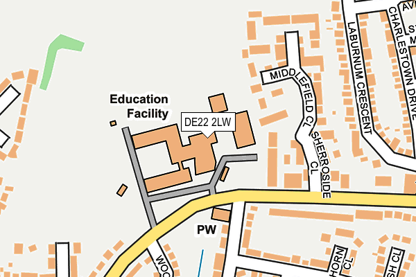
DE22 2LW is located in the Allestree electoral ward, within the unitary authority of Derby and the English Parliamentary constituency of Mid Derbyshire. The Sub Integrated Care Board (ICB) Location is NHS Derby and Derbyshire ICB - 15M and the police force is Derbyshire. This postcode has been in use since August 1992.


GetTheData
Source: OS OpenMap – Local (Ordnance Survey)
Source: OS VectorMap District (Ordnance Survey)
Licence: Open Government Licence (requires attribution)
| Easting | 433643 |
| Northing | 339751 |
| Latitude | 52.954105 |
| Longitude | -1.500679 |
GetTheData
Source: Open Postcode Geo
Licence: Open Government Licence
| Country | England |
| Postcode District | DE22 |
| ➜ DE22 open data dashboard ➜ See where DE22 is on a map ➜ Where is Derby? | |
GetTheData
Source: Land Registry Price Paid Data
Licence: Open Government Licence
Elevation or altitude of DE22 2LW as distance above sea level:
| Metres | Feet | |
|---|---|---|
| Elevation | 100m | 328ft |
Elevation is measured from the approximate centre of the postcode, to the nearest point on an OS contour line from OS Terrain 50, which has contour spacing of ten vertical metres.
➜ How high above sea level am I? Find the elevation of your current position using your device's GPS.
GetTheData
Source: Open Postcode Elevation
Licence: Open Government Licence
| Ward | Allestree |
| Constituency | Mid Derbyshire |
GetTheData
Source: ONS Postcode Database
Licence: Open Government Licence
| December 2023 | Violence and sexual offences | On or near Middlefield Close | 159m |
| November 2023 | Other crime | On or near Middlefield Close | 159m |
| November 2023 | Vehicle crime | On or near Middlefield Close | 159m |
| ➜ Get more crime data in our Crime section | |||
GetTheData
Source: data.police.uk
Licence: Open Government Licence
| Woodlands School (Blenheim Drive) | Allestree | 74m |
| Woodlands School (Blenheim Drive) | Allestree | 95m |
| Askerfield Avenue (Blenheim Drive) | Allestree | 261m |
| Askerfield Avenue (Blenheim Drive) | Allestree | 315m |
| Blenheim Parade (Blenheim Drive) | Allestree | 372m |
| Duffield Station | 3.9km |
| Derby Station | 4.9km |
GetTheData
Source: NaPTAN
Licence: Open Government Licence
GetTheData
Source: ONS Postcode Database
Licence: Open Government Licence


➜ Get more ratings from the Food Standards Agency
GetTheData
Source: Food Standards Agency
Licence: FSA terms & conditions
| Last Collection | |||
|---|---|---|---|
| Location | Mon-Fri | Sat | Distance |
| Askerfield Avenue | 17:30 | 11:00 | 267m |
| Hollies Road | 17:30 | 11:00 | 317m |
| Blenheim Parade Post Office | 17:30 | 11:30 | 359m |
GetTheData
Source: Dracos
Licence: Creative Commons Attribution-ShareAlike
| Facility | Distance |
|---|---|
| Allestree Woodlands School Blenheim Drive, Allestree, Derby Sports Hall, Artificial Grass Pitch, Health and Fitness Gym, Grass Pitches, Swimming Pool | 37m |
| Portway Junior School Robincroft Road, Allestree, Derby Grass Pitches | 532m |
| Allestree Recreation Ground Robincroft Road, Derby Grass Pitches | 954m |
GetTheData
Source: Active Places
Licence: Open Government Licence
| School | Phase of Education | Distance |
|---|---|---|
| Allestree Woodlands School Blenheim Drive, Allestree, Derby, DE22 2LW | Secondary | 37m |
| Portway Junior School Robincroft Road, Allestree, Derby, DE22 2GL | Primary | 532m |
| Portway Infant School Woodlands Road, Allestree, Derby, DE22 2HE | Primary | 543m |
GetTheData
Source: Edubase
Licence: Open Government Licence
The below table lists the International Territorial Level (ITL) codes (formerly Nomenclature of Territorial Units for Statistics (NUTS) codes) and Local Administrative Units (LAU) codes for DE22 2LW:
| ITL 1 Code | Name |
|---|---|
| TLF | East Midlands (England) |
| ITL 2 Code | Name |
| TLF1 | Derbyshire and Nottinghamshire |
| ITL 3 Code | Name |
| TLF11 | Derby |
| LAU 1 Code | Name |
| E06000015 | Derby |
GetTheData
Source: ONS Postcode Directory
Licence: Open Government Licence
The below table lists the Census Output Area (OA), Lower Layer Super Output Area (LSOA), and Middle Layer Super Output Area (MSOA) for DE22 2LW:
| Code | Name | |
|---|---|---|
| OA | E00068004 | |
| LSOA | E01013465 | Derby 002A |
| MSOA | E02002797 | Derby 002 |
GetTheData
Source: ONS Postcode Directory
Licence: Open Government Licence
| DE22 2JH | Kingsley Road | 127m |
| DE22 2HP | Middlefield Close | 160m |
| DE22 2HN | Sherroside Close | 164m |
| DE22 2LG | Blenheim Drive | 195m |
| DE22 2LH | Blenheim Drive | 204m |
| DE22 2LP | Woodstock Close | 209m |
| DE22 2AY | Acresview Close | 212m |
| DE22 2JJ | Kingsley Road | 240m |
| DE22 2LQ | Bancroft Drive | 249m |
| DE22 2JD | Lockwood Road | 259m |
GetTheData
Source: Open Postcode Geo; Land Registry Price Paid Data
Licence: Open Government Licence