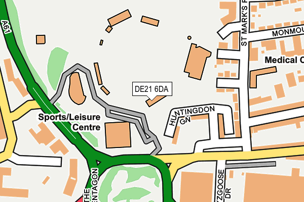
DE21 6DA is located in the Chaddesden West electoral ward, within the unitary authority of Derby and the English Parliamentary constituency of Derby North. The Sub Integrated Care Board (ICB) Location is NHS Derby and Derbyshire ICB - 15M and the police force is Derbyshire. This postcode has been in use since August 1992.


GetTheData
Source: OS OpenMap – Local (Ordnance Survey)
Source: OS VectorMap District (Ordnance Survey)
Licence: Open Government Licence (requires attribution)
| Easting | 436352 |
| Northing | 336731 |
| Latitude | 52.926783 |
| Longitude | -1.460696 |
GetTheData
Source: Open Postcode Geo
Licence: Open Government Licence
| Country | England |
| Postcode District | DE21 |
➜ See where DE21 is on a map ➜ Where is Derby? | |
GetTheData
Source: Land Registry Price Paid Data
Licence: Open Government Licence
Elevation or altitude of DE21 6DA as distance above sea level:
| Metres | Feet | |
|---|---|---|
| Elevation | 50m | 164ft |
Elevation is measured from the approximate centre of the postcode, to the nearest point on an OS contour line from OS Terrain 50, which has contour spacing of ten vertical metres.
➜ How high above sea level am I? Find the elevation of your current position using your device's GPS.
GetTheData
Source: Open Postcode Elevation
Licence: Open Government Licence
| Ward | Chaddesden West |
| Constituency | Derby North |
GetTheData
Source: ONS Postcode Database
Licence: Open Government Licence
| Wayzgoose Drive (Nottingham Road) | Chaddesden | 167m |
| Wayzgoose Drive (Nottingham Road) | Chaddesden | 215m |
| Francis Street (Beaufort Street) | Chaddesden | 351m |
| Francis Street (Beaufort Street) | Chaddesden | 374m |
| Eastgate | Derby | 410m |
| Derby Station | 1.2km |
| Peartree Station | 3.4km |
| Spondon Station | 3.7km |
GetTheData
Source: NaPTAN
Licence: Open Government Licence
GetTheData
Source: ONS Postcode Database
Licence: Open Government Licence


➜ Get more ratings from the Food Standards Agency
GetTheData
Source: Food Standards Agency
Licence: FSA terms & conditions
| Last Collection | |||
|---|---|---|---|
| Location | Mon-Fri | Sat | Distance |
| Cardigan Street | 17:30 | 11:00 | 420m |
| West Meadows Business Box | 18:30 | 429m | |
| Cranmer Road | 18:30 | 12:00 | 432m |
GetTheData
Source: Dracos
Licence: Creative Commons Attribution-ShareAlike
| Risk of DE21 6DA flooding from rivers and sea | Medium |
| ➜ DE21 6DA flood map | |
GetTheData
Source: Open Flood Risk by Postcode
Licence: Open Government Licence
The below table lists the International Territorial Level (ITL) codes (formerly Nomenclature of Territorial Units for Statistics (NUTS) codes) and Local Administrative Units (LAU) codes for DE21 6DA:
| ITL 1 Code | Name |
|---|---|
| TLF | East Midlands (England) |
| ITL 2 Code | Name |
| TLF1 | Derbyshire and Nottinghamshire |
| ITL 3 Code | Name |
| TLF11 | Derby |
| LAU 1 Code | Name |
| E06000015 | Derby |
GetTheData
Source: ONS Postcode Directory
Licence: Open Government Licence
The below table lists the Census Output Area (OA), Lower Layer Super Output Area (LSOA), and Middle Layer Super Output Area (MSOA) for DE21 6DA:
| Code | Name | |
|---|---|---|
| OA | E00068321 | |
| LSOA | E01013536 | Derby 007C |
| MSOA | E02002802 | Derby 007 |
GetTheData
Source: ONS Postcode Directory
Licence: Open Government Licence
| DE21 6AB | Huntingdon Green | 86m |
| DE21 6AF | Grandstand Road | 143m |
| DE21 6AE | Westmorland Close | 143m |
| DE21 6AJ | St Marks Road | 190m |
| DE21 6AH | St Marks Road | 193m |
| DE21 6DD | Francis Street | 272m |
| DE21 6DB | Francis Street | 273m |
| DE21 6AN | Nottingham Road | 297m |
| DE21 6BH | Beaufort Gardens | 364m |
| DE21 6AL | St Marks Road | 365m |
GetTheData
Source: Open Postcode Geo; Land Registry Price Paid Data
Licence: Open Government Licence