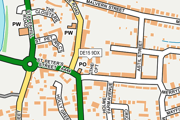
DE15 9DX is located in the Brizlincote electoral ward, within the local authority district of East Staffordshire and the English Parliamentary constituency of Burton. The Sub Integrated Care Board (ICB) Location is NHS Staffordshire and Stoke-on-Trent ICB - 05D and the police force is Staffordshire. This postcode has been in use since January 1980.


GetTheData
Source: OS OpenMap – Local (Ordnance Survey)
Source: OS VectorMap District (Ordnance Survey)
Licence: Open Government Licence (requires attribution)
| Easting | 425735 |
| Northing | 322033 |
| Latitude | 52.795253 |
| Longitude | -1.619782 |
GetTheData
Source: Open Postcode Geo
Licence: Open Government Licence
| Country | England |
| Postcode District | DE15 |
| ➜ DE15 open data dashboard ➜ See where DE15 is on a map ➜ Where is Burton upon Trent? | |
GetTheData
Source: Land Registry Price Paid Data
Licence: Open Government Licence
Elevation or altitude of DE15 9DX as distance above sea level:
| Metres | Feet | |
|---|---|---|
| Elevation | 60m | 197ft |
Elevation is measured from the approximate centre of the postcode, to the nearest point on an OS contour line from OS Terrain 50, which has contour spacing of ten vertical metres.
➜ How high above sea level am I? Find the elevation of your current position using your device's GPS.
GetTheData
Source: Open Postcode Elevation
Licence: Open Government Licence
| Ward | Brizlincote |
| Constituency | Burton |
GetTheData
Source: ONS Postcode Database
Licence: Open Government Licence
| June 2022 | Violence and sexual offences | On or near The Croft | 32m |
| June 2022 | Violence and sexual offences | On or near The Croft | 32m |
| June 2022 | Violence and sexual offences | On or near The Croft | 32m |
| ➜ Get more crime data in our Crime section | |||
GetTheData
Source: data.police.uk
Licence: Open Government Licence
| Holme Farm Avenue (Woods Lane) | Stapenhill | 105m |
| Woods Lane (Stanton Road) | Stapenhill | 125m |
| Holme Farm Avenue (Woods Lane) | Stapenhill | 140m |
| Woods Lane (Stanton Road) | Stapenhill | 156m |
| St Peters Street (Main St) | Stapenhill | 228m |
| Burton-on-Trent Station | 1.9km |
GetTheData
Source: NaPTAN
Licence: Open Government Licence
GetTheData
Source: ONS Postcode Database
Licence: Open Government Licence


➜ Get more ratings from the Food Standards Agency
GetTheData
Source: Food Standards Agency
Licence: FSA terms & conditions
| Last Collection | |||
|---|---|---|---|
| Location | Mon-Fri | Sat | Distance |
| Stapenhill Post Office | 16:00 | 12:00 | 61m |
| Malvern Street | 16:00 | 10:30 | 237m |
| Spring Terrace Road | 16:00 | 10:30 | 321m |
GetTheData
Source: Dracos
Licence: Creative Commons Attribution-ShareAlike
| Facility | Distance |
|---|---|
| Paulet High School Violet Way, Burton-on-trent Sports Hall, Grass Pitches | 619m |
| Heath Road Heath Road, Burton-on-trent Grass Pitches | 796m |
| Edge Hill Academy Sycamore Road, Sycamore Road, Burton-on-trent Grass Pitches | 836m |
GetTheData
Source: Active Places
Licence: Open Government Licence
| School | Phase of Education | Distance |
|---|---|---|
| The Violet Way Academy Violet Way, Stapenhill, Burton-on-Trent, DE15 9ES | Primary | 482m |
| Paulet High School Violet Way, Stapenhill, Burton-on-Trent, DE15 9RT | Secondary | 642m |
| Edge Hill Academy Sycamore Road, Stapenhill, Burton-on-Trent, DE15 9NX | Primary | 836m |
GetTheData
Source: Edubase
Licence: Open Government Licence
The below table lists the International Territorial Level (ITL) codes (formerly Nomenclature of Territorial Units for Statistics (NUTS) codes) and Local Administrative Units (LAU) codes for DE15 9DX:
| ITL 1 Code | Name |
|---|---|
| TLG | West Midlands (England) |
| ITL 2 Code | Name |
| TLG2 | Shropshire and Staffordshire |
| ITL 3 Code | Name |
| TLG24 | Staffordshire CC |
| LAU 1 Code | Name |
| E07000193 | East Staffordshire |
GetTheData
Source: ONS Postcode Directory
Licence: Open Government Licence
The below table lists the Census Output Area (OA), Lower Layer Super Output Area (LSOA), and Middle Layer Super Output Area (MSOA) for DE15 9DX:
| Code | Name | |
|---|---|---|
| OA | E00149894 | |
| LSOA | E01029420 | East Staffordshire 012C |
| MSOA | E02006142 | East Staffordshire 012 |
GetTheData
Source: ONS Postcode Directory
Licence: Open Government Licence
| DE15 9ED | The Croft | 28m |
| DE15 9EE | Woods Lane | 101m |
| DE15 9AW | St Peters Street | 106m |
| DE15 9DJ | Brizlincote Street | 111m |
| DE15 9BF | St Peters Court | 145m |
| DE15 9DU | Spring Terrace Road | 148m |
| DE15 9EG | Holme Farm Avenue | 168m |
| DE15 9DZ | Malvern Street | 176m |
| DE15 9GA | Holly Green | 179m |
| DE15 9EQ | Outfield Road | 182m |
GetTheData
Source: Open Postcode Geo; Land Registry Price Paid Data
Licence: Open Government Licence