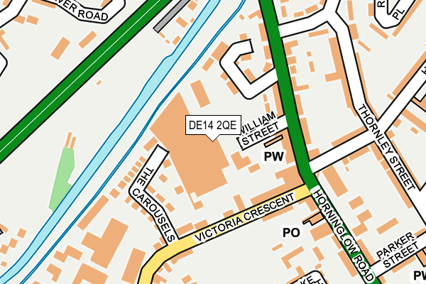
DE14 2QE is located in the Burton & Eton electoral ward, within the local authority district of East Staffordshire and the English Parliamentary constituency of Burton. The Sub Integrated Care Board (ICB) Location is NHS Staffordshire and Stoke-on-Trent ICB - 05D and the police force is Staffordshire. This postcode has been in use since January 1980.


GetTheData
Source: OS OpenMap – Local (Ordnance Survey)
Source: OS VectorMap District (Ordnance Survey)
Licence: Open Government Licence (requires attribution)
| Easting | 424309 |
| Northing | 324414 |
| Latitude | 52.816722 |
| Longitude | -1.640753 |
GetTheData
Source: Open Postcode Geo
Licence: Open Government Licence
| Country | England |
| Postcode District | DE14 |
| ➜ DE14 open data dashboard ➜ See where DE14 is on a map ➜ Where is Burton upon Trent? | |
GetTheData
Source: Land Registry Price Paid Data
Licence: Open Government Licence
Elevation or altitude of DE14 2QE as distance above sea level:
| Metres | Feet | |
|---|---|---|
| Elevation | 50m | 164ft |
Elevation is measured from the approximate centre of the postcode, to the nearest point on an OS contour line from OS Terrain 50, which has contour spacing of ten vertical metres.
➜ How high above sea level am I? Find the elevation of your current position using your device's GPS.
GetTheData
Source: Open Postcode Elevation
Licence: Open Government Licence
| Ward | Burton & Eton |
| Constituency | Burton |
GetTheData
Source: ONS Postcode Database
Licence: Open Government Licence
| January 2024 | Violence and sexual offences | On or near The Carousels | 125m |
| January 2024 | Violence and sexual offences | On or near The Carousels | 125m |
| January 2024 | Violence and sexual offences | On or near Dallow Street | 346m |
| ➜ Get more crime data in our Crime section | |||
GetTheData
Source: data.police.uk
Licence: Open Government Licence
| Victoria Crescent (Horninglow Rd) | Horninglow | 107m |
| Horninglow Road (Victoria Crescent) | Horninglow | 141m |
| The Carousels (Victoria Crescent) | Outwoods | 161m |
| The Carousels (Victoria Crescent) | Outwoods | 172m |
| The Navigation (Horninglow Rd) | Horninglow | 189m |
| Burton-on-Trent Station | 1.2km |
GetTheData
Source: NaPTAN
Licence: Open Government Licence
GetTheData
Source: ONS Postcode Database
Licence: Open Government Licence


➜ Get more ratings from the Food Standards Agency
GetTheData
Source: Food Standards Agency
Licence: FSA terms & conditions
| Last Collection | |||
|---|---|---|---|
| Location | Mon-Fri | Sat | Distance |
| Horninglow Road North P.o. | 17:30 | 11:30 | 115m |
| Wyggeston Street | 16:00 | 10:30 | 329m |
| Victoria Crescent Post Office | 17:30 | 10:30 | 348m |
GetTheData
Source: Dracos
Licence: Creative Commons Attribution-ShareAlike
| Facility | Distance |
|---|---|
| Belvedere Park Social Club (Closed) Belvedere Road, Burton-on-trent Grass Pitches | 473m |
| Scientia Academy Mona Road, Mona Road, Burton-on-trent Grass Pitches | 555m |
| Btr (Closed) Horninglow Road, Burton-on-trent Grass Pitches | 667m |
GetTheData
Source: Active Places
Licence: Open Government Licence
| School | Phase of Education | Distance |
|---|---|---|
| Horninglow Primary: A de Ferrers Trust Academy Horninglow Road North, Elford, Burton-on-Trent, DE13 0SW | Primary | 506m |
| Lansdowne: A de Ferrers Trust Academy Goodman Street, Burton-on-Trent, DE14 2RE | Primary | 509m |
| Victoria Community School Victoria Road, Burton-on-Trent, DE14 2LU | Primary | 526m |
GetTheData
Source: Edubase
Licence: Open Government Licence
The below table lists the International Territorial Level (ITL) codes (formerly Nomenclature of Territorial Units for Statistics (NUTS) codes) and Local Administrative Units (LAU) codes for DE14 2QE:
| ITL 1 Code | Name |
|---|---|
| TLG | West Midlands (England) |
| ITL 2 Code | Name |
| TLG2 | Shropshire and Staffordshire |
| ITL 3 Code | Name |
| TLG24 | Staffordshire CC |
| LAU 1 Code | Name |
| E07000193 | East Staffordshire |
GetTheData
Source: ONS Postcode Directory
Licence: Open Government Licence
The below table lists the Census Output Area (OA), Lower Layer Super Output Area (LSOA), and Middle Layer Super Output Area (MSOA) for DE14 2QE:
| Code | Name | |
|---|---|---|
| OA | E00149936 | |
| LSOA | E01029426 | East Staffordshire 008A |
| MSOA | E02006138 | East Staffordshire 008 |
GetTheData
Source: ONS Postcode Directory
Licence: Open Government Licence
| DE14 2PT | Horninglow Road | 104m |
| DE14 2QG | The Carousels | 108m |
| DE14 2QD | Victoria Crescent | 122m |
| DE14 2QF | Victoria Crescent | 130m |
| DE14 2PX | Horninglow Road | 131m |
| DE14 2ST | Hunter Street | 193m |
| DE14 2QP | Thornley Street | 225m |
| DE14 2QJ | Blakeholme Court | 228m |
| DE14 2PW | Dallow Close | 248m |
| DE14 2PY | Horninglow Road | 253m |
GetTheData
Source: Open Postcode Geo; Land Registry Price Paid Data
Licence: Open Government Licence