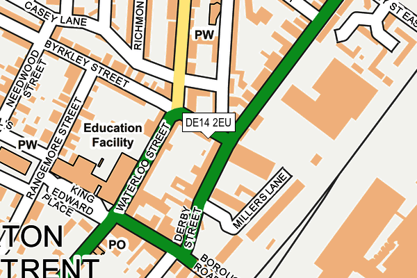
DE14 2EU lies on Byrkley Court in Burton-on-trent. DE14 2EU is located in the Shobnall electoral ward, within the local authority district of East Staffordshire and the English Parliamentary constituency of Burton. The Sub Integrated Care Board (ICB) Location is NHS Staffordshire and Stoke-on-Trent ICB - 05D and the police force is Staffordshire. This postcode has been in use since January 1991.


GetTheData
Source: OS OpenMap – Local (Ordnance Survey)
Source: OS VectorMap District (Ordnance Survey)
Licence: Open Government Licence (requires attribution)
| Easting | 424185 |
| Northing | 323492 |
| Latitude | 52.808439 |
| Longitude | -1.642661 |
GetTheData
Source: Open Postcode Geo
Licence: Open Government Licence
| Street | Byrkley Court |
| Town/City | Burton-on-trent |
| Country | England |
| Postcode District | DE14 |
➜ See where DE14 is on a map ➜ Where is Burton upon Trent? | |
GetTheData
Source: Land Registry Price Paid Data
Licence: Open Government Licence
Elevation or altitude of DE14 2EU as distance above sea level:
| Metres | Feet | |
|---|---|---|
| Elevation | 50m | 164ft |
Elevation is measured from the approximate centre of the postcode, to the nearest point on an OS contour line from OS Terrain 50, which has contour spacing of ten vertical metres.
➜ How high above sea level am I? Find the elevation of your current position using your device's GPS.
GetTheData
Source: Open Postcode Elevation
Licence: Open Government Licence
| Ward | Shobnall |
| Constituency | Burton |
GetTheData
Source: ONS Postcode Database
Licence: Open Government Licence
| Lidl Store (Derby St) | Shobnall | 66m |
| Princess Street (Derby Street) | Shobnall | 67m |
| Borough Road (Wellington Street) | Shobnall | 113m |
| Casey Lane (Waterloo Street) | Shobnall | 114m |
| Casey Lane (Waterloo Street) | Shobnall | 147m |
| Burton-on-Trent Station | 0.3km |
GetTheData
Source: NaPTAN
Licence: Open Government Licence
| Percentage of properties with Next Generation Access | 100.0% |
| Percentage of properties with Superfast Broadband | 100.0% |
| Percentage of properties with Ultrafast Broadband | 0.0% |
| Percentage of properties with Full Fibre Broadband | 0.0% |
Superfast Broadband is between 30Mbps and 300Mbps
Ultrafast Broadband is > 300Mbps
| Percentage of properties unable to receive 2Mbps | 0.0% |
| Percentage of properties unable to receive 5Mbps | 0.0% |
| Percentage of properties unable to receive 10Mbps | 0.0% |
| Percentage of properties unable to receive 30Mbps | 0.0% |
GetTheData
Source: Ofcom
Licence: Ofcom Terms of Use (requires attribution)
GetTheData
Source: ONS Postcode Database
Licence: Open Government Licence


➜ Get more ratings from the Food Standards Agency
GetTheData
Source: Food Standards Agency
Licence: FSA terms & conditions
| Last Collection | |||
|---|---|---|---|
| Location | Mon-Fri | Sat | Distance |
| Waterloo Street | 17:30 | 11:30 | 107m |
| Wellington Street Post Office | 17:30 | 11:45 | 236m |
| Station Street | 17:30 | 12:00 | 325m |
GetTheData
Source: Dracos
Licence: Creative Commons Attribution-ShareAlike
| Risk of DE14 2EU flooding from rivers and sea | Low |
| ➜ DE14 2EU flood map | |
GetTheData
Source: Open Flood Risk by Postcode
Licence: Open Government Licence
The below table lists the International Territorial Level (ITL) codes (formerly Nomenclature of Territorial Units for Statistics (NUTS) codes) and Local Administrative Units (LAU) codes for DE14 2EU:
| ITL 1 Code | Name |
|---|---|
| TLG | West Midlands (England) |
| ITL 2 Code | Name |
| TLG2 | Shropshire and Staffordshire |
| ITL 3 Code | Name |
| TLG24 | Staffordshire CC |
| LAU 1 Code | Name |
| E07000193 | East Staffordshire |
GetTheData
Source: ONS Postcode Directory
Licence: Open Government Licence
The below table lists the Census Output Area (OA), Lower Layer Super Output Area (LSOA), and Middle Layer Super Output Area (MSOA) for DE14 2EU:
| Code | Name | |
|---|---|---|
| OA | E00168349 | |
| LSOA | E01029445 | East Staffordshire 009A |
| MSOA | E02006139 | East Staffordshire 009 |
GetTheData
Source: ONS Postcode Directory
Licence: Open Government Licence
| DE14 2LA | Derby Street | 57m |
| DE14 2LJ | Derby Street | 60m |
| DE14 2NJ | Waterloo Street | 81m |
| DE14 2NA | Waterloo Street | 89m |
| DE14 2EG | Byrkley Street | 118m |
| DE14 2NT | Princess Street | 134m |
| DE14 2LD | Derby Street | 138m |
| DE14 2NS | Millers Lane | 142m |
| DE14 2NB | Waterloo Street | 166m |
| DE14 2DA | Borough Road | 174m |
GetTheData
Source: Open Postcode Geo; Land Registry Price Paid Data
Licence: Open Government Licence