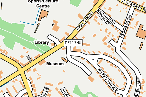
DE12 7HU lies on Mannings Terrace in Measham, Swadlincote. DE12 7HU is located in the Measham South electoral ward, within the local authority district of North West Leicestershire and the English Parliamentary constituency of North West Leicestershire. The Sub Integrated Care Board (ICB) Location is NHS Leicester, Leicestershire and Rutland ICB - 04V and the police force is Leicestershire. This postcode has been in use since January 1980.


GetTheData
Source: OS OpenMap – Local (Ordnance Survey)
Source: OS VectorMap District (Ordnance Survey)
Licence: Open Government Licence (requires attribution)
| Easting | 433283 |
| Northing | 311942 |
| Latitude | 52.704149 |
| Longitude | -1.508861 |
GetTheData
Source: Open Postcode Geo
Licence: Open Government Licence
| Street | Mannings Terrace |
| Locality | Measham |
| Town/City | Swadlincote |
| Country | England |
| Postcode District | DE12 |
| ➜ DE12 open data dashboard ➜ See where DE12 is on a map ➜ Where is Measham? | |
GetTheData
Source: Land Registry Price Paid Data
Licence: Open Government Licence
Elevation or altitude of DE12 7HU as distance above sea level:
| Metres | Feet | |
|---|---|---|
| Elevation | 90m | 295ft |
Elevation is measured from the approximate centre of the postcode, to the nearest point on an OS contour line from OS Terrain 50, which has contour spacing of ten vertical metres.
➜ How high above sea level am I? Find the elevation of your current position using your device's GPS.
GetTheData
Source: Open Postcode Elevation
Licence: Open Government Licence
| Ward | Measham South |
| Constituency | North West Leicestershire |
GetTheData
Source: ONS Postcode Database
Licence: Open Government Licence
| January 2024 | Drugs | On or near Cophills Close | 226m |
| January 2024 | Vehicle crime | On or near Parking Area | 255m |
| December 2023 | Violence and sexual offences | On or near Parking Area | 255m |
| ➜ Get more crime data in our Crime section | |||
GetTheData
Source: data.police.uk
Licence: Open Government Licence
| Library (High Street) | Measham | 122m |
| Navigation Street (High Street) | Measham | 154m |
| Burton Road (High Street) | Measham | 170m |
| Navigation Street (High Street) | Measham | 188m |
| Tamworth Road (Burton Road) | Measham | 252m |
GetTheData
Source: NaPTAN
Licence: Open Government Licence
| Percentage of properties with Next Generation Access | 100.0% |
| Percentage of properties with Superfast Broadband | 100.0% |
| Percentage of properties with Ultrafast Broadband | 100.0% |
| Percentage of properties with Full Fibre Broadband | 0.0% |
Superfast Broadband is between 30Mbps and 300Mbps
Ultrafast Broadband is > 300Mbps
| Percentage of properties unable to receive 2Mbps | 0.0% |
| Percentage of properties unable to receive 5Mbps | 0.0% |
| Percentage of properties unable to receive 10Mbps | 0.0% |
| Percentage of properties unable to receive 30Mbps | 0.0% |
GetTheData
Source: Ofcom
Licence: Ofcom Terms of Use (requires attribution)
GetTheData
Source: ONS Postcode Database
Licence: Open Government Licence


➜ Get more ratings from the Food Standards Agency
GetTheData
Source: Food Standards Agency
Licence: FSA terms & conditions
| Last Collection | |||
|---|---|---|---|
| Location | Mon-Fri | Sat | Distance |
| Measham So | 16:00 | 11:45 | 326m |
| Atherstone Road | 16:00 | 12:00 | 355m |
| Dyson Close | 16:00 | 11:45 | 668m |
GetTheData
Source: Dracos
Licence: Creative Commons Attribution-ShareAlike
| Facility | Distance |
|---|---|
| Measham Community And Recreation Centre High Street, Measham, Swadlincote Sports Hall, Health and Fitness Gym, Grass Pitches, Artificial Grass Pitch | 183m |
| Bosworth Road Recreation Ground Bosworth Road, Measham, Swadlincote Grass Pitches | 347m |
| Oakthorpe Recreation Ground Measham Road, Oakthorpe, Swadlincote Grass Pitches, Artificial Grass Pitch | 1.4km |
GetTheData
Source: Active Places
Licence: Open Government Licence
| School | Phase of Education | Distance |
|---|---|---|
| Measham Church of England Primary School Bosworth Road, Measham, Swadlincote, DE12 7LG | Primary | 296m |
| St Charles Catholic Primary Voluntary Academy Bosworth Road, Measham, Swadlincote, DE12 7LQ | Primary | 488m |
| Oakthorpe Primary School School Street, Oakthorpe, Swadlincote, DE12 7RE | Primary | 1.4km |
GetTheData
Source: Edubase
Licence: Open Government Licence
The below table lists the International Territorial Level (ITL) codes (formerly Nomenclature of Territorial Units for Statistics (NUTS) codes) and Local Administrative Units (LAU) codes for DE12 7HU:
| ITL 1 Code | Name |
|---|---|
| TLF | East Midlands (England) |
| ITL 2 Code | Name |
| TLF2 | Leicestershire, Rutland and Northamptonshire |
| ITL 3 Code | Name |
| TLF22 | Leicestershire CC and Rutland |
| LAU 1 Code | Name |
| E07000134 | North West Leicestershire |
GetTheData
Source: ONS Postcode Directory
Licence: Open Government Licence
The below table lists the Census Output Area (OA), Lower Layer Super Output Area (LSOA), and Middle Layer Super Output Area (MSOA) for DE12 7HU:
| Code | Name | |
|---|---|---|
| OA | E00131678 | |
| LSOA | E01025949 | North West Leicestershire 012D |
| MSOA | E02005408 | North West Leicestershire 012 |
GetTheData
Source: ONS Postcode Directory
Licence: Open Government Licence
| DE12 7HW | Doctors Walk | 63m |
| DE12 7HR | High Street | 82m |
| DE12 7HX | Oddfellows Row | 105m |
| DE12 7LX | Buckley Close | 176m |
| DE12 7LT | Wilkes Avenue | 178m |
| DE12 7HL | Uplands Road | 184m |
| DE12 7LZ | Cophills Close | 189m |
| DE12 7LW | Navigation Street | 190m |
| DE12 7LS | Wilkes Avenue | 194m |
| DE12 7LR | Wilkes Avenue | 209m |
GetTheData
Source: Open Postcode Geo; Land Registry Price Paid Data
Licence: Open Government Licence