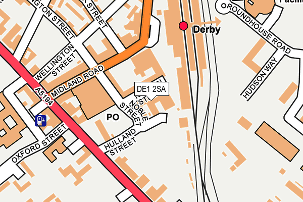
DE1 2SA is located in the Arboretum electoral ward, within the unitary authority of Derby and the English Parliamentary constituency of Derby South. The Sub Integrated Care Board (ICB) Location is NHS Derby and Derbyshire ICB - 15M and the police force is Derbyshire. This postcode has been in use since July 2009.


GetTheData
Source: OS OpenMap – Local (Ordnance Survey)
Source: OS VectorMap District (Ordnance Survey)
Licence: Open Government Licence (requires attribution)
| Easting | 436184 |
| Northing | 335392 |
| Latitude | 52.914758 |
| Longitude | -1.463343 |
GetTheData
Source: Open Postcode Geo
Licence: Open Government Licence
| Country | England |
| Postcode District | DE1 |
| ➜ DE1 open data dashboard ➜ See where DE1 is on a map ➜ Where is Derby? | |
GetTheData
Source: Land Registry Price Paid Data
Licence: Open Government Licence
Elevation or altitude of DE1 2SA as distance above sea level:
| Metres | Feet | |
|---|---|---|
| Elevation | 50m | 164ft |
Elevation is measured from the approximate centre of the postcode, to the nearest point on an OS contour line from OS Terrain 50, which has contour spacing of ten vertical metres.
➜ How high above sea level am I? Find the elevation of your current position using your device's GPS.
GetTheData
Source: Open Postcode Elevation
Licence: Open Government Licence
| Ward | Arboretum |
| Constituency | Derby South |
GetTheData
Source: ONS Postcode Database
Licence: Open Government Licence
| January 2024 | Anti-social behaviour | On or near Nelson Street | 97m |
| January 2024 | Other theft | On or near Nelson Street | 97m |
| January 2024 | Violence and sexual offences | On or near Bloomfield Close | 390m |
| ➜ Get more crime data in our Crime section | |||
GetTheData
Source: data.police.uk
Licence: Open Government Licence
| Railway Station (Railway Terrace) | Derby | 142m |
| Railway Station (Railway Terrace) | Derby | 163m |
| Bloomfield Street (London Road) | Derby | 166m |
| Bloomfield Street (London Road) | Derby | 176m |
| Midland Road | Derby | 208m |
| Derby Station | 0.2km |
| Peartree Station | 2.1km |
| Spondon Station | 3.5km |
GetTheData
Source: NaPTAN
Licence: Open Government Licence
GetTheData
Source: ONS Postcode Database
Licence: Open Government Licence


➜ Get more ratings from the Food Standards Agency
GetTheData
Source: Food Standards Agency
Licence: FSA terms & conditions
| Last Collection | |||
|---|---|---|---|
| Location | Mon-Fri | Sat | Distance |
| Midland Station | 18:30 | 12:30 | 166m |
| Midland Road Head Post Office | 18:30 | 15:00 | 186m |
| Midland Road Head Post Office | 18:30 | 15:00 | 191m |
GetTheData
Source: Dracos
Licence: Creative Commons Attribution-ShareAlike
| Facility | Distance |
|---|---|
| Derby College (Johnson Building) Locomotive Way, Derby Sports Hall, Health and Fitness Gym, Studio | 222m |
| La Fitness (Derby) (Closed) Carrington Street, Derby Health and Fitness Gym, Swimming Pool, Studio, Squash Courts | 493m |
| David Lloyd (Derby) Riverside Road, Pride Park, Derby Sports Hall, Swimming Pool, Health and Fitness Gym, Indoor Tennis Centre, Studio, Squash Courts, Outdoor Tennis Courts | 496m |
GetTheData
Source: Active Places
Licence: Open Government Licence
| School | Phase of Education | Distance |
|---|---|---|
| UTC Derby Pride Park Locomotive Way, Derby, DE24 8PU | Secondary | 307m |
| Derby College The Roundhouse, Roundhouse Road, Pride Park, Derby, DE24 8JE | 16 plus | 327m |
| Castleward Spencer Academy Canal Street, Derby, DE1 2RJ | Primary | 426m |
GetTheData
Source: Edubase
Licence: Open Government Licence
The below table lists the International Territorial Level (ITL) codes (formerly Nomenclature of Territorial Units for Statistics (NUTS) codes) and Local Administrative Units (LAU) codes for DE1 2SA:
| ITL 1 Code | Name |
|---|---|
| TLF | East Midlands (England) |
| ITL 2 Code | Name |
| TLF1 | Derbyshire and Nottinghamshire |
| ITL 3 Code | Name |
| TLF11 | Derby |
| LAU 1 Code | Name |
| E06000015 | Derby |
GetTheData
Source: ONS Postcode Directory
Licence: Open Government Licence
The below table lists the Census Output Area (OA), Lower Layer Super Output Area (LSOA), and Middle Layer Super Output Area (MSOA) for DE1 2SA:
| Code | Name | |
|---|---|---|
| OA | E00171186 | |
| LSOA | E01033167 | Derby 018G |
| MSOA | E02002813 | Derby 018 |
GetTheData
Source: ONS Postcode Directory
Licence: Open Government Licence
| DE1 2NH | Carrington Street | 103m |
| DE1 2SU | London Road | 190m |
| DE1 2SP | Midland Road | 203m |
| DE1 2SN | Midland Road | 216m |
| DE1 2SR | London Road | 245m |
| DE1 2RR | Midland Place | 246m |
| DE1 2LZ | Wellington Crescent | 263m |
| DE1 2NE | Bemrose Court | 272m |
| DE1 2LY | Carrington Street | 275m |
| DE1 2RX | Leeds Place | 282m |
GetTheData
Source: Open Postcode Geo; Land Registry Price Paid Data
Licence: Open Government Licence