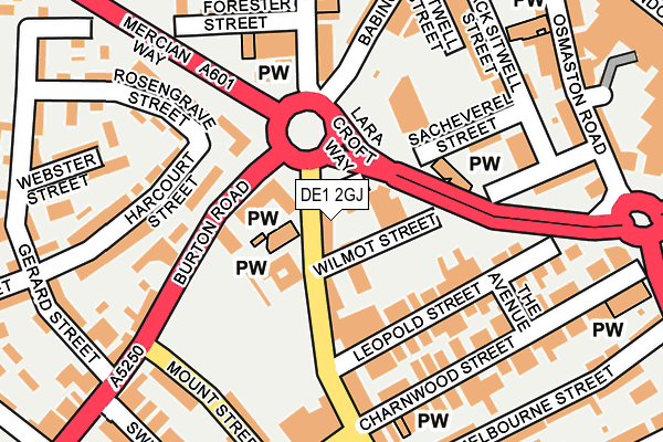
DE1 2GJ lies on Normanton Road in Derby. DE1 2GJ is located in the Arboretum electoral ward, within the unitary authority of Derby and the English Parliamentary constituency of Derby South. The Sub Integrated Care Board (ICB) Location is NHS Derby and Derbyshire ICB - 15M and the police force is Derbyshire. This postcode has been in use since January 1980.


GetTheData
Source: OS OpenMap – Local (Ordnance Survey)
Source: OS VectorMap District (Ordnance Survey)
Licence: Open Government Licence (requires attribution)
| Easting | 435201 |
| Northing | 335615 |
| Latitude | 52.916827 |
| Longitude | -1.477937 |
GetTheData
Source: Open Postcode Geo
Licence: Open Government Licence
| Street | Normanton Road |
| Town/City | Derby |
| Country | England |
| Postcode District | DE1 |
| ➜ DE1 open data dashboard ➜ See where DE1 is on a map ➜ Where is Derby? | |
GetTheData
Source: Land Registry Price Paid Data
Licence: Open Government Licence
Elevation or altitude of DE1 2GJ as distance above sea level:
| Metres | Feet | |
|---|---|---|
| Elevation | 60m | 197ft |
Elevation is measured from the approximate centre of the postcode, to the nearest point on an OS contour line from OS Terrain 50, which has contour spacing of ten vertical metres.
➜ How high above sea level am I? Find the elevation of your current position using your device's GPS.
GetTheData
Source: Open Postcode Elevation
Licence: Open Government Licence
| Ward | Arboretum |
| Constituency | Derby South |
GetTheData
Source: ONS Postcode Database
Licence: Open Government Licence
| January 2024 | Anti-social behaviour | On or near Normanton Road | 407m |
| January 2024 | Burglary | On or near Normanton Road | 407m |
| January 2024 | Burglary | On or near Normanton Road | 407m |
| ➜ Normanton Road crime map and outcomes | |||
GetTheData
Source: data.police.uk
Licence: Open Government Licence
| Leopold Street (Normanton Road) | Derby | 47m |
| Leopold Street (Normanton Road) | Derby | 71m |
| Mount Street (Burton Road) | Derby | 112m |
| Mount Street (Burton Road) | Derby | 128m |
| Lara Croft Way | Derby | 187m |
| Derby Station | 1km |
| Peartree Station | 2.2km |
| Spondon Station | 4.5km |
GetTheData
Source: NaPTAN
Licence: Open Government Licence
| Percentage of properties with Next Generation Access | 100.0% |
| Percentage of properties with Superfast Broadband | 100.0% |
| Percentage of properties with Ultrafast Broadband | 100.0% |
| Percentage of properties with Full Fibre Broadband | 0.0% |
Superfast Broadband is between 30Mbps and 300Mbps
Ultrafast Broadband is > 300Mbps
| Percentage of properties unable to receive 2Mbps | 0.0% |
| Percentage of properties unable to receive 5Mbps | 0.0% |
| Percentage of properties unable to receive 10Mbps | 0.0% |
| Percentage of properties unable to receive 30Mbps | 0.0% |
GetTheData
Source: Ofcom
Licence: Ofcom Terms of Use (requires attribution)
GetTheData
Source: ONS Postcode Database
Licence: Open Government Licence


➜ Get more ratings from the Food Standards Agency
GetTheData
Source: Food Standards Agency
Licence: FSA terms & conditions
| Last Collection | |||
|---|---|---|---|
| Location | Mon-Fri | Sat | Distance |
| Babington Lane Post Office | 18:30 | 11:30 | 189m |
| The Avenue | 18:30 | 11:00 | 199m |
| Hartington Street | 17:30 | 11:00 | 320m |
GetTheData
Source: Dracos
Licence: Creative Commons Attribution-ShareAlike
| Facility | Distance |
|---|---|
| The Gym Group (Derby) Normanton Road, Derby Health and Fitness Gym | 301m |
| Puregym (Derby) St. Peters Street, Derby Health and Fitness Gym, Studio | 360m |
| St Joseph's Catholic Primary School Mill Hill Lane, Derby Grass Pitches | 518m |
GetTheData
Source: Active Places
Licence: Open Government Licence
| School | Phase of Education | Distance |
|---|---|---|
| St Joseph's Catholic Voluntary Academy St Joseph's , Mill Hill Lane, Derby, DE23 6SB | Primary | 414m |
| St James' Church of England Aided Infant School Leonard Street, Derby, DE23 8EG | Primary | 435m |
| Becket Primary School Monk Street, Derby, DE22 3QB | Primary | 513m |
GetTheData
Source: Edubase
Licence: Open Government Licence
The below table lists the International Territorial Level (ITL) codes (formerly Nomenclature of Territorial Units for Statistics (NUTS) codes) and Local Administrative Units (LAU) codes for DE1 2GJ:
| ITL 1 Code | Name |
|---|---|
| TLF | East Midlands (England) |
| ITL 2 Code | Name |
| TLF1 | Derbyshire and Nottinghamshire |
| ITL 3 Code | Name |
| TLF11 | Derby |
| LAU 1 Code | Name |
| E06000015 | Derby |
GetTheData
Source: ONS Postcode Directory
Licence: Open Government Licence
The below table lists the Census Output Area (OA), Lower Layer Super Output Area (LSOA), and Middle Layer Super Output Area (MSOA) for DE1 2GJ:
| Code | Name | |
|---|---|---|
| OA | E00068055 | |
| LSOA | E01013480 | Derby 016A |
| MSOA | E02002811 | Derby 016 |
GetTheData
Source: ONS Postcode Directory
Licence: Open Government Licence
| DE1 2JJ | Wilmot Street West | 43m |
| DE1 2GH | Normanton Road | 104m |
| DE1 2HE | Leopold Street | 113m |
| DE1 1TS | Burton Road | 120m |
| DE1 2HF | Leopold Street | 139m |
| DE1 1TG | Burton Road | 140m |
| DE1 1SE | Rosengrave Street | 161m |
| DE1 2GT | Charnwood Street | 168m |
| DE1 1RY | Green Lane | 178m |
| DE1 1RZ | Green Lane | 178m |
GetTheData
Source: Open Postcode Geo; Land Registry Price Paid Data
Licence: Open Government Licence