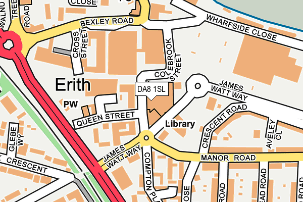
DA8 1SL is located in the Erith electoral ward, within the London borough of Bexley and the English Parliamentary constituency of Erith and Thamesmead. The Sub Integrated Care Board (ICB) Location is NHS South East London ICB - 72Q and the police force is Metropolitan Police. This postcode has been in use since October 2006.


GetTheData
Source: OS OpenMap – Local (Ordnance Survey)
Source: OS VectorMap District (Ordnance Survey)
Licence: Open Government Licence (requires attribution)
| Easting | 551573 |
| Northing | 177884 |
| Latitude | 51.479610 |
| Longitude | 0.181364 |
GetTheData
Source: Open Postcode Geo
Licence: Open Government Licence
| Country | England |
| Postcode District | DA8 |
➜ See where DA8 is on a map ➜ Where is Erith? | |
GetTheData
Source: Land Registry Price Paid Data
Licence: Open Government Licence
Elevation or altitude of DA8 1SL as distance above sea level:
| Metres | Feet | |
|---|---|---|
| Elevation | 10m | 33ft |
Elevation is measured from the approximate centre of the postcode, to the nearest point on an OS contour line from OS Terrain 50, which has contour spacing of ten vertical metres.
➜ How high above sea level am I? Find the elevation of your current position using your device's GPS.
GetTheData
Source: Open Postcode Elevation
Licence: Open Government Licence
| Ward | Erith |
| Constituency | Erith And Thamesmead |
GetTheData
Source: ONS Postcode Database
Licence: Open Government Licence
| Erith Health Centre (Erith High Street) | Erith | 25m |
| Colebrook Street | Erith | 74m |
| James Watt Way | Erith | 120m |
| Compton Place (Manor Road) | Erith | 142m |
| Erith Town Centre Riverside (Bexley Road) | Erith | 149m |
| Erith Station | 0.5km |
| Slade Green Station | 1.5km |
| Barnehurst Station | 2.2km |
GetTheData
Source: NaPTAN
Licence: Open Government Licence
GetTheData
Source: ONS Postcode Database
Licence: Open Government Licence


➜ Get more ratings from the Food Standards Agency
GetTheData
Source: Food Standards Agency
Licence: FSA terms & conditions
| Last Collection | |||
|---|---|---|---|
| Location | Mon-Fri | Sat | Distance |
| Lesney Park | 17:30 | 11:00 | 595m |
| Park Crescent | 17:30 | 11:00 | 654m |
| Beechfield | 17:30 | 11:00 | 656m |
GetTheData
Source: Dracos
Licence: Creative Commons Attribution-ShareAlike
The below table lists the International Territorial Level (ITL) codes (formerly Nomenclature of Territorial Units for Statistics (NUTS) codes) and Local Administrative Units (LAU) codes for DA8 1SL:
| ITL 1 Code | Name |
|---|---|
| TLI | London |
| ITL 2 Code | Name |
| TLI5 | Outer London - East and North East |
| ITL 3 Code | Name |
| TLI51 | Bexley and Greenwich |
| LAU 1 Code | Name |
| E09000004 | Bexley |
GetTheData
Source: ONS Postcode Directory
Licence: Open Government Licence
The below table lists the Census Output Area (OA), Lower Layer Super Output Area (LSOA), and Middle Layer Super Output Area (MSOA) for DA8 1SL:
| Code | Name | |
|---|---|---|
| OA | E00166767 | |
| LSOA | E01000403 | Bexley 004A |
| MSOA | E02000068 | Bexley 004 |
GetTheData
Source: ONS Postcode Directory
Licence: Open Government Licence
| DA8 1GL | Erith High Street | 46m |
| DA8 1TB | Pier Road | 83m |
| DA8 1RU | Cornelia Place | 139m |
| DA8 1TA | Pier Road | 165m |
| DA8 1SQ | James Watt Way | 172m |
| DA8 1RB | Cross Street | 173m |
| DA8 2AB | Manor Road | 181m |
| DA8 1QW | Wharfside Close | 193m |
| DA8 1SB | Saltford Close | 204m |
| DA8 2AU | Crescent Road | 212m |
GetTheData
Source: Open Postcode Geo; Land Registry Price Paid Data
Licence: Open Government Licence