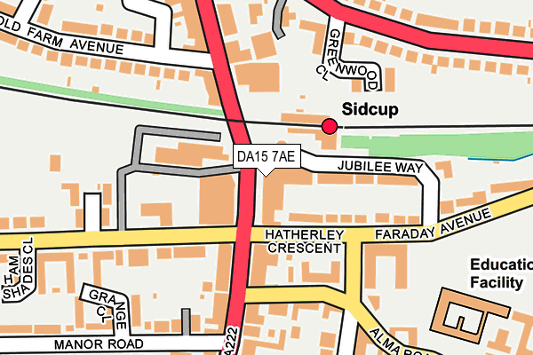
DA15 7AE is located in the Sidcup electoral ward, within the London borough of Bexley and the English Parliamentary constituency of Old Bexley and Sidcup. The Sub Integrated Care Board (ICB) Location is NHS South East London ICB - 72Q and the police force is Metropolitan Police. This postcode has been in use since December 2013.


GetTheData
Source: OS OpenMap – Local (Ordnance Survey)
Source: OS VectorMap District (Ordnance Survey)
Licence: Open Government Licence (requires attribution)
| Easting | 546285 |
| Northing | 172620 |
| Latitude | 51.433702 |
| Longitude | 0.103094 |
GetTheData
Source: Open Postcode Geo
Licence: Open Government Licence
| Country | England |
| Postcode District | DA15 |
| ➜ DA15 open data dashboard ➜ See where DA15 is on a map ➜ Where is Sidcup? | |
GetTheData
Source: Land Registry Price Paid Data
Licence: Open Government Licence
Elevation or altitude of DA15 7AE as distance above sea level:
| Metres | Feet | |
|---|---|---|
| Elevation | 40m | 131ft |
Elevation is measured from the approximate centre of the postcode, to the nearest point on an OS contour line from OS Terrain 50, which has contour spacing of ten vertical metres.
➜ How high above sea level am I? Find the elevation of your current position using your device's GPS.
GetTheData
Source: Open Postcode Elevation
Licence: Open Government Licence
| Ward | Sidcup |
| Constituency | Old Bexley And Sidcup |
GetTheData
Source: ONS Postcode Database
Licence: Open Government Licence
| December 2023 | Anti-social behaviour | On or near Parking Area | 97m |
| December 2023 | Burglary | On or near Langford Place | 396m |
| November 2023 | Anti-social behaviour | On or near Parking Area | 97m |
| ➜ Get more crime data in our Crime section | |||
GetTheData
Source: data.police.uk
Licence: Open Government Licence
| Sidcup | Sidcup | 49m |
| Hatherley Crescent Sidcup Stn | Sidcup | 99m |
| Sidcup | Sidcup | 120m |
| Sidcup | Sidcup | 124m |
| Sidcup Station Station Road | Sidcup | 133m |
| Sidcup Station | 0.1km |
| Albany Park Station | 1.6km |
| New Eltham Station | 2.3km |
GetTheData
Source: NaPTAN
Licence: Open Government Licence
GetTheData
Source: ONS Postcode Database
Licence: Open Government Licence


➜ Get more ratings from the Food Standards Agency
GetTheData
Source: Food Standards Agency
Licence: FSA terms & conditions
| Last Collection | |||
|---|---|---|---|
| Location | Mon-Fri | Sat | Distance |
| Old Farm Avenue | 17:30 | 11:30 | 509m |
| Birkbeck Road | 17:30 | 11:30 | 529m |
| Christchurch Road | 17:30 | 11:30 | 568m |
GetTheData
Source: Dracos
Licence: Creative Commons Attribution-ShareAlike
| Facility | Distance |
|---|---|
| Lamorbey Swim Centre (Closed) Station Road, Sidcup Swimming Pool, Health and Fitness Gym | 237m |
| King Georges Playing Fields (Sidcup) Longlands Road, Sidcup Grass Pitches | 271m |
| Birkbeck Primary School Alma Road, Sidcup Grass Pitches | 274m |
GetTheData
Source: Active Places
Licence: Open Government Licence
| School | Phase of Education | Distance |
|---|---|---|
| Birkbeck Primary School Alma Road, Sidcup, DA14 4ED | Primary | 274m |
| Holy Trinity Lamorbey Church of England School Burnt Oak Lane, Sidcup, DA15 9DB | Primary | 396m |
| Chislehurst and Sidcup Grammar School Hurst Road, Sidcup, DA15 9AG | Secondary | 402m |
GetTheData
Source: Edubase
Licence: Open Government Licence
The below table lists the International Territorial Level (ITL) codes (formerly Nomenclature of Territorial Units for Statistics (NUTS) codes) and Local Administrative Units (LAU) codes for DA15 7AE:
| ITL 1 Code | Name |
|---|---|
| TLI | London |
| ITL 2 Code | Name |
| TLI5 | Outer London - East and North East |
| ITL 3 Code | Name |
| TLI51 | Bexley and Greenwich |
| LAU 1 Code | Name |
| E09000004 | Bexley |
GetTheData
Source: ONS Postcode Directory
Licence: Open Government Licence
The below table lists the Census Output Area (OA), Lower Layer Super Output Area (LSOA), and Middle Layer Super Output Area (MSOA) for DA15 7AE:
| Code | Name | |
|---|---|---|
| OA | E00002272 | |
| LSOA | E01000462 | Bexley 026E |
| MSOA | E02000090 | Bexley 026 |
GetTheData
Source: ONS Postcode Directory
Licence: Open Government Licence
| DA15 7AP | Station Road | 10m |
| DA15 7AH | Station Road | 23m |
| DA15 7DB | Station Parade | 56m |
| DA15 7AJ | Station Road | 97m |
| DA15 7DE | Station Road | 117m |
| DA15 7AB | Station Road | 129m |
| DA15 7DH | Central Parade | 130m |
| DA14 4JA | Hatherley Crescent | 131m |
| DA14 4JP | Jubilee Way | 136m |
| DA14 4HN | Alma Road | 147m |
GetTheData
Source: Open Postcode Geo; Land Registry Price Paid Data
Licence: Open Government Licence