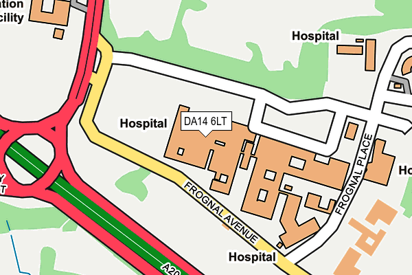
DA14 6LT is located in the Sidcup electoral ward, within the London borough of Bexley and the English Parliamentary constituency of Old Bexley and Sidcup. The Sub Integrated Care Board (ICB) Location is NHS South East London ICB - 72Q and the police force is Metropolitan Police. This postcode has been in use since August 2018.


GetTheData
Source: OS OpenMap – Local (Ordnance Survey)
Source: OS VectorMap District (Ordnance Survey)
Licence: Open Government Licence (requires attribution)
| Easting | 546234 |
| Northing | 170987 |
| Latitude | 51.419041 |
| Longitude | 0.101687 |
GetTheData
Source: Open Postcode Geo
Licence: Open Government Licence
| Country | England |
| Postcode District | DA14 |
| ➜ DA14 open data dashboard ➜ See where DA14 is on a map ➜ Where is Sidcup? | |
GetTheData
Source: Land Registry Price Paid Data
Licence: Open Government Licence
Elevation or altitude of DA14 6LT as distance above sea level:
| Metres | Feet | |
|---|---|---|
| Elevation | 60m | 197ft |
Elevation is measured from the approximate centre of the postcode, to the nearest point on an OS contour line from OS Terrain 50, which has contour spacing of ten vertical metres.
➜ How high above sea level am I? Find the elevation of your current position using your device's GPS.
GetTheData
Source: Open Postcode Elevation
Licence: Open Government Licence
| Ward | Sidcup |
| Constituency | Old Bexley And Sidcup |
GetTheData
Source: ONS Postcode Database
Licence: Open Government Licence
| June 2022 | Other theft | On or near Sidcup By-Pass Road | 213m |
| June 2022 | Violence and sexual offences | On or near Sidcup By-Pass Road | 213m |
| June 2022 | Violence and sexual offences | On or near Sidcup By-Pass Road | 213m |
| ➜ Get more crime data in our Crime section | |||
GetTheData
Source: data.police.uk
Licence: Open Government Licence
| Queen Marys Hospital A&e (Frognal Place) | Sidcup | 74m |
| Queen Mary's Hospital Frognal Avenue | Sidcup | 171m |
| Sidcup Queen Mary's Hospital (Frognal Avenue) | Sidcup | 171m |
| Sidcup Queen Mary's Hospital | Sidcup | 191m |
| Queen Mary's Hospital Chislehurst Road | Sidcup | 195m |
| Sidcup Station | 1.7km |
| Albany Park Station | 2.5km |
| St Mary Cray Station | 2.7km |
GetTheData
Source: NaPTAN
Licence: Open Government Licence
| Percentage of properties with Next Generation Access | 0.0% |
| Percentage of properties with Superfast Broadband | 0.0% |
| Percentage of properties with Ultrafast Broadband | 0.0% |
| Percentage of properties with Full Fibre Broadband | 0.0% |
Superfast Broadband is between 30Mbps and 300Mbps
Ultrafast Broadband is > 300Mbps
| Percentage of properties unable to receive 2Mbps | 0.0% |
| Percentage of properties unable to receive 5Mbps | 0.0% |
| Percentage of properties unable to receive 10Mbps | 0.0% |
| Percentage of properties unable to receive 30Mbps | 100.0% |
GetTheData
Source: Ofcom
Licence: Ofcom Terms of Use (requires attribution)
GetTheData
Source: ONS Postcode Database
Licence: Open Government Licence


➜ Get more ratings from the Food Standards Agency
GetTheData
Source: Food Standards Agency
Licence: FSA terms & conditions
| Last Collection | |||
|---|---|---|---|
| Location | Mon-Fri | Sat | Distance |
| Tyron Way | 17:30 | 11:30 | 769m |
| The Avenue (22) | 17:45 | 12:00 | 780m |
| Grovelands Road (80) | 18:00 | 12:00 | 887m |
GetTheData
Source: Dracos
Licence: Creative Commons Attribution-ShareAlike
| Facility | Distance |
|---|---|
| Christ The King St Marys Sixth Form College Chislehurst Road, Sidcup Health and Fitness Gym, Grass Pitches, Sports Hall | 283m |
| Sidcup Place The Green, Sidcup Outdoor Tennis Courts | 309m |
| Sidcup Recreation Club Church Avenue, Sidcup Outdoor Tennis Courts | 479m |
GetTheData
Source: Active Places
Licence: Open Government Licence
| School | Phase of Education | Distance |
|---|---|---|
| Orchard Primary School Oxford Road, Sidcup, DA14 6LW | Primary | 667m |
| Chislehurst School for Girls Beaverwood Road, Perry Street, Chislehurst, BR7 6HE | Secondary | 869m |
| Merton Court School 38 Knoll Road, Sidcup, DA14 4QU | Not applicable | 936m |
GetTheData
Source: Edubase
Licence: Open Government Licence
The below table lists the International Territorial Level (ITL) codes (formerly Nomenclature of Territorial Units for Statistics (NUTS) codes) and Local Administrative Units (LAU) codes for DA14 6LT:
| ITL 1 Code | Name |
|---|---|
| TLI | London |
| ITL 2 Code | Name |
| TLI5 | Outer London - East and North East |
| ITL 3 Code | Name |
| TLI51 | Bexley and Greenwich |
| LAU 1 Code | Name |
| E09000004 | Bexley |
GetTheData
Source: ONS Postcode Directory
Licence: Open Government Licence
The below table lists the Census Output Area (OA), Lower Layer Super Output Area (LSOA), and Middle Layer Super Output Area (MSOA) for DA14 6LT:
| Code | Name | |
|---|---|---|
| OA | E00002088 | |
| LSOA | E01000428 | Bexley 027D |
| MSOA | E02000091 | Bexley 027 |
GetTheData
Source: ONS Postcode Directory
Licence: Open Government Licence
| DA14 6LF | Frognal Avenue | 113m |
| DA14 6LU | Sidcup By Pass | 322m |
| DA14 6TS | Chislehurst Road | 349m |
| DA14 6BE | Chislehurst Road | 362m |
| DA14 6BD | Chislehurst Road | 382m |
| DA14 6BG | Chislehurst Road | 411m |
| DA14 6LS | Frognal Place | 417m |
| BR7 6HD | Leas Green | 428m |
| DA14 6BQ | Chislehurst Road | 434m |
| DA14 6BH | Chislehurst Road | 453m |
GetTheData
Source: Open Postcode Geo; Land Registry Price Paid Data
Licence: Open Government Licence