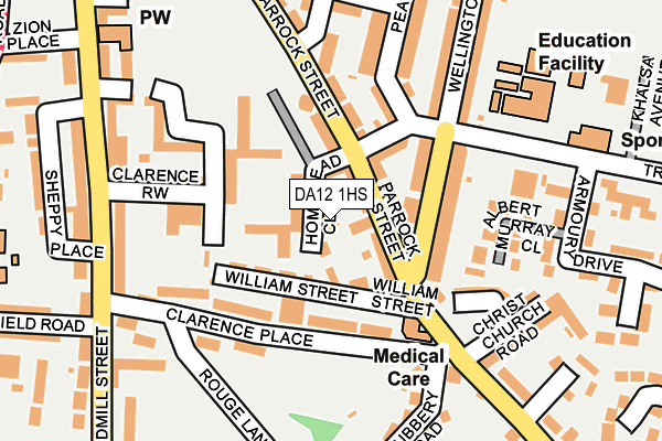
DA12 1HS is located in the Town electoral ward, within the local authority district of Gravesham and the English Parliamentary constituency of Gravesham. The Sub Integrated Care Board (ICB) Location is NHS Kent and Medway ICB - 91Q and the police force is Kent. This postcode has been in use since October 2005.


GetTheData
Source: OS OpenMap – Local (Ordnance Survey)
Source: OS VectorMap District (Ordnance Survey)
Licence: Open Government Licence (requires attribution)
| Easting | 564967 |
| Northing | 173602 |
| Latitude | 51.437397 |
| Longitude | 0.372051 |
GetTheData
Source: Open Postcode Geo
Licence: Open Government Licence
| Country | England |
| Postcode District | DA12 |
| ➜ DA12 open data dashboard ➜ See where DA12 is on a map ➜ Where is Gravesend? | |
GetTheData
Source: Land Registry Price Paid Data
Licence: Open Government Licence
Elevation or altitude of DA12 1HS as distance above sea level:
| Metres | Feet | |
|---|---|---|
| Elevation | 30m | 98ft |
Elevation is measured from the approximate centre of the postcode, to the nearest point on an OS contour line from OS Terrain 50, which has contour spacing of ten vertical metres.
➜ How high above sea level am I? Find the elevation of your current position using your device's GPS.
GetTheData
Source: Open Postcode Elevation
Licence: Open Government Licence
| Ward | Town |
| Constituency | Gravesham |
GetTheData
Source: ONS Postcode Database
Licence: Open Government Licence
| January 2024 | Violence and sexual offences | On or near Cumberland Avenue | 432m |
| November 2023 | Drugs | On or near Cumberland Avenue | 432m |
| October 2023 | Vehicle crime | On or near Bronte View | 334m |
| ➜ Get more crime data in our Crime section | |||
GetTheData
Source: data.police.uk
Licence: Open Government Licence
| William Street (Parrock Street) | Gravesend | 66m |
| William Street (Parrock Road) | Gravesend | 131m |
| The Grove (Parrock Street) | Gravesend | 186m |
| Clarence Row (Windmill Street) | Gravesend | 203m |
| Clarence Row (Windmill Street) | Gravesend | 215m |
| Gravesend Station | 0.6km |
| Tilbury Town Station | 3km |
| Northfleet Station | 3.4km |
GetTheData
Source: NaPTAN
Licence: Open Government Licence
| Percentage of properties with Next Generation Access | 100.0% |
| Percentage of properties with Superfast Broadband | 100.0% |
| Percentage of properties with Ultrafast Broadband | 100.0% |
| Percentage of properties with Full Fibre Broadband | 50.0% |
Superfast Broadband is between 30Mbps and 300Mbps
Ultrafast Broadband is > 300Mbps
| Percentage of properties unable to receive 2Mbps | 0.0% |
| Percentage of properties unable to receive 5Mbps | 0.0% |
| Percentage of properties unable to receive 10Mbps | 0.0% |
| Percentage of properties unable to receive 30Mbps | 0.0% |
GetTheData
Source: Ofcom
Licence: Ofcom Terms of Use (requires attribution)
GetTheData
Source: ONS Postcode Database
Licence: Open Government Licence


➜ Get more ratings from the Food Standards Agency
GetTheData
Source: Food Standards Agency
Licence: FSA terms & conditions
| Last Collection | |||
|---|---|---|---|
| Location | Mon-Fri | Sat | Distance |
| Homemead | 17:30 | 11:15 | 64m |
| Clarence Place | 17:30 | 11:15 | 155m |
| Wrotham Road Post Office | 18:30 | 12:00 | 336m |
GetTheData
Source: Dracos
Licence: Creative Commons Attribution-ShareAlike
| Facility | Distance |
|---|---|
| Windmill Gardens Clarence Place, Gravesend Outdoor Tennis Courts | 131m |
| Holy Trinity Primary School Trinity Road, Gravesend Grass Pitches | 217m |
| Guru Nanak Sports Ground Guru Nanak Marg, Gravesend Sports Hall, Grass Pitches, Health and Fitness Gym, Studio | 413m |
GetTheData
Source: Active Places
Licence: Open Government Licence
| School | Phase of Education | Distance |
|---|---|---|
| Holy Trinity Church of England Primary School Trinity Road, Gravesend, DA12 1LU | Primary | 218m |
| Wrotham Road Primary School Wrotham Road, Gravesend, DA11 0QF | Primary | 342m |
| Pier View Academy 42-44 Harmer Street, Gravesend, DA12 2AX | Not applicable | 519m |
GetTheData
Source: Edubase
Licence: Open Government Licence
The below table lists the International Territorial Level (ITL) codes (formerly Nomenclature of Territorial Units for Statistics (NUTS) codes) and Local Administrative Units (LAU) codes for DA12 1HS:
| ITL 1 Code | Name |
|---|---|
| TLJ | South East (England) |
| ITL 2 Code | Name |
| TLJ4 | Kent |
| ITL 3 Code | Name |
| TLJ43 | Kent Thames Gateway |
| LAU 1 Code | Name |
| E07000109 | Gravesham |
GetTheData
Source: ONS Postcode Directory
Licence: Open Government Licence
The below table lists the Census Output Area (OA), Lower Layer Super Output Area (LSOA), and Middle Layer Super Output Area (MSOA) for DA12 1HS:
| Code | Name | |
|---|---|---|
| OA | E00123172 | |
| LSOA | E01024257 | Gravesham 002A |
| MSOA | E02005056 | Gravesham 002 |
GetTheData
Source: ONS Postcode Directory
Licence: Open Government Licence
| DA12 1HF | Parrock Street | 36m |
| DA12 1HQ | Homemead Close | 57m |
| DA12 1HD | William Street | 61m |
| DA12 1EX | Parrock Street | 62m |
| DA12 1HB | Waterloo Street | 88m |
| DA12 1EZ | Parrock Street | 100m |
| DA12 1LD | Clarence Place | 104m |
| DA12 1JQ | Wellington Street | 105m |
| DA12 1HE | Parrock Street | 119m |
| DA12 1HN | Clarence Row | 120m |
GetTheData
Source: Open Postcode Geo; Land Registry Price Paid Data
Licence: Open Government Licence