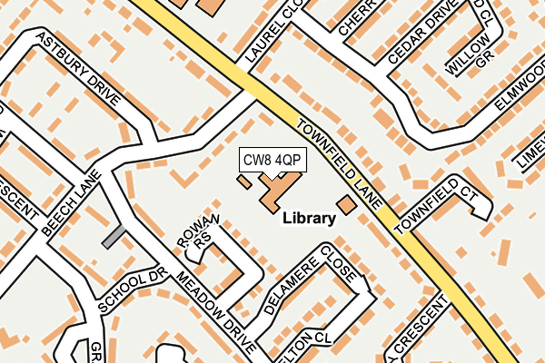
CW8 4QP is located in the Marbury electoral ward, within the unitary authority of Cheshire West and Chester and the English Parliamentary constituency of Tatton. The Sub Integrated Care Board (ICB) Location is NHS Cheshire and Merseyside ICB - 27D and the police force is Cheshire. This postcode has been in use since August 1992.


GetTheData
Source: OS OpenMap – Local (Ordnance Survey)
Source: OS VectorMap District (Ordnance Survey)
Licence: Open Government Licence (requires attribution)
| Easting | 363326 |
| Northing | 375489 |
| Latitude | 53.275107 |
| Longitude | -2.551421 |
GetTheData
Source: Open Postcode Geo
Licence: Open Government Licence
| Country | England |
| Postcode District | CW8 |
| ➜ CW8 open data dashboard ➜ See where CW8 is on a map ➜ Where is Barnton? | |
GetTheData
Source: Land Registry Price Paid Data
Licence: Open Government Licence
Elevation or altitude of CW8 4QP as distance above sea level:
| Metres | Feet | |
|---|---|---|
| Elevation | 50m | 164ft |
Elevation is measured from the approximate centre of the postcode, to the nearest point on an OS contour line from OS Terrain 50, which has contour spacing of ten vertical metres.
➜ How high above sea level am I? Find the elevation of your current position using your device's GPS.
GetTheData
Source: Open Postcode Elevation
Licence: Open Government Licence
| Ward | Marbury |
| Constituency | Tatton |
GetTheData
Source: ONS Postcode Database
Licence: Open Government Licence
| November 2023 | Violence and sexual offences | On or near Hindley Crescent | 283m |
| October 2023 | Anti-social behaviour | On or near Hindley Crescent | 283m |
| September 2023 | Criminal damage and arson | On or near Hindley Crescent | 283m |
| ➜ Get more crime data in our Crime section | |||
GetTheData
Source: data.police.uk
Licence: Open Government Licence
| Beech Lane (Townfield Lane) | Barnton | 78m |
| Library (Townfield Lane) | Barnton | 96m |
| School Drive (Meadow Drive) | Barnton | 139m |
| School Drive (Meadow Drive) | Barnton | 164m |
| Beech Lane (Alamein Road) | Barnton | 225m |
| Greenbank Station | 2.9km |
| Acton Bridge Station | 3.6km |
| Hartford Station | 3.7km |
GetTheData
Source: NaPTAN
Licence: Open Government Licence
GetTheData
Source: ONS Postcode Database
Licence: Open Government Licence


➜ Get more ratings from the Food Standards Agency
GetTheData
Source: Food Standards Agency
Licence: FSA terms & conditions
| Last Collection | |||
|---|---|---|---|
| Location | Mon-Fri | Sat | Distance |
| Broomfield Lane | 17:30 | 11:30 | 463m |
| Barnton So | 17:30 | 11:30 | 546m |
| Barrymore Road | 17:30 | 11:30 | 1,760m |
GetTheData
Source: Dracos
Licence: Creative Commons Attribution-ShareAlike
| Facility | Distance |
|---|---|
| Barnton Community Nursery And Primary School Townfield Lane, Barnton, Northwich Grass Pitches | 238m |
| Barnton Fc (Offside Trust Stadium) Townfield Lane, Barnton, Northwich Grass Pitches | 287m |
| Barnton Cricket Club Townfield Lane, Barnton, Northwich Grass Pitches, Squash Courts | 380m |
GetTheData
Source: Active Places
Licence: Open Government Licence
| School | Phase of Education | Distance |
|---|---|---|
| Rosebank School Townfield Lane, Barnton, Northwich, CW8 4QP | Not applicable | 5m |
| Barnton Community Nursery and Primary School Townfield Lane, Barnton, Northwich, CW8 4QL | Primary | 228m |
| Little Leigh Primary School Shutley Lane, Little Leigh, Northwich, CW8 4RN | Primary | 1.6km |
GetTheData
Source: Edubase
Licence: Open Government Licence
The below table lists the International Territorial Level (ITL) codes (formerly Nomenclature of Territorial Units for Statistics (NUTS) codes) and Local Administrative Units (LAU) codes for CW8 4QP:
| ITL 1 Code | Name |
|---|---|
| TLD | North West (England) |
| ITL 2 Code | Name |
| TLD6 | Cheshire |
| ITL 3 Code | Name |
| TLD63 | Cheshire West and Chester |
| LAU 1 Code | Name |
| E06000050 | Cheshire West and Chester |
GetTheData
Source: ONS Postcode Directory
Licence: Open Government Licence
The below table lists the Census Output Area (OA), Lower Layer Super Output Area (LSOA), and Middle Layer Super Output Area (MSOA) for CW8 4QP:
| Code | Name | |
|---|---|---|
| OA | E00094248 | |
| LSOA | E01018672 | Cheshire West and Chester 012B |
| MSOA | E02003876 | Cheshire West and Chester 012 |
GetTheData
Source: ONS Postcode Directory
Licence: Open Government Licence
| CW8 4PW | Beech Lane | 68m |
| CW8 4NZ | Rowan Rise | 100m |
| CW8 4QL | Townfield Lane | 107m |
| CW8 4SE | Delamere Close | 127m |
| CW8 4NB | Elmwood Road | 147m |
| CW8 4PL | Meadow Drive | 153m |
| CW8 4PN | Beech Lane | 171m |
| CW8 4LJ | Townfield Lane | 174m |
| CW8 4PH | Meadow Drive | 184m |
| CW8 4PJ | School Drive | 193m |
GetTheData
Source: Open Postcode Geo; Land Registry Price Paid Data
Licence: Open Government Licence