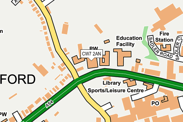
CW7 2AN is located in the Winsford Over & Verdin electoral ward, within the unitary authority of Cheshire West and Chester and the English Parliamentary constituency of Eddisbury. The Sub Integrated Care Board (ICB) Location is NHS Cheshire and Merseyside ICB - 27D and the police force is Cheshire. This postcode has been in use since February 1990.


GetTheData
Source: OS OpenMap – Local (Ordnance Survey)
Source: OS VectorMap District (Ordnance Survey)
Licence: Open Government Licence (requires attribution)
| Easting | 364643 |
| Northing | 366362 |
| Latitude | 53.193159 |
| Longitude | -2.530656 |
GetTheData
Source: Open Postcode Geo
Licence: Open Government Licence
| Country | England |
| Postcode District | CW7 |
| ➜ CW7 open data dashboard ➜ See where CW7 is on a map ➜ Where is Winsford? | |
GetTheData
Source: Land Registry Price Paid Data
Licence: Open Government Licence
Elevation or altitude of CW7 2AN as distance above sea level:
| Metres | Feet | |
|---|---|---|
| Elevation | 40m | 131ft |
Elevation is measured from the approximate centre of the postcode, to the nearest point on an OS contour line from OS Terrain 50, which has contour spacing of ten vertical metres.
➜ How high above sea level am I? Find the elevation of your current position using your device's GPS.
GetTheData
Source: Open Postcode Elevation
Licence: Open Government Licence
| Ward | Winsford Over & Verdin |
| Constituency | Eddisbury |
GetTheData
Source: ONS Postcode Database
Licence: Open Government Licence
| January 2024 | Other theft | On or near High Street | 159m |
| January 2024 | Anti-social behaviour | On or near Parking Area | 181m |
| December 2023 | Violence and sexual offences | On or near High Street | 159m |
| ➜ Get more crime data in our Crime section | |||
GetTheData
Source: data.police.uk
Licence: Open Government Licence
| Guildhall (High Street) | Winsford | 27m |
| Library (High Street) | Winsford | 108m |
| Asda (Dene Drive) | Winsford | 186m |
| The Queens (Dene Drive) | Winsford | 204m |
| Well Street (High Street) | Winsford | 337m |
| Winsford Station | 2.4km |
GetTheData
Source: NaPTAN
Licence: Open Government Licence
GetTheData
Source: ONS Postcode Database
Licence: Open Government Licence


➜ Get more ratings from the Food Standards Agency
GetTheData
Source: Food Standards Agency
Licence: FSA terms & conditions
| Last Collection | |||
|---|---|---|---|
| Location | Mon-Fri | Sat | Distance |
| Queens Hotel | 17:30 | 11:30 | 169m |
| Over So | 17:00 | 11:30 | 739m |
| St Georges Road | 17:30 | 11:30 | 849m |
GetTheData
Source: Dracos
Licence: Creative Commons Attribution-ShareAlike
| Facility | Distance |
|---|---|
| Winsford High Street Community Primary School High Street, Winsford Grass Pitches | 93m |
| The Verdin Exchange Playing Field Grange Lane, Winsford Grass Pitches | 230m |
| Dw Fitness First (Winsford) (Closed) Jubilee Way, Winsford Health and Fitness Gym, Studio | 313m |
GetTheData
Source: Active Places
Licence: Open Government Licence
| School | Phase of Education | Distance |
|---|---|---|
| Winsford High Street Community Primary School High Street, Winsford, CW7 2AU | Primary | 92m |
| The Winsford Academy Grange Lane, Winsford, CW7 2BT | Secondary | 411m |
| Grange Community Nursery and Primary School Brindley Avenue, Grange Community Nursery and Primary School, Winsford, CW7 2EG | Primary | 664m |
GetTheData
Source: Edubase
Licence: Open Government Licence
The below table lists the International Territorial Level (ITL) codes (formerly Nomenclature of Territorial Units for Statistics (NUTS) codes) and Local Administrative Units (LAU) codes for CW7 2AN:
| ITL 1 Code | Name |
|---|---|
| TLD | North West (England) |
| ITL 2 Code | Name |
| TLD6 | Cheshire |
| ITL 3 Code | Name |
| TLD63 | Cheshire West and Chester |
| LAU 1 Code | Name |
| E06000050 | Cheshire West and Chester |
GetTheData
Source: ONS Postcode Directory
Licence: Open Government Licence
The below table lists the Census Output Area (OA), Lower Layer Super Output Area (LSOA), and Middle Layer Super Output Area (MSOA) for CW7 2AN:
| Code | Name | |
|---|---|---|
| OA | E00094619 | |
| LSOA | E01018746 | Cheshire West and Chester 038C |
| MSOA | E02003888 | Cheshire West and Chester 038 |
GetTheData
Source: ONS Postcode Directory
Licence: Open Government Licence
| CW7 2BP | Grange Lane | 159m |
| CW7 2DP | High Street | 166m |
| CW7 2AU | High Street | 170m |
| CW7 1HG | Dean Street | 264m |
| CW7 2DF | Roehurst Lane | 294m |
| CW7 2DS | High Street | 297m |
| CW7 2BU | Joyce Avenue | 306m |
| CW7 2DE | Haweswater Drive | 316m |
| CW7 1HU | The Mews | 354m |
| CW7 1HQ | John Street | 354m |
GetTheData
Source: Open Postcode Geo; Land Registry Price Paid Data
Licence: Open Government Licence