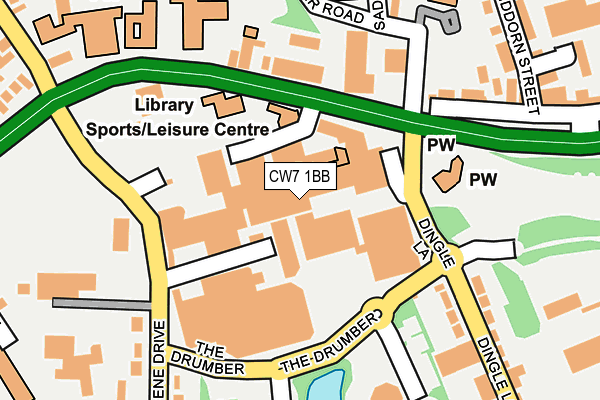
CW7 1BB is located in the Winsford Dene electoral ward, within the unitary authority of Cheshire West and Chester and the English Parliamentary constituency of Eddisbury. The Sub Integrated Care Board (ICB) Location is NHS Cheshire and Merseyside ICB - 27D and the police force is Cheshire. This postcode has been in use since January 1980.


GetTheData
Source: OS OpenMap – Local (Ordnance Survey)
Source: OS VectorMap District (Ordnance Survey)
Licence: Open Government Licence (requires attribution)
| Easting | 364845 |
| Northing | 366195 |
| Latitude | 53.191671 |
| Longitude | -2.527615 |
GetTheData
Source: Open Postcode Geo
Licence: Open Government Licence
| Country | England |
| Postcode District | CW7 |
| ➜ CW7 open data dashboard ➜ See where CW7 is on a map ➜ Where is Winsford? | |
GetTheData
Source: Land Registry Price Paid Data
Licence: Open Government Licence
Elevation or altitude of CW7 1BB as distance above sea level:
| Metres | Feet | |
|---|---|---|
| Elevation | 40m | 131ft |
Elevation is measured from the approximate centre of the postcode, to the nearest point on an OS contour line from OS Terrain 50, which has contour spacing of ten vertical metres.
➜ How high above sea level am I? Find the elevation of your current position using your device's GPS.
GetTheData
Source: Open Postcode Elevation
Licence: Open Government Licence
| Ward | Winsford Dene |
| Constituency | Eddisbury |
GetTheData
Source: ONS Postcode Database
Licence: Open Government Licence
| January 2024 | Other theft | On or near High Street | 124m |
| January 2024 | Anti-social behaviour | On or near Parking Area | 245m |
| December 2023 | Violence and sexual offences | On or near High Street | 124m |
| ➜ Get more crime data in our Crime section | |||
GetTheData
Source: data.police.uk
Licence: Open Government Licence
| The Queens (Dene Drive) | Winsford | 139m |
| Asda (The Drumber) | Winsford | 146m |
| Library (High Street) | Winsford | 156m |
| Asda (Dene Drive) | Winsford | 169m |
| Siddon Street (High Street) | Winsford | 221m |
| Winsford Station | 2.2km |
GetTheData
Source: NaPTAN
Licence: Open Government Licence
GetTheData
Source: ONS Postcode Database
Licence: Open Government Licence


➜ Get more ratings from the Food Standards Agency
GetTheData
Source: Food Standards Agency
Licence: FSA terms & conditions
| Last Collection | |||
|---|---|---|---|
| Location | Mon-Fri | Sat | Distance |
| Queens Hotel | 17:30 | 11:30 | 149m |
| St Georges Road | 17:30 | 11:30 | 843m |
| Over So | 17:00 | 11:30 | 863m |
GetTheData
Source: Dracos
Licence: Creative Commons Attribution-ShareAlike
| Facility | Distance |
|---|---|
| Dw Fitness First (Winsford) (Closed) Jubilee Way, Winsford Health and Fitness Gym, Studio | 51m |
| Winsford High Street Community Primary School High Street, Winsford Grass Pitches | 207m |
| Winsford Sports Complex (Closed) The Drumber, Winsford Swimming Pool, Health and Fitness Gym, Squash Courts | 230m |
GetTheData
Source: Active Places
Licence: Open Government Licence
| School | Phase of Education | Distance |
|---|---|---|
| Winsford High Street Community Primary School High Street, Winsford, CW7 2AU | Primary | 207m |
| St. Chad's Church of England Primary and Nursery School Gladstone Street, Winsford, CW7 4AT | Primary | 661m |
| The Winsford Academy Grange Lane, Winsford, CW7 2BT | Secondary | 672m |
GetTheData
Source: Edubase
Licence: Open Government Licence
The below table lists the International Territorial Level (ITL) codes (formerly Nomenclature of Territorial Units for Statistics (NUTS) codes) and Local Administrative Units (LAU) codes for CW7 1BB:
| ITL 1 Code | Name |
|---|---|
| TLD | North West (England) |
| ITL 2 Code | Name |
| TLD6 | Cheshire |
| ITL 3 Code | Name |
| TLD63 | Cheshire West and Chester |
| LAU 1 Code | Name |
| E06000050 | Cheshire West and Chester |
GetTheData
Source: ONS Postcode Directory
Licence: Open Government Licence
The below table lists the Census Output Area (OA), Lower Layer Super Output Area (LSOA), and Middle Layer Super Output Area (MSOA) for CW7 1BB:
| Code | Name | |
|---|---|---|
| OA | E00094557 | |
| LSOA | E01018732 | Cheshire West and Chester 038A |
| MSOA | E02003888 | Cheshire West and Chester 038 |
GetTheData
Source: ONS Postcode Directory
Licence: Open Government Licence
| CW7 2AU | High Street | 142m |
| CW7 2AY | High Street | 226m |
| CW7 1AA | Dingle Lane | 268m |
| CW7 1AB | Dingle Lane | 272m |
| CW7 2BA | Siddorn Street | 286m |
| CW7 1BP | Dene Drive | 287m |
| CW7 1BL | Dene Drive | 299m |
| CW7 2GP | Pimlott Drive | 315m |
| CW7 2AP | High Street | 334m |
| CW7 1HG | Dean Street | 336m |
GetTheData
Source: Open Postcode Geo; Land Registry Price Paid Data
Licence: Open Government Licence