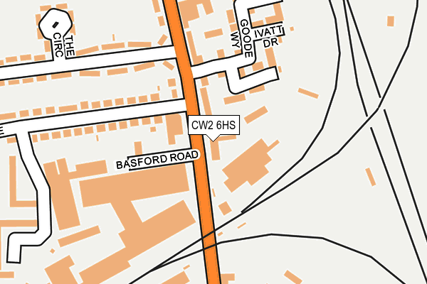
CW2 6HS is located in the Crewe South electoral ward, within the unitary authority of Cheshire East and the English Parliamentary constituency of Crewe and Nantwich. The Sub Integrated Care Board (ICB) Location is NHS Cheshire and Merseyside ICB - 27D and the police force is Cheshire. This postcode has been in use since September 1991.


GetTheData
Source: OS OpenMap – Local (Ordnance Survey)
Source: OS VectorMap District (Ordnance Survey)
Licence: Open Government Licence (requires attribution)
| Easting | 370982 |
| Northing | 353933 |
| Latitude | 53.081824 |
| Longitude | -2.434652 |
GetTheData
Source: Open Postcode Geo
Licence: Open Government Licence
| Country | England |
| Postcode District | CW2 |
| ➜ CW2 open data dashboard ➜ See where CW2 is on a map ➜ Where is Crewe? | |
GetTheData
Source: Land Registry Price Paid Data
Licence: Open Government Licence
Elevation or altitude of CW2 6HS as distance above sea level:
| Metres | Feet | |
|---|---|---|
| Elevation | 50m | 164ft |
Elevation is measured from the approximate centre of the postcode, to the nearest point on an OS contour line from OS Terrain 50, which has contour spacing of ten vertical metres.
➜ How high above sea level am I? Find the elevation of your current position using your device's GPS.
GetTheData
Source: Open Postcode Elevation
Licence: Open Government Licence
| Ward | Crewe South |
| Constituency | Crewe And Nantwich |
GetTheData
Source: ONS Postcode Database
Licence: Open Government Licence
| December 2023 | Criminal damage and arson | On or near Snape Road | 446m |
| November 2023 | Anti-social behaviour | On or near Snape Road | 446m |
| November 2023 | Public order | On or near Snape Road | 446m |
| ➜ Get more crime data in our Crime section | |||
GetTheData
Source: data.police.uk
Licence: Open Government Licence
| Gresty Road (Davenport Avenue) | Crewe | 102m |
| Gresty Road (Davenport Avenue) | Crewe | 111m |
| Ymca (Gresty Road) | Crewe | 137m |
| Ymca (Gresty Road) | Crewe | 161m |
| Centrac (Crewe Road) | Crewe | 341m |
| Crewe Station | 0.9km |
GetTheData
Source: NaPTAN
Licence: Open Government Licence
GetTheData
Source: ONS Postcode Database
Licence: Open Government Licence


➜ Get more ratings from the Food Standards Agency
GetTheData
Source: Food Standards Agency
Licence: FSA terms & conditions
| Last Collection | |||
|---|---|---|---|
| Location | Mon-Fri | Sat | Distance |
| Claughton Avenue | 17:30 | 12:30 | 136m |
| Davenport Avenue | 17:30 | 12:30 | 490m |
| Gresty Road | 17:00 | 13:00 | 545m |
GetTheData
Source: Dracos
Licence: Creative Commons Attribution-ShareAlike
| Facility | Distance |
|---|---|
| Foyer@189 (Crewe Ymca) Gresty Road, Crewe Health and Fitness Gym, Sports Hall, Studio | 189m |
| Crewe Alexandra (Alexandra Stadium) Gresty Road, Crewe Grass Pitches | 686m |
| Brookhouse Playing Field (Closed) Brookhouse Drive, Crewe Grass Pitches | 932m |
GetTheData
Source: Active Places
Licence: Open Government Licence
| School | Phase of Education | Distance |
|---|---|---|
| Safe Opportunities Unit G4, Scope House, Weston Road, Crewe, CW1 6DD | Not applicable | 669m |
| Pebble Brook Primary School Balmoral Avenue, Crewe, CW2 6PL | Primary | 933m |
| Westminster Nursery School Nelson Street, Crewe, CW2 7LJ | Nursery | 996m |
GetTheData
Source: Edubase
Licence: Open Government Licence
The below table lists the International Territorial Level (ITL) codes (formerly Nomenclature of Territorial Units for Statistics (NUTS) codes) and Local Administrative Units (LAU) codes for CW2 6HS:
| ITL 1 Code | Name |
|---|---|
| TLD | North West (England) |
| ITL 2 Code | Name |
| TLD6 | Cheshire |
| ITL 3 Code | Name |
| TLD62 | Cheshire East |
| LAU 1 Code | Name |
| E06000049 | Cheshire East |
GetTheData
Source: ONS Postcode Directory
Licence: Open Government Licence
The below table lists the Census Output Area (OA), Lower Layer Super Output Area (LSOA), and Middle Layer Super Output Area (MSOA) for CW2 6HS:
| Code | Name | |
|---|---|---|
| OA | E00174391 | |
| LSOA | E01018445 | Cheshire East 045A |
| MSOA | E02003834 | Cheshire East 045 |
GetTheData
Source: ONS Postcode Directory
Licence: Open Government Licence
| CW2 6EL | Gresty Road | 76m |
| CW2 6BQ | Worsdell Close | 101m |
| CW2 6EN | Gresty Road | 106m |
| CW2 6BN | Fowler Close | 155m |
| CW2 6AY | Goode Way | 157m |
| CW2 6LG | Davenport Avenue | 179m |
| CW2 6BF | Ivatt Drive | 191m |
| CW2 6ET | Claughton Avenue | 208m |
| CW2 6EJ | Gresty Road | 268m |
| CW2 6LH | Howbeck Walk | 288m |
GetTheData
Source: Open Postcode Geo; Land Registry Price Paid Data
Licence: Open Government Licence