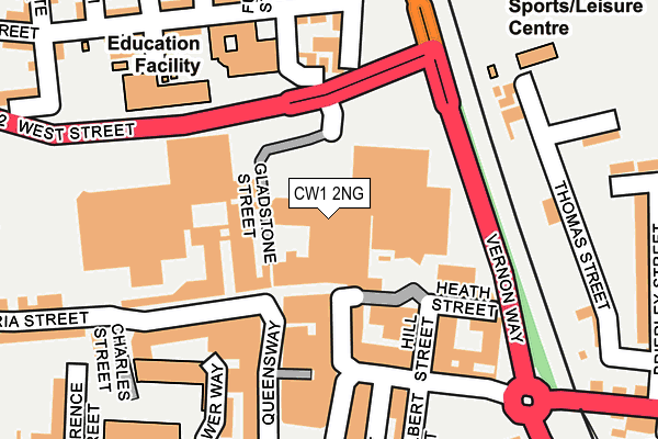
CW1 2NG is located in the Crewe Central electoral ward, within the unitary authority of Cheshire East and the English Parliamentary constituency of Crewe and Nantwich. The Sub Integrated Care Board (ICB) Location is NHS Cheshire and Merseyside ICB - 27D and the police force is Cheshire. This postcode has been in use since October 1987.


GetTheData
Source: OS OpenMap – Local (Ordnance Survey)
Source: OS VectorMap District (Ordnance Survey)
Licence: Open Government Licence (requires attribution)
| Easting | 370559 |
| Northing | 355917 |
| Latitude | 53.099650 |
| Longitude | -2.441150 |
GetTheData
Source: Open Postcode Geo
Licence: Open Government Licence
| Country | England |
| Postcode District | CW1 |
| ➜ CW1 open data dashboard ➜ See where CW1 is on a map ➜ Where is Crewe? | |
GetTheData
Source: Land Registry Price Paid Data
Licence: Open Government Licence
Elevation or altitude of CW1 2NG as distance above sea level:
| Metres | Feet | |
|---|---|---|
| Elevation | 50m | 164ft |
Elevation is measured from the approximate centre of the postcode, to the nearest point on an OS contour line from OS Terrain 50, which has contour spacing of ten vertical metres.
➜ How high above sea level am I? Find the elevation of your current position using your device's GPS.
GetTheData
Source: Open Postcode Elevation
Licence: Open Government Licence
| Ward | Crewe Central |
| Constituency | Crewe And Nantwich |
GetTheData
Source: ONS Postcode Database
Licence: Open Government Licence
| January 2024 | Anti-social behaviour | On or near Parking Area | 209m |
| January 2024 | Anti-social behaviour | On or near Parking Area | 209m |
| January 2024 | Burglary | On or near Parking Area | 209m |
| ➜ Get more crime data in our Crime section | |||
GetTheData
Source: data.police.uk
Licence: Open Government Licence
| Market (Vernon Way) | Crewe | 131m |
| Library (Prince Albert Street) | Crewe | 190m |
| Library (Prince Albert Street) | Crewe | 242m |
| The Terrace (Market Street) | Crewe | 351m |
| Hightown (Victoria Street) | Crewe | 358m |
| Crewe Station | 1.2km |
GetTheData
Source: NaPTAN
Licence: Open Government Licence
| Median download speed | 14.2Mbps |
| Average download speed | 21.6Mbps |
| Maximum download speed | 80.00Mbps |
| Median upload speed | 0.9Mbps |
| Average upload speed | 3.7Mbps |
| Maximum upload speed | 20.00Mbps |
GetTheData
Source: Ofcom
Licence: Ofcom Terms of Use (requires attribution)
GetTheData
Source: ONS Postcode Database
Licence: Open Government Licence


➜ Get more ratings from the Food Standards Agency
GetTheData
Source: Food Standards Agency
Licence: FSA terms & conditions
| Last Collection | |||
|---|---|---|---|
| Location | Mon-Fri | Sat | Distance |
| Bus Station | 17:25 | 12:30 | 189m |
| Earle Street | 17:30 | 13:00 | 400m |
| Ford Lane | 17:30 | 12:00 | 543m |
GetTheData
Source: Dracos
Licence: Creative Commons Attribution-ShareAlike
| Facility | Distance |
|---|---|
| Victoria Community Centre (Closed) West Street, Crewe Sports Hall, Health and Fitness Gym, Studio | 155m |
| Cumberland Arena The Wharf, Thomas Street, Crewe Athletics, Artificial Grass Pitch, Grass Pitches | 240m |
| Crewe Lifestyle Centre Moss Square, Crewe Swimming Pool, Health and Fitness Gym, Sports Hall, Studio | 374m |
GetTheData
Source: Active Places
Licence: Open Government Licence
| School | Phase of Education | Distance |
|---|---|---|
| Crewe Engineering and Design UTC West Street, Crewe, CW1 2PZ | Secondary | 178m |
| Brierley Primary School Mirion Street, Crewe, CW1 2AZ | Primary | 331m |
| Beechwood Primary School and Nursery Meredith Street, Crewe, CW1 2PH | Primary | 416m |
GetTheData
Source: Edubase
Licence: Open Government Licence
The below table lists the International Territorial Level (ITL) codes (formerly Nomenclature of Territorial Units for Statistics (NUTS) codes) and Local Administrative Units (LAU) codes for CW1 2NG:
| ITL 1 Code | Name |
|---|---|
| TLD | North West (England) |
| ITL 2 Code | Name |
| TLD6 | Cheshire |
| ITL 3 Code | Name |
| TLD62 | Cheshire East |
| LAU 1 Code | Name |
| E06000049 | Cheshire East |
GetTheData
Source: ONS Postcode Directory
Licence: Open Government Licence
The below table lists the Census Output Area (OA), Lower Layer Super Output Area (LSOA), and Middle Layer Super Output Area (MSOA) for CW1 2NG:
| Code | Name | |
|---|---|---|
| OA | E00093172 | |
| LSOA | E01018464 | Cheshire East 039B |
| MSOA | E02003830 | Cheshire East 039 |
GetTheData
Source: ONS Postcode Directory
Licence: Open Government Licence
| CW1 2HE | Victoria Street | 81m |
| CW1 2HF | Victoria Street | 83m |
| CW1 2BZ | Heath Street | 85m |
| CW1 2EY | Market Street | 116m |
| CW1 2JS | Victoria Street | 121m |
| CW1 2BS | Earle Street | 127m |
| CW1 2NE | Newton Street | 148m |
| CW1 2ND | Market Street | 166m |
| CW1 2DR | Sandon Street | 171m |
| CW1 2EL | Market Street | 204m |
GetTheData
Source: Open Postcode Geo; Land Registry Price Paid Data
Licence: Open Government Licence