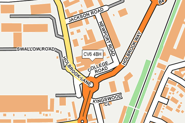
CV6 4BH is located in the Holbrook electoral ward, within the metropolitan district of Coventry and the English Parliamentary constituency of Coventry North West. The Sub Integrated Care Board (ICB) Location is NHS Coventry and Warwickshire ICB - B2M3M and the police force is West Midlands. This postcode has been in use since January 1980.


GetTheData
Source: OS OpenMap – Local (Ordnance Survey)
Source: OS VectorMap District (Ordnance Survey)
Licence: Open Government Licence (requires attribution)
| Easting | 433703 |
| Northing | 282178 |
| Latitude | 52.436559 |
| Longitude | -1.505659 |
GetTheData
Source: Open Postcode Geo
Licence: Open Government Licence
| Country | England |
| Postcode District | CV6 |
| ➜ CV6 open data dashboard ➜ See where CV6 is on a map ➜ Where is Coventry? | |
GetTheData
Source: Land Registry Price Paid Data
Licence: Open Government Licence
Elevation or altitude of CV6 4BH as distance above sea level:
| Metres | Feet | |
|---|---|---|
| Elevation | 100m | 328ft |
Elevation is measured from the approximate centre of the postcode, to the nearest point on an OS contour line from OS Terrain 50, which has contour spacing of ten vertical metres.
➜ How high above sea level am I? Find the elevation of your current position using your device's GPS.
GetTheData
Source: Open Postcode Elevation
Licence: Open Government Licence
| Ward | Holbrook |
| Constituency | Coventry North West |
GetTheData
Source: ONS Postcode Database
Licence: Open Government Licence
| June 2022 | Vehicle crime | On or near Holbrook Lane | 157m |
| June 2022 | Anti-social behaviour | On or near Jackson Road | 157m |
| June 2022 | Public order | On or near Delhi Avenue | 268m |
| ➜ Get more crime data in our Crime section | |||
GetTheData
Source: data.police.uk
Licence: Open Government Licence
| Burnaby Rd (Holbrook Lane) | Whitmore Park | 113m |
| Jackson Rd (Holbrook Lane) | Whitmore Park | 143m |
| Jackson Rd (Holbrook Lane) | Whitmore Park | 172m |
| Burnaby Rd (Holbrook Lane) | Whitmore Park | 237m |
| Holbrook Lane (Burnaby Rd) | Whitmore Park | 237m |
| Coventry Arena Station | 1.5km |
| Coventry Station | 4km |
| Canley Station | 5km |
GetTheData
Source: NaPTAN
Licence: Open Government Licence
GetTheData
Source: ONS Postcode Database
Licence: Open Government Licence


➜ Get more ratings from the Food Standards Agency
GetTheData
Source: Food Standards Agency
Licence: FSA terms & conditions
| Last Collection | |||
|---|---|---|---|
| Location | Mon-Fri | Sat | Distance |
| Durbar Avenue | 17:30 | 10:00 | 450m |
| Churchill Avenue | 17:15 | 10:15 | 477m |
| Burnaby Road | 19:00 | 11:15 | 713m |
GetTheData
Source: Dracos
Licence: Creative Commons Attribution-ShareAlike
| Facility | Distance |
|---|---|
| Holbrook Primary School Gateside Road, Coventry Grass Pitches | 586m |
| Holbrooks Park Holbrook Lane, Coventry Grass Pitches | 668m |
| Coventrians Rugby Club Black Pad, Off Yelverton Road, Coventry Grass Pitches | 676m |
GetTheData
Source: Active Places
Licence: Open Government Licence
| School | Phase of Education | Distance |
|---|---|---|
| Holbrook Primary School Gateside Road, Coventry, CV6 6FR | Primary | 586m |
| Lote Tree Primary School 643 Foleshill Road, Coventry, CV6 5JQ | Not applicable | 775m |
| Edgewick Community Primary School Cross Road, Off Foleshill Road, Coventry, CV6 5GP | Primary | 859m |
GetTheData
Source: Edubase
Licence: Open Government Licence
The below table lists the International Territorial Level (ITL) codes (formerly Nomenclature of Territorial Units for Statistics (NUTS) codes) and Local Administrative Units (LAU) codes for CV6 4BH:
| ITL 1 Code | Name |
|---|---|
| TLG | West Midlands (England) |
| ITL 2 Code | Name |
| TLG3 | West Midlands |
| ITL 3 Code | Name |
| TLG33 | Coventry |
| LAU 1 Code | Name |
| E08000026 | Coventry |
GetTheData
Source: ONS Postcode Directory
Licence: Open Government Licence
The below table lists the Census Output Area (OA), Lower Layer Super Output Area (LSOA), and Middle Layer Super Output Area (MSOA) for CV6 4BH:
| Code | Name | |
|---|---|---|
| OA | E00048568 | |
| LSOA | E01009587 | Coventry 011A |
| MSOA | E02001968 | Coventry 011 |
GetTheData
Source: ONS Postcode Directory
Licence: Open Government Licence
| CV6 4BN | Holbrook Lane | 80m |
| CV6 4BT | Jackson Road | 187m |
| CV6 5LZ | Durbar Avenue | 219m |
| CV6 4AB | Holbrook Lane | 245m |
| CV6 5LY | Durbar Avenue | 255m |
| CV6 4AD | Holbrook Lane | 257m |
| CV6 4BB | Burnaby Road | 287m |
| CV6 4BE | Burnaby Road | 290m |
| CV6 5LX | Delhi Avenue | 297m |
| CV6 4BY | Holbrook Lane | 303m |
GetTheData
Source: Open Postcode Geo; Land Registry Price Paid Data
Licence: Open Government Licence