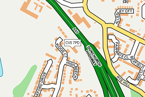
CV5 7PD is located in the Woodlands electoral ward, within the metropolitan district of Coventry and the English Parliamentary constituency of Coventry North West. The Sub Integrated Care Board (ICB) Location is NHS Coventry and Warwickshire ICB - B2M3M and the police force is West Midlands. This postcode has been in use since April 2003.


GetTheData
Source: OS OpenMap – Local (Ordnance Survey)
Source: OS VectorMap District (Ordnance Survey)
Licence: Open Government Licence (requires attribution)
| Easting | 429110 |
| Northing | 280860 |
| Latitude | 52.424957 |
| Longitude | -1.573341 |
GetTheData
Source: Open Postcode Geo
Licence: Open Government Licence
| Country | England |
| Postcode District | CV5 |
| ➜ CV5 open data dashboard ➜ See where CV5 is on a map ➜ Where is Coventry? | |
GetTheData
Source: Land Registry Price Paid Data
Licence: Open Government Licence
Elevation or altitude of CV5 7PD as distance above sea level:
| Metres | Feet | |
|---|---|---|
| Elevation | 120m | 394ft |
Elevation is measured from the approximate centre of the postcode, to the nearest point on an OS contour line from OS Terrain 50, which has contour spacing of ten vertical metres.
➜ How high above sea level am I? Find the elevation of your current position using your device's GPS.
GetTheData
Source: Open Postcode Elevation
Licence: Open Government Licence
| Ward | Woodlands |
| Constituency | Coventry North West |
GetTheData
Source: ONS Postcode Database
Licence: Open Government Licence
| September 2022 | Vehicle crime | On or near Larkfield Way | 223m |
| June 2022 | Criminal damage and arson | On or near Mackenzie Close | 331m |
| June 2022 | Anti-social behaviour | On or near Neale Avenue | 370m |
| ➜ Get more crime data in our Crime section | |||
GetTheData
Source: data.police.uk
Licence: Open Government Licence
| Neale Avenue (Birmingham Rd) | Allesley | 305m |
| Cameron Close (The Windmill Hill) | Allesley | 306m |
| Cameron Close (The Windmill Hill) | Allesley | 327m |
| Neale Avenue (Birmingham Rd) | Allesley | 405m |
| Parkhill Estate Terminus (Parkhill Dr) | Allesley Green | 436m |
| Canley Station | 3.4km |
| Tile Hill Station | 3.7km |
| Coventry Station | 4.9km |
GetTheData
Source: NaPTAN
Licence: Open Government Licence
GetTheData
Source: ONS Postcode Database
Licence: Open Government Licence


➜ Get more ratings from the Food Standards Agency
GetTheData
Source: Food Standards Agency
Licence: FSA terms & conditions
| Last Collection | |||
|---|---|---|---|
| Location | Mon-Fri | Sat | Distance |
| Birmingham Road | 16:45 | 10:45 | 249m |
| Parkhill Drive | 17:00 | 09:45 | 444m |
| Allesley Post Office | 18:30 | 10:45 | 606m |
GetTheData
Source: Dracos
Licence: Creative Commons Attribution-ShareAlike
| Facility | Distance |
|---|---|
| Windmill Village Hotel And Golf Club Birmingham Road, Allesley, Coventry Health and Fitness Gym, Swimming Pool, Golf | 286m |
| Allesley Primary School Antrim Close, Allesley, Coventry Grass Pitches | 438m |
| Park Hill Primary School Lower Eastern Green Lane, Coventry Grass Pitches | 950m |
GetTheData
Source: Active Places
Licence: Open Government Licence
| School | Phase of Education | Distance |
|---|---|---|
| Allesley Primary School Antrim Close, Allesley, Coventry, CV5 9FY | Primary | 445m |
| Park Hill Primary School Lower Eastern Green Lane, Eastern Green, Coventry, CV5 7LR | Primary | 950m |
| Allesley Hall Primary School Winsford Avenue, Coventry, CV5 9NG | Primary | 1.2km |
GetTheData
Source: Edubase
Licence: Open Government Licence
The below table lists the International Territorial Level (ITL) codes (formerly Nomenclature of Territorial Units for Statistics (NUTS) codes) and Local Administrative Units (LAU) codes for CV5 7PD:
| ITL 1 Code | Name |
|---|---|
| TLG | West Midlands (England) |
| ITL 2 Code | Name |
| TLG3 | West Midlands |
| ITL 3 Code | Name |
| TLG33 | Coventry |
| LAU 1 Code | Name |
| E08000026 | Coventry |
GetTheData
Source: ONS Postcode Directory
Licence: Open Government Licence
The below table lists the Census Output Area (OA), Lower Layer Super Output Area (LSOA), and Middle Layer Super Output Area (MSOA) for CV5 7PD:
| Code | Name | |
|---|---|---|
| OA | E00049088 | |
| LSOA | E01009704 | Coventry 023C |
| MSOA | E02001980 | Coventry 023 |
GetTheData
Source: ONS Postcode Directory
Licence: Open Government Licence
| CV5 7PZ | Ridge Court | 48m |
| CV5 7QD | High Beech | 99m |
| CV5 7PY | Woodridge Avenue | 122m |
| CV5 9BH | Fairways Close | 168m |
| CV5 7PP | Oakford Drive | 179m |
| CV5 9BJ | Niven Close | 201m |
| CV5 7QB | Larkfield Way | 235m |
| CV5 9PE | Allesley Croft | 253m |
| CV5 9HD | Birmingham Road | 259m |
| CV5 7PN | Woodridge Avenue | 262m |
GetTheData
Source: Open Postcode Geo; Land Registry Price Paid Data
Licence: Open Government Licence