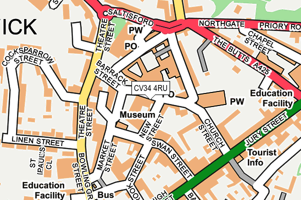
CV34 4RU is located in the Warwick Saltisford electoral ward, within the local authority district of Warwick and the English Parliamentary constituency of Warwick and Leamington. The Sub Integrated Care Board (ICB) Location is NHS Coventry and Warwickshire ICB - B2M3M and the police force is Warwickshire. This postcode has been in use since January 1980.


GetTheData
Source: OS OpenMap – Local (Ordnance Survey)
Source: OS VectorMap District (Ordnance Survey)
Licence: Open Government Licence (requires attribution)
| Easting | 428082 |
| Northing | 264978 |
| Latitude | 52.282232 |
| Longitude | -1.589781 |
GetTheData
Source: Open Postcode Geo
Licence: Open Government Licence
| Country | England |
| Postcode District | CV34 |
| ➜ CV34 open data dashboard ➜ See where CV34 is on a map ➜ Where is Warwick? | |
GetTheData
Source: Land Registry Price Paid Data
Licence: Open Government Licence
Elevation or altitude of CV34 4RU as distance above sea level:
| Metres | Feet | |
|---|---|---|
| Elevation | 70m | 230ft |
Elevation is measured from the approximate centre of the postcode, to the nearest point on an OS contour line from OS Terrain 50, which has contour spacing of ten vertical metres.
➜ How high above sea level am I? Find the elevation of your current position using your device's GPS.
GetTheData
Source: Open Postcode Elevation
Licence: Open Government Licence
| Ward | Warwick Saltisford |
| Constituency | Warwick And Leamington |
GetTheData
Source: ONS Postcode Database
Licence: Open Government Licence
| January 2024 | Criminal damage and arson | On or near Parking Area | 222m |
| December 2023 | Vehicle crime | On or near Parking Area | 317m |
| December 2023 | Vehicle crime | On or near Parking Area | 317m |
| ➜ Get more crime data in our Crime section | |||
GetTheData
Source: data.police.uk
Licence: Open Government Licence
| Northgate Methodist Church (North Rock) | Warwick | 157m |
| Warwick Arms (High Street) | Warwick | 195m |
| Kings Head (Saltisford) | Warwick | 209m |
| Bus Station (Private Road) | Warwick | 213m |
| Kings High School (The Butts) | Warwick | 272m |
| Warwick Station | 0.7km |
| Warwick Parkway Station | 1.6km |
| Leamington Spa Station | 3.7km |
GetTheData
Source: NaPTAN
Licence: Open Government Licence
GetTheData
Source: ONS Postcode Database
Licence: Open Government Licence


➜ Get more ratings from the Food Standards Agency
GetTheData
Source: Food Standards Agency
Licence: FSA terms & conditions
| Last Collection | |||
|---|---|---|---|
| Location | Mon-Fri | Sat | Distance |
| Shire Hall | 19:00 | 12:30 | 16m |
| Shire Hall | 19:00 | 12:30 | 17m |
| Brook Street Post Office | 19:00 | 12:15 | 146m |
GetTheData
Source: Dracos
Licence: Creative Commons Attribution-ShareAlike
| Facility | Distance |
|---|---|
| The Kings High School For Girls (Closed) Chapel Street, Warwick Sports Hall, Health and Fitness Gym | 354m |
| Fitness Worx (Warwick) Cattell Road, Cape Industrial Estate, Warwick Health and Fitness Gym | 472m |
| The Warwick Boat Club Ltd Mill Street, Warwick Squash Courts, Outdoor Tennis Courts | 581m |
GetTheData
Source: Active Places
Licence: Open Government Licence
| School | Phase of Education | Distance |
|---|---|---|
| Westgate Primary School Bowling Green Street, Warwick, CV34 4DD | Primary | 257m |
| Warwick Nursery School Coventry Road, Warwick, CV34 4LJ | Nursery | 615m |
| St Mary Immaculate Catholic Primary School Wathen Road, Warwick, CV34 5BG | Primary | 648m |
GetTheData
Source: Edubase
Licence: Open Government Licence
The below table lists the International Territorial Level (ITL) codes (formerly Nomenclature of Territorial Units for Statistics (NUTS) codes) and Local Administrative Units (LAU) codes for CV34 4RU:
| ITL 1 Code | Name |
|---|---|
| TLG | West Midlands (England) |
| ITL 2 Code | Name |
| TLG1 | Herefordshire, Worcestershire and Warwickshire |
| ITL 3 Code | Name |
| TLG13 | Warwickshire CC |
| LAU 1 Code | Name |
| E07000222 | Warwick |
GetTheData
Source: ONS Postcode Directory
Licence: Open Government Licence
The below table lists the Census Output Area (OA), Lower Layer Super Output Area (LSOA), and Middle Layer Super Output Area (MSOA) for CV34 4RU:
| Code | Name | |
|---|---|---|
| OA | E00159715 | |
| LSOA | E01031324 | Warwick 011D |
| MSOA | E02006529 | Warwick 011 |
GetTheData
Source: ONS Postcode Directory
Licence: Open Government Licence
| CV34 4RX | New Street | 36m |
| CV34 4SA | Market Place | 47m |
| CV34 4RA | Old Square | 53m |
| CV34 4TH | Barrack Street | 71m |
| CV34 4SL | Market Place | 81m |
| CV34 4SJ | The Holloway | 86m |
| CV34 4SD | Market Place | 98m |
| CV34 4BJ | Swan Street | 109m |
| CV34 4WP | The Woolpack | 115m |
| CV34 4DY | Theatre Court | 128m |
GetTheData
Source: Open Postcode Geo; Land Registry Price Paid Data
Licence: Open Government Licence