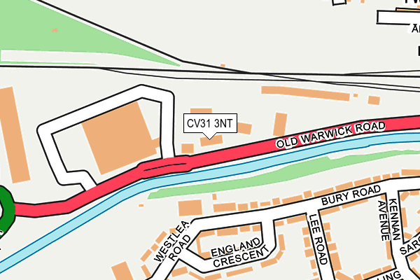
CV31 3NT is located in the Leamington Brunswick electoral ward, within the local authority district of Warwick and the English Parliamentary constituency of Warwick and Leamington. The Sub Integrated Care Board (ICB) Location is NHS Coventry and Warwickshire ICB - B2M3M and the police force is Warwickshire. This postcode has been in use since January 1980.


GetTheData
Source: OS OpenMap – Local (Ordnance Survey)
Source: OS VectorMap District (Ordnance Survey)
Licence: Open Government Licence (requires attribution)
| Easting | 431284 |
| Northing | 265171 |
| Latitude | 52.283810 |
| Longitude | -1.542817 |
GetTheData
Source: Open Postcode Geo
Licence: Open Government Licence
| Country | England |
| Postcode District | CV31 |
| ➜ CV31 open data dashboard ➜ See where CV31 is on a map ➜ Where is Royal Leamington Spa? | |
GetTheData
Source: Land Registry Price Paid Data
Licence: Open Government Licence
Elevation or altitude of CV31 3NT as distance above sea level:
| Metres | Feet | |
|---|---|---|
| Elevation | 60m | 197ft |
Elevation is measured from the approximate centre of the postcode, to the nearest point on an OS contour line from OS Terrain 50, which has contour spacing of ten vertical metres.
➜ How high above sea level am I? Find the elevation of your current position using your device's GPS.
GetTheData
Source: Open Postcode Elevation
Licence: Open Government Licence
| Ward | Leamington Brunswick |
| Constituency | Warwick And Leamington |
GetTheData
Source: ONS Postcode Database
Licence: Open Government Licence
| January 2024 | Anti-social behaviour | On or near Parking Area | 329m |
| November 2023 | Other theft | On or near Parking Area | 323m |
| November 2023 | Other theft | On or near Parking Area | 323m |
| ➜ Get more crime data in our Crime section | |||
GetTheData
Source: data.police.uk
Licence: Open Government Licence
| Westbury Centre (Bury Road) | Leamington Spa | 119m |
| Morrisons (Old Warwick Road) | Leamington Spa | 159m |
| Morrisons (Old Warwick Road) | Leamington Spa | 178m |
| Kennan Avenue (Bury Road) | Leamington Spa | 267m |
| Victoria Street (Avenue Road) | Leamington Spa | 268m |
| Leamington Spa Station | 0.5km |
| Warwick Station | 2.7km |
| Warwick Parkway Station | 4.7km |
GetTheData
Source: NaPTAN
Licence: Open Government Licence
GetTheData
Source: ONS Postcode Database
Licence: Open Government Licence


➜ Get more ratings from the Food Standards Agency
GetTheData
Source: Food Standards Agency
Licence: FSA terms & conditions
| Last Collection | |||
|---|---|---|---|
| Location | Mon-Fri | Sat | Distance |
| Adelaide Road | 17:00 | 11:30 | 358m |
| Lee Road | 16:00 | 11:45 | 385m |
| Kingsway | 16:00 | 11:45 | 439m |
GetTheData
Source: Dracos
Licence: Creative Commons Attribution-ShareAlike
| Facility | Distance |
|---|---|
| Bury Road (Closed) Bury Road, Leamington Spa Grass Pitches | 285m |
| Victoria Park (Leamington Spa) Archery Road, Leamington Spa Grass Pitches, Outdoor Tennis Courts | 352m |
| Fwx Leamington Spencer Street, Leamington Spa Health and Fitness Gym, Studio | 610m |
GetTheData
Source: Active Places
Licence: Open Government Licence
| School | Phase of Education | Distance |
|---|---|---|
| St Peter's Catholic Primary School Augusta Place, Leamington Spa, CV32 5EL | Primary | 663m |
| Kingsway Community Primary School Baker Avenue, Leamington Spa, CV31 3HB | Primary | 673m |
| St Patrick's Catholic Primary School Cashmore Avenue, Leamington Spa, CV31 3EU | Primary | 786m |
GetTheData
Source: Edubase
Licence: Open Government Licence
The below table lists the International Territorial Level (ITL) codes (formerly Nomenclature of Territorial Units for Statistics (NUTS) codes) and Local Administrative Units (LAU) codes for CV31 3NT:
| ITL 1 Code | Name |
|---|---|
| TLG | West Midlands (England) |
| ITL 2 Code | Name |
| TLG1 | Herefordshire, Worcestershire and Warwickshire |
| ITL 3 Code | Name |
| TLG13 | Warwickshire CC |
| LAU 1 Code | Name |
| E07000222 | Warwick |
GetTheData
Source: ONS Postcode Directory
Licence: Open Government Licence
The below table lists the Census Output Area (OA), Lower Layer Super Output Area (LSOA), and Middle Layer Super Output Area (MSOA) for CV31 3NT:
| Code | Name | |
|---|---|---|
| OA | E00159412 | |
| LSOA | E01031265 | Warwick 013E |
| MSOA | E02006531 | Warwick 013 |
GetTheData
Source: ONS Postcode Directory
Licence: Open Government Licence
| CV31 3JD | Bury Road | 148m |
| CV31 3JH | England Crescent | 157m |
| CV31 3HW | Bury Road | 182m |
| CV31 3JE | Westlea Road | 187m |
| CV31 3JB | Bury Road | 244m |
| CV31 3JF | Westlea Road | 246m |
| CV31 3JG | Lee Road | 249m |
| CV31 3JJ | Westlea Road | 250m |
| CV31 3PF | Avenue Road | 271m |
| CV31 3PE | Avenue Road | 298m |
GetTheData
Source: Open Postcode Geo; Land Registry Price Paid Data
Licence: Open Government Licence