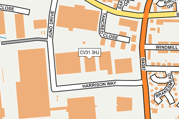
CV31 3HJ is located in the Leamington Brunswick electoral ward, within the local authority district of Warwick and the English Parliamentary constituency of Warwick and Leamington. The Sub Integrated Care Board (ICB) Location is NHS Coventry and Warwickshire ICB - B2M3M and the police force is Warwickshire. This postcode has been in use since November 2005.


GetTheData
Source: OS OpenMap – Local (Ordnance Survey)
Source: OS VectorMap District (Ordnance Survey)
Licence: Open Government Licence (requires attribution)
| Easting | 431762 |
| Northing | 264167 |
| Latitude | 52.274757 |
| Longitude | -1.535905 |
GetTheData
Source: Open Postcode Geo
Licence: Open Government Licence
| Country | England |
| Postcode District | CV31 |
| ➜ CV31 open data dashboard ➜ See where CV31 is on a map ➜ Where is Royal Leamington Spa? | |
GetTheData
Source: Land Registry Price Paid Data
Licence: Open Government Licence
Elevation or altitude of CV31 3HJ as distance above sea level:
| Metres | Feet | |
|---|---|---|
| Elevation | 60m | 197ft |
Elevation is measured from the approximate centre of the postcode, to the nearest point on an OS contour line from OS Terrain 50, which has contour spacing of ten vertical metres.
➜ How high above sea level am I? Find the elevation of your current position using your device's GPS.
GetTheData
Source: Open Postcode Elevation
Licence: Open Government Licence
| Ward | Leamington Brunswick |
| Constituency | Warwick And Leamington |
GetTheData
Source: ONS Postcode Database
Licence: Open Government Licence
| January 2024 | Anti-social behaviour | On or near Sapphire Drive | 219m |
| January 2024 | Public order | On or near Silver Birch Grove | 261m |
| December 2023 | Anti-social behaviour | On or near Sapphire Drive | 219m |
| ➜ Get more crime data in our Crime section | |||
GetTheData
Source: data.police.uk
Licence: Open Government Licence
| Windmill Inn (Tachbrook Road) | Leamington Spa | 69m |
| Windmill Inn (Tachbrook Road) | Leamington Spa | 115m |
| Cashmore Avenue (Tachbrook Road) | Leamington Spa | 245m |
| Wych Elm Drive (St Helens Road) | Leamington Spa | 315m |
| Heathcote Road (Tachbrook Road) | Leamington Spa | 317m |
| Leamington Spa Station | 1.1km |
| Warwick Station | 3.4km |
GetTheData
Source: NaPTAN
Licence: Open Government Licence
GetTheData
Source: ONS Postcode Database
Licence: Open Government Licence


➜ Get more ratings from the Food Standards Agency
GetTheData
Source: Food Standards Agency
Licence: FSA terms & conditions
| Last Collection | |||
|---|---|---|---|
| Location | Mon-Fri | Sat | Distance |
| Tachbrook Street | 16:30 | 12:00 | 377m |
| Kingsway | 16:00 | 11:45 | 701m |
| Charlotte Street | 16:45 | 12:15 | 724m |
GetTheData
Source: Dracos
Licence: Creative Commons Attribution-ShareAlike
| Facility | Distance |
|---|---|
| Puregym (Leamington Spa) Queensway Trading Estate, Leamington Spa Health and Fitness Gym | 145m |
| St Patrick's Catholic Primary School Cashmore Avenue, Leamington Spa Grass Pitches | 337m |
| Kingsway School Baker Avenue, Leamington Spa Grass Pitches | 449m |
GetTheData
Source: Active Places
Licence: Open Government Licence
| School | Phase of Education | Distance |
|---|---|---|
| St Patrick's Catholic Primary School Cashmore Avenue, Leamington Spa, CV31 3EU | Primary | 334m |
| Kingsway Community Primary School Baker Avenue, Leamington Spa, CV31 3HB | Primary | 440m |
| Whitnash Primary School Langley Road, Whitnash, Leamington Spa, CV31 2EX | Primary | 704m |
GetTheData
Source: Edubase
Licence: Open Government Licence
The below table lists the International Territorial Level (ITL) codes (formerly Nomenclature of Territorial Units for Statistics (NUTS) codes) and Local Administrative Units (LAU) codes for CV31 3HJ:
| ITL 1 Code | Name |
|---|---|
| TLG | West Midlands (England) |
| ITL 2 Code | Name |
| TLG1 | Herefordshire, Worcestershire and Warwickshire |
| ITL 3 Code | Name |
| TLG13 | Warwickshire CC |
| LAU 1 Code | Name |
| E07000222 | Warwick |
GetTheData
Source: ONS Postcode Directory
Licence: Open Government Licence
The below table lists the Census Output Area (OA), Lower Layer Super Output Area (LSOA), and Middle Layer Super Output Area (MSOA) for CV31 3HJ:
| Code | Name | |
|---|---|---|
| OA | E00159394 | |
| LSOA | E01031262 | Warwick 013B |
| MSOA | E02006531 | Warwick 013 |
GetTheData
Source: ONS Postcode Directory
Licence: Open Government Licence
| CV31 3RP | Bonniksen Close | 124m |
| CV31 3EN | Tachbrook Road | 139m |
| CV31 3RR | Brakesmead | 152m |
| CV31 3LB | Sapphire Drive | 195m |
| CV31 3DH | Culworth Close | 204m |
| CV31 3RS | Lockheed Close | 209m |
| CV31 3ES | Windmill Road | 220m |
| CV31 3DD | Tachbrook Road | 232m |
| CV31 3QY | Silver Birch Grove | 233m |
| CV31 3LD | Emerald Way | 252m |
GetTheData
Source: Open Postcode Geo; Land Registry Price Paid Data
Licence: Open Government Licence